Weather
Heavy Rain, Gusty Winds: Hour-By-Hour Hudson Valley Forecast
Here is when the rain is expected to start and how long it may last.

We hope you enjoyed Saturday's weather and hope you will enjoy most of Sunday's, because possibly heavy rain and the risk of severe thunderstorms in is the forecast. The National Weather Service issued a hazardous weather outlook for Orange and Rockland counties for Sunday night into early Monday morning.
The main threat will be from damaging wind gusts, and locally heavy rainfall could cause some flooding.
SEE ALSO: Hazardous Weather Outlook For Rockland, Orange Counties
Find out what's happening in Yorktown-Somersfor free with the latest updates from Patch.
There is also a hazardous weather outlook for Columbia, Dutchess and Ulster counties calling for locally heavy rain possible from Sunday afternoon into the night. Isolated thunderstorms are also possible Sunday night into Monday morning.
Then the mid-Hudson Valley can look forward to wind gusts over 40 mph Monday afternoon and night.
Find out what's happening in Yorktown-Somersfor free with the latest updates from Patch.
For Sunday around the Hudson Valley, there will be clouds and breaks of sunshine through the day.
"As the afternoon progresses, we'll see a few spotty rain showers and sprinkles around parts of the valley," Hudson Valley Weather said on Facebook. "These should be very few and far between until after 4 p.m. … but we can't rule out the chance for a spot shower or two."
HVW said the heavier rain and T-storms will likely arrive between 2 a.m. and 6 a.m.
Here is the forecast for northern Westchester from the NWS for the next couple of days:
- Sunday: A chance of drizzle or light rain after 2pm. Increasing clouds, with a high near 67. Southeast wind around 7 mph. Chance of precipitation is 40%.
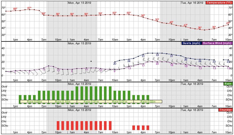
- Sunday Night: Showers likely, then showers and possibly a thunderstorm after 10pm. Some of the storms could produce heavy rainfall. Areas of fog. Low around 57. South wind 9 to 14 mph. Chance of precipitation is 90%. New rainfall amounts between a quarter and half of an inch possible.
- Monday: Showers and possibly a thunderstorm before 10am, then showers likely between 10am and 2pm, then a chance of showers and thunderstorms after 2pm. Some of the storms could produce heavy rainfall. Areas of fog before 10am. Temperature rising to near 60 by 8am, then falling to around 54 during the remainder of the day. West wind 9 to 16 mph, with gusts as high as 28 mph. Chance of precipitation is 80%. New rainfall amounts between a quarter and half of an inch possible.
- Monday Night: Partly cloudy, with a low around 36. Wind chill values between 30 and 35. Breezy, with a northwest wind 14 to 20 mph, with gusts as high as 33 mph.
- Tuesday: Sunny, with a high near 59. West wind around 14 mph, with gusts as high as 24 mph.
Get more local news delivered straight to your inbox. Sign up for free Patch newsletters and alerts.


