Community Corner
National Weather Service Issues Blizzard Warning for Somers, Yorktown
30 inches possible, wind gusts up to 45 miles an hour

The National Weather Service has upgraded its bulletin to a Blizzard Warning. The exact track of Storm Juno could mean the difference between two and three feet of snow locally between tomorrow morning and the end of Jan. 27.
Here’s the day-by-day for Yorktown from the National Weather Service.
- Monday-A chance of snow before noon, then snow likely with widespread blowing snow between noon and 3pm, then snow with widespread blowing snow after 3pm. High near 23. Wind chill values between zero and 10. Northeast wind 7 to 13 mph, with gusts as high as 23 mph. Chance of precipitation is 80%. New snow accumulation of 1 to 3 inches possible.
- Monday Night-Snow with widespread blowing snow. The snow could be heavy at times. Some thunder is also possible. Low around 17. Wind chill values between zero and 10. Windy, with a north wind 16 to 21 mph increasing to 23 to 28 mph after midnight. Winds could gust as high as 40 mph. Chance of precipitation is 100%. New snow accumulation of 10 to 16 inches possible.
- Tuesday-Snow with widespread blowing snow. The snow could be heavy at times. Some thunder is also possible. High near 21. Wind chill values between zero and 5. Windy, with a north wind around 30 mph, with gusts as high as 45 mph. Chance of precipitation is 100%. New snow accumulation of 11 to 17 inches possible.
- Tuesday Night-Snow with widespread blowing snow before midnight, then widespread blowing snow and a chance of snow between midnight and 3am, then widespread blowing snow and a slight chance of snow after 3am. Low around 11. Windy, with a northwest wind 25 to 30 mph decreasing to 17 to 22 mph after midnight. Winds could gust as high as 43 mph. Chance of precipitation is 80%. New snow accumulation of 1 to 2 inches possible.
“This could turn out to be the biggest storm of the winter for many areas in the Northeast and could rank among the greatest snowstorms in some communities,” accuweather.com meteorologists said.
Find out what's happening in Yorktown-Somersfor free with the latest updates from Patch.
Hudson Valley Weather says there are four things that could push snowfall totals up or bring them down:
Storm Track – 50 miles can make a world of difference in the weather world, especially when pertaining to nor’easters.
Find out what's happening in Yorktown-Somersfor free with the latest updates from Patch.
Snow Ratio – normally, for every 1″ of liquid that falls from the sky, you get 10″ of snow. However, when the air temperatures are colder, that ratio changes.
Snow Banding – In every snowstorm, snow bands set up... and can lead to surprise snow totals.
Storm Stalling – This is easily the biggest wildcard as far as we are concerned. The European model stalls the storm out just east of Long Island, and actually backs it in toward the coast for about 12 hours.… we’ll have to wait and see.
Please make sure you have the supplies and medications you will need over next few days. Check on your neighbors, including the elderly. If you have to venture out during the snow, remove all snow from your car before driving.
The snow won’t be going anywhere when the storm ends. Temperatures are expected to dip, and more snow is expected toward the end of the week.
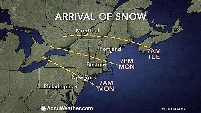
MAP: accuweather.com
Get more local news delivered straight to your inbox. Sign up for free Patch newsletters and alerts.