Weather
Showers, Thunderstorms To Start Work Week: Hudson Valley Weather
Hazardous weather is forecast for parts of the Hudson Valley. See what you can expect.

HUDSON VALLEY, NY — We hope you enjoyed the weekend weather, with the blue skies, warm temperatures and low humidity. All that is over now that the work week has begun.
Rain and the threat of thunderstorms are headed to the Hudson Valley, along with cooler temperatures.
"Clouds will increase through the region early on Monday," said Alex Marra and Bill Potter of Hudson Valley Weather, "and that will help keep temperatures near or below 70 degrees for the majority of the region. Rain showers will begin to develop around the HV as we near midday."
Find out what's happening in Yorktown-Somersfor free with the latest updates from Patch.
The likelihood of rain showers is forecast to increase through the afternoon and will bring along more showers and some thunder into Monday night.
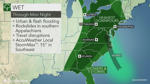
There is even a hazardous weather outlook for parts of the mid-Hudson Valley — specifically Columbia, Dutchess and Ulster counties — for Monday and Monday night.
Find out what's happening in Yorktown-Somersfor free with the latest updates from Patch.
The National Weather Service said that locally heavy rainfall is expected Monday into early Tuesday morning. Some ponding of water on roadways and poor drainage flooding of urban and low-lying areas may occur within areas of heavier rainfall and isolated thunderstorms.
The NWS said an isolated flash flood is possible, especially if heavy downpours and thunderstorms repeatedly move across the same area.
For the rest of the week, we can expected the chance of showers and thunderstorms every day except for Friday.
Here is the forecast for northern Westchester from the NWS for the work week:
- Monday: A chance of showers, then showers and possibly a thunderstorm after 1pm. High near 67. East wind 5 to 8 mph. Chance of precipitation is 100%. New rainfall amounts between a quarter and half of an inch possible.
- Monday Night: Showers and possibly a thunderstorm. Steady temperature around 66. Southeast wind 3 to 7 mph. Chance of precipitation is 100%. New rainfall amounts between a half and three quarters of an inch possible.
- Tuesday: Showers likely and possibly a thunderstorm before 9am, then a chance of showers and thunderstorms between 9am and 1pm. Cloudy through mid morning, then gradual clearing, with a high near 75. Northwest wind 5 to 10 mph increasing to 13 to 18 mph in the afternoon. Winds could gust as high as 28 mph. Chance of precipitation is 70%. New rainfall amounts between a quarter and half of an inch possible.
- Tuesday Night: Mostly clear, with a low around 53. Northwest wind 8 to 13 mph becoming light after midnight.
- Wednesday: Mostly sunny, with a high near 73. Light and variable wind.
- Wednesday Night: A 50 percent chance of showers after 3am. Mostly cloudy, with a low around 56.
- Thursday: Showers likely, with thunderstorms also possible after 1pm. Mostly cloudy, with a high near 68. Chance of precipitation is 70%.
- Thursday Night: A chance of showers and thunderstorms before 7pm, then a chance of showers between 7pm and 1am. Mostly cloudy, with a low around 57. Chance of precipitation is 50%.
- Friday: Mostly sunny, with a high near 74.
- Friday Night: Mostly clear, with a low around 57.
Get more local news delivered straight to your inbox. Sign up for free Patch newsletters and alerts.


