Weather
Trick or Treat? Halloween Weekend Forecast for Yorktown, Somers
We've a fun-packed weekend ahead. Will there be a washout? Get details including an early prediction about Tuesday evening.

SOMERS, NY — Halloween festivities kick into high gear as folks head to the many, many activities offered across the Hudson Valley for the weekend leading up to All Hallows Eve on Tuesday. Right now, it looks as if only Sunday will be a washout for outdoor events. Nor'easter conditions are expected in the region.
The meteorologists at Hudson Valley Weather are watching the coming storm very closely. "It’s a VERY complicated forecast that involves a strong trough of low pressure, interacting with some tropical energy from the Caribbean," said Bill Potter from HVW. "The result should be some heavy rain and high winds across the region."
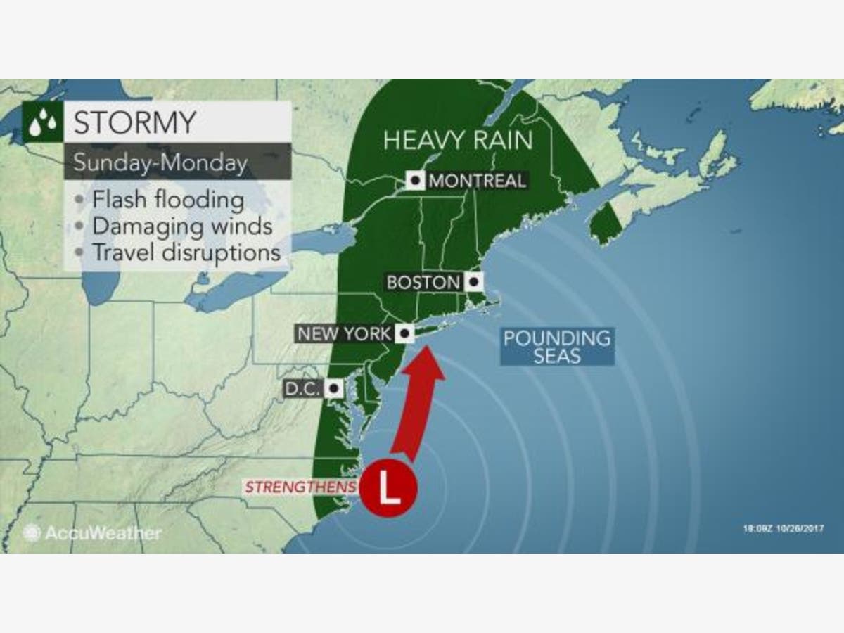
The National Weather Service updated its Hazardous Outlook Friday morning, but the details were unchanged from Thursday:
Find out what's happening in Yorktown-Somersfor free with the latest updates from Patch.
The potential exists for a strong cold front to approach from the west, while an intensifying storm moves up the coast, Sunday into Sunday night. This storm could produce heavy rain capable of causing areal and small stream flooding during this time frame. Strong winds will also be possible across the area.
Conditions may never coalesce into an actual tropical storm. But it's the experience that counts.
"Regardless of official tropical storm designation or not, this storm will pack a punch in terms of the consequences of heavy rainfall and gusty winds in a large part of the Northeast later this weekend into the start of the new week," said Alex Sosnowski, AccuWeather senior meteorologist.
Find out what's happening in Yorktown-Somersfor free with the latest updates from Patch.
Here's the NWS's current forecast for the weekend in northern Westchester, plus an early peek at Halloween night:
- Today-Sunny. Highs in the lower 60s. Southwest winds around 5 mph.
- Tonight-Clear. Lows in the mid 40s. South winds around 5 mph in the evening, becoming light and variable.
- Saturday-Mostly sunny. Highs in the mid 60s. Southeast winds 5 to 10 mph. Gusts up to 20 mph in the afternoon.
- Saturday Night-Mostly cloudy. A chance of showers in the evening, then showers likely after midnight. Lows in the mid 50s. South winds 10 to 15 mph. Chance of rain 70 percent.
- Sunday-Showers with a slight chance of thunderstorms. Locally heavy rainfall possible in the afternoon. Highs in the mid 60s. Southeast winds 15 to 20 mph with gusts up to 30 mph. Chance of rain 90 percent.
- Sunday Night-Showers. Locally heavy rainfall possible in the evening. Lows in the mid 40s. Chance of rain 90 percent.
- Monday-Mostly cloudy with a chance of showers in the morning, then mostly sunny in the afternoon. Highs in the mid 50s. Chance of rain 40 percent.
- Monday Night-Partly cloudy in the evening, then becoming mostly clear. Lows around 40.
- Tuesday-Mostly sunny. Highs in the upper 50s.
- Tuesday Night-Mostly clear in the evening, then becoming partly cloudy. Lows in the upper 30s.
Image via AccuWeather.com
Get more local news delivered straight to your inbox. Sign up for free Patch newsletters and alerts.


