Weather
Timeline For Nasty Halloween Storm In North Carolina
A line of thunderstorms moving into the piedmont this afternoon could become severe and pack gusty winds and torrential downpours.

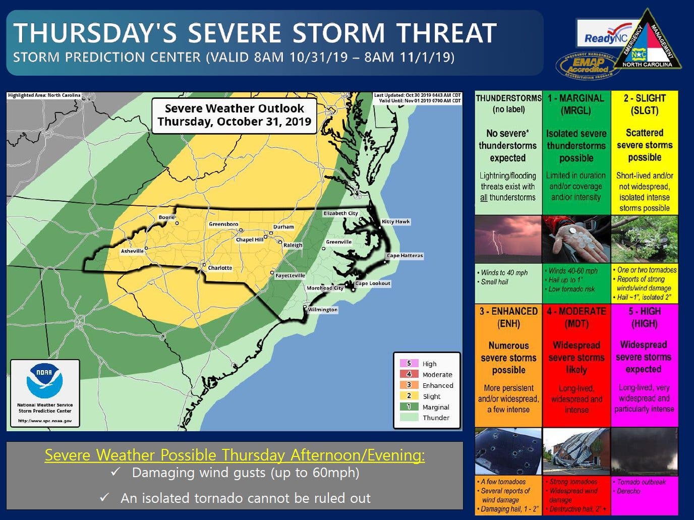
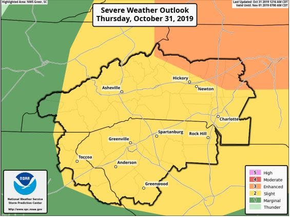
NORTH CAROLINA — A nasty Halloween storm that could bring severe weather, thunder and lightning and the possibility of gusty winds to much of western and central North Carolina is expected to arrive by this afternoon, according to the National Weather Service.
Heavy rain isn’t the only weather concern for the days ahead, according to forecasters, who say frost may develop around the piedmont of the Tar Heel State every morning from Saturday through Monday, Nov. 4. (See the hour-by-hour forecast for the Charlotte metro region below).
Thursday morning, the National Weather Service issued a hazardous weather outlook for the greater Charlotte metro region, saying a line of showers moving into the area this afternoon will strengthen, with some thunderstorms becoming severe over the Interstate 77 corridor.
Find out what's happening in Charlottefor free with the latest updates from Patch.
RELATED: NC Ghosts: Here's A List Of State's Most Haunted Places
“Any of these storms will produce cloud-to-ground lightning, gusty winds, and torrential downpours,” NWS said. “Some thunderstorms may also produce damaging wind gusts or an isolated tornado.”
Find out what's happening in Charlottefor free with the latest updates from Patch.
Here is the National Weather Service’s summary forecast through Nov. 6:
Oct. 31 (Halloween)
Showers likely and possibly a thunderstorm before 1pm, then showers and thunderstorms likely between 1pm and 5pm, then occasional showers and possibly a thunderstorm after 5pm. High near 78. South southwest wind 13 to 16 mph, with gusts as high as 26 mph. Chance of precipitation is 80%. New rainfall amounts between a tenth and quarter of an inch, except higher amounts possible in thunderstorms.
Tonight
Occasional showers and possibly a thunderstorm before 1am, then a slight chance of showers between 1am and 2am. Low around 41. Southwest wind 9 to 16 mph becoming northwest after midnight. Winds could gust as high as 26 mph. Chance of precipitation is 80%. New precipitation amounts between a quarter and half of an inch possible.
Friday (Nov. 1)
Sunny, with a high near 60. North northwest wind around 6 mph becoming calm in the afternoon.
Friday Night
Mostly clear, with a low around 38. Calm wind.
Saturday (Nov. 2)
Patchy frost before 10am. Otherwise, sunny, with a high near 62. Calm wind.
Saturday Night
Mostly clear, with a low around 38.
Sunday (Nov. 3)
Patchy frost before 10am. Otherwise, sunny, with a high near 58.
Sunday Night
Areas of frost after 4am. Otherwise, mostly clear, with a low around 37.
Monday (Nov. 4)
Areas of frost before 10am. Otherwise, sunny, with a high near 62.
Monday Night
Mostly cloudy, with a low around 46.
Tuesday (Nov. 5)
A 30 percent chance of showers. Mostly cloudy, with a high near 67.
Tuesday Night
A 30 percent chance of showers. Partly cloudy, with a low around 50.
Wednesday (Nov. 6)
Mostly sunny, with a high near 70.
Here is the forecast timeline for the Charlotte metro and Lake Norman region going into Thursday evening:
11 a.m.
- Temperature: 73 degrees
- Wind: 14 mph, gusts up to 22 mph
- Rain:
Noon
- Temperature: 74 degrees
- Wind: 14 mph, gusts up to 23 mph
- Rain — 62 percent chance
3 p.m.
- Temperature: 76 degrees
- Wind: 16 mph, gusts up to 26 mph
- Rain — 71 percent chance
6 p.m.
- Temperature: 73 degrees
- Wind: 16 mph, gusts up to 28 mph
- Rain — 81percent chance
9 p.m.
- Temperature: 63 degrees
- Wind: 15 mph, gusts up to 24 mph
- Rain — 48 percent chance
RELATED:
- Here's North Carolina's Most Popular Halloween Costume: Google
- Halloween Candy: Here's The Most Popular Sweet Treat In NC
- North Carolina Haunted House Guide 2019
- Best Places For Halloween 2019: How Charlotte Metro Compares
Get more local news delivered straight to your inbox. Sign up for free Patch newsletters and alerts.