Schools
Hurricane Irma: Mooresville Schools Monitoring Weather
Hurricane Irma's shift west takes N.C. out of its direct path, and means Mooresville Schools will be open.

MOORESVILLE, NC -- Hurricane Irma’s westward shift in Friday forecasts is good news for North Carolina, but likely will be disappointing news for kids hoping for a day out of school in Mooresville early next week.
Mooresville Graded School District is monitoring the forecasts for Irma’s path, it said Friday.
“Mooresville Graded School District recognizes the potential threat posed by Hurricane Irma, and is closely monitoring the track of this storm,” the school district said in a statement Friday. “The latest storm models show the Mooresville area will likely only see wind and rain, but should this change in a way that affects the ability to have school, we will let parents know as soon as possible via CONNECT5, social media, the MGSD website, and local news stations.
Find out what's happening in Mooresvillefor free with the latest updates from Patch.
MGSD school officials are asking all students and parents to cooperate by following these suggestions:
- Make sure your phone number(s) and contact information are updated in the CONNECT5 automated call system, as we will send a message via CONNECT5 soon after the decision has been made.
- Listen to one of the television or radio stations listed, or check listed web sites. Media outlets will post announcements at their earliest convenience.
- DO NOT call the weather bureau, television or radio stations, newspaper offices, school officials or cablevision.
In the case of severe weather, the following radio and TV stations are notified:
Television
Find out what's happening in Mooresvillefor free with the latest updates from Patch.
- WBTV, Channel 3 (CBS)
- WCNC, Channel 36/6 (NBC) WSOC, Channel 9 (ABC)
- MNN Channel 21 (Mi-Connection)
Social Media Sites
- Facebook - @MooresvilleGradedSchoolDistrict
Radio
- WHIP 1350 AM

Even with the westward shift, North Carolina could still see flash flooding, tornadoes and even landslides in the mountain areas as a result of the mega storm.
“Things are looking better for North Carolina but we can’t let our guard down,” N.C. Gov. Roy Cooper said Friday afternoon at a press conference.
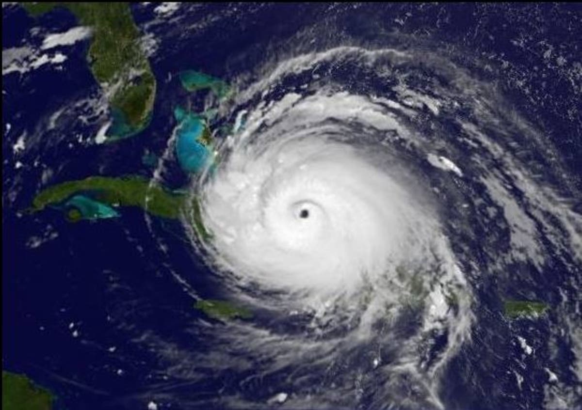
Irma is “roughly the size of the state of Texas,” Cooper said. “We know that even if North Carolina is spared a direct hit some parts of our state could still see serious impacts, particularly in the Western part of our state. (Get Patch real-time email alerts for the latest news in Mooresville — or other neighborhoods. And iPhone users: Check out Patch's new app.)
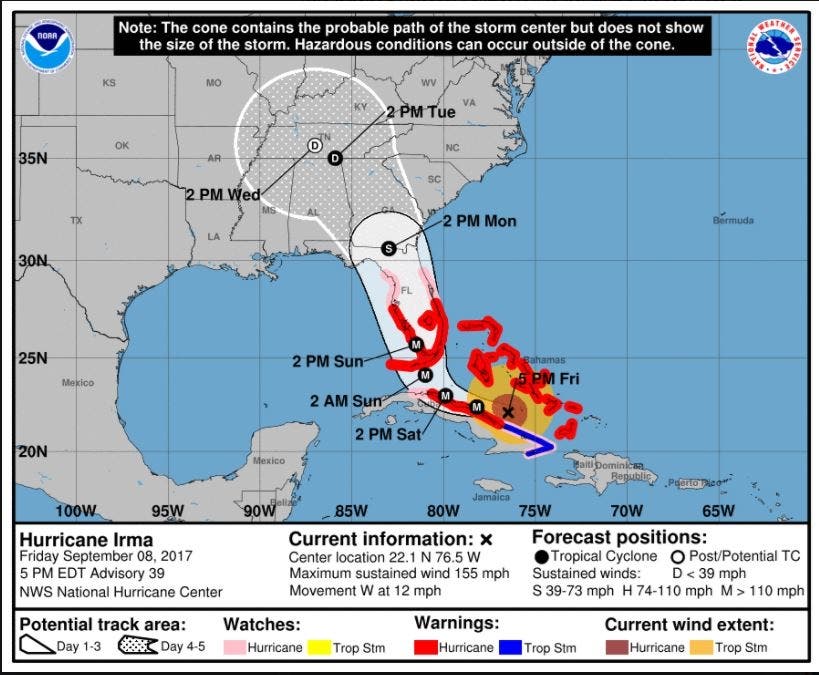
The NWS’ 11 a.m. forecast shows that by 8 a.m. Sept. 12, Irma’s cone will flank the western edge of North Carolina and South Carolina, bringing rain and sustained tropical winds up 39 mph to the region. The cone, however, will just skirting the Queen City metro area to the west. A day later, the storm will be centered over central Tennessee.
According to the National Hurricane Center, Western North Carolina, South Carolina and Georgia will experience periods of heavy rain, which will lead to a risk of flooding and flash flooding.
“There’s a chance of direct impacts in portions of Georgia, South Carolina and North Carolina, but it’s too early to specify the magnitude and location of these impacts,” the National Weather Service said Friday morning.
Cooper, who said Friday the state-wide emergency would stay in effect until the storm passed, has stressed that residents should prepare even as projections had a weakened Irma entering the state well inland early next week.
"This storm can impact any part of North Carolina — all over our state from the mountains to the coast," Cooper said. "Just because that it might be at tropical-storm strength doesn't mean this storm isn't going to be very dangerous."
On its current path, Irma is expected to clear the northern Cuban coastline by Saturday and make its way up the center of Florida in the early morning hours Monday. Forecasters say Irma’s hurricane-force winds extend out 70 miles from the center while tropical storm-force winds reach out 185 miles.
Analysis: There's No Way Around Irma's Wrath For Florida
Patch Editor Sherri Lonon and the AP contributed to this report.
Images from the National Weather Service
Keep up with more Hurricane Irma news by liking Mooresville Patch on Facebook:
Get more local news delivered straight to your inbox. Sign up for free Patch newsletters and alerts.