Weather
Drenching Rain, Gusty Winds Forecast For Eastern PA: See Latest Timing
The weekend is "not looking very nice," forecasters said. See the latest timing for rain, and the risk for flooding in southeast PA.


PENNSYLVANIA — A windy weekend with spells of soaking rain looks more and more likely for the Philadelphia area, as the tropical storm predicted to form off the Atlantic Ocean moves into the region.
Tropical storm warnings have been issued from North Carolina to Delaware, and the storm looks set to bring gusty winds with rainfall that could cause flooding in communities around southeastern Pennsylvania.
The system is likely to make landfall in eastern North Carolina on Saturday morning; AccuWeather meteorologists believe it could form into a tropical or subtropical storm, which would warrant a name, around that time. The National Hurricane Center called the storm Potential Tropical Cyclone 16 as of Thursday at 11 a.m.
Find out what's happening in Across Pennsylvaniafor free with the latest updates from Patch.
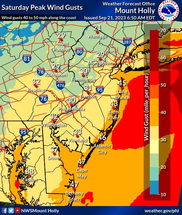
Gusty winds around 30 miles per hour will peak Saturday close to Philadelphia with gusts closer to 25 miles per hour in surrounding counties. Coastal flooding could also be a concern on Saturday with the expected rainfall, said forecasters.
And, high wind gusts will again make swimming conditions dangerous along Jersey Shore beaches, said the National Weather Service:
Find out what's happening in Across Pennsylvaniafor free with the latest updates from Patch.
“Besides the flooding rain potential… winds may gust up to 40 mph inland and 50 mph near the coast, which may result in coastal flooding, beach erosion and dangerous rip currents,” forecasters said. “Suffice it to say, the weekend in general, and Saturday in particular, is not looking very nice.”
Thursday and Friday are expected to be dry and seasonable, per the NWS. The exact timing of the system isn’t certain, but an initial batch of moderate-to-heavy rain will advance northward across the Delaware Peninsula on Friday night, and could be into the Philadelphia region by Saturday morning.
“These kinds of storm systems can often be slow-moving and notoriously difficult to forecast,” the NWS said Thursday.
“As far as sensible weather goes, look for sunshine to fade quickly across most of our region through midday Friday as high clouds spread northward.”
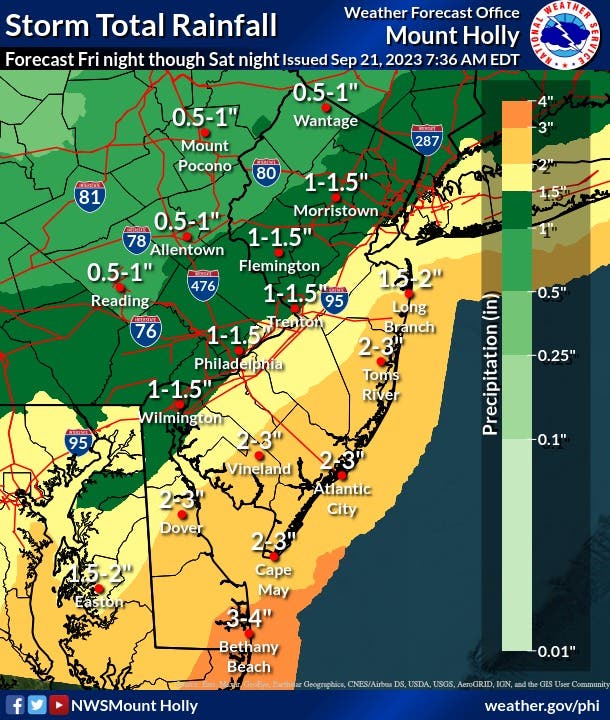
Total rainfall amounts from Friday night to Saturday night have decreased slightly from yesterday's outlook, but could change as the storm develops. Right now, the National Weather Service predicts between 1 and 1.5 inches of rain in Philadelphia and most of the surrounding counties.
Here is a look at the latest forecast for southeast Pennsylvania from the National Weather Service:
Thursday: Sunny, with a high near 74. North wind around 5 mph.
Thursday Night: Partly cloudy, with a low around 52. Northeast wind around 5 mph becoming calm.
Friday: Partly sunny, with a high near 73. East wind 5 to 15 mph.
Friday Night: A chance of rain after 3am. Mostly cloudy, with a low around 57. Northeast wind around 10 mph. Chance of precipitation is 40 percent. New precipitation amounts of less than a tenth of an inch possible.
Saturday: Rain, mainly after 9am. High near 64. Breezy, with a northeast wind 15 to 20 mph, with gusts as high as 30 mph. Chance of precipitation is 80 percent. New precipitation amounts between a half and three quarters of an inch possible.
Saturday Night: Rain likely. Cloudy, with a low around 57. Chance of precipitation is 70 percent. New precipitation amounts between a quarter and half of an inch possible.
Sunday: Rain likely, mainly before 9am. Mostly cloudy, with a high near 68. Chance of precipitation is 60 percent.
Sunday Night: A chance of rain before 9pm, then a chance of showers after 9pm. Mostly cloudy, with a low around 55. Chance of precipitation is 50 percent.
Get more local news delivered straight to your inbox. Sign up for free Patch newsletters and alerts.