Community Corner
Early April In Pa.: Polar Vortex, Snow Possible, Forecasters Predict
April is going to get of to a cold start — complete with a Polar vortex and the possibility of snow — according to forecasters.

April is going to get of to a cold start — complete with a Polar vortex and the possibility of snow — according to forecasters.
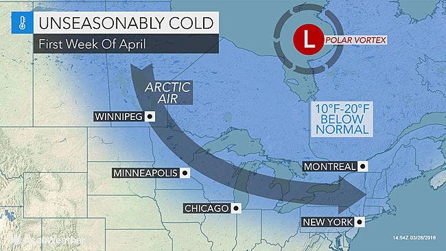
The polar vortex is expected to take a southward plunge, sending arctic air and even the potential for snow toward the northeastern United States, including Pennsylvania, during the first week of April, forecasters with AccuWeather predict.
The northern part of the mid-Atlantic is one area that will get a hefty dose of the cold air and temperatures will be "unseasonably cold," according to AccuWeather.
Find out what's happening in Lower Gwynedd-Ambler-Whitpainfor free with the latest updates from Patch.
RELATED: 6 Ways To Protect Your Plants From A Spring Freeze
"Temperatures in the Northeast will be 10-20 degrees Fahrenheit below normal, which will be the largest negative anomalies since Valentines Day," AccuWeather Meteorologist Joe Lundberg said. "When the wind is factored in, it will feel a whopping 40-60 degrees colder than it will late this week."
Find out what's happening in Lower Gwynedd-Ambler-Whitpainfor free with the latest updates from Patch.
Normal high temperatures for the region are typically in the upper 50s to 60s.
But next week won't be normal — the high temperature Sunday, Monday and Tuesday will be in the 40s, according to the National Weather Service. Low temperatures will be in the 20s Sunday, according to the forecast.
Snow showers could accompany the frigid weather, especially along the I-95 corridor, according to predictions by AccuWeather.
The National Weather Service also has a chance of snow in its 7-day forecast. The NWS says there's a chance of snow showers Monday and Tuesday.
Here is the local forecast:
Tonight: Partly cloudy, with a low around 41. South wind around 9 mph.
Thursday: Partly sunny, with a high near 70. Breezy, with a southwest wind 9 to 14 mph increasing to 15 to 20 mph in the afternoon. Winds could gust as high as 32 mph.
Thursday Night: Showers likely, then showers and possibly a thunderstorm after 2am. Low around 59. South wind 13 to 16 mph. Chance of precipitation is 80%. New rainfall amounts between a tenth and quarter of an inch, except higher amounts possible in thunderstorms.
Friday: Showers and possibly a thunderstorm. High near 70. Southwest wind around 14 mph. Chance of precipitation is 80%. New rainfall amounts between a quarter and half of an inch possible.
Friday Night: A slight chance of showers before 11pm. Mostly cloudy, with a low around 46. Chance of precipitation is 20%.
Saturday: Mostly sunny, with a high near 59.
Saturday Night: Partly cloudy, with a low around 35. Breezy.
Sunday: Mostly sunny, with a high near 46. Breezy.
Sunday Night: Mostly clear, with a low around 28.
Monday: Mostly sunny, with a high near 48.
Monday Night: A chance of rain and snow showers. Mostly cloudy, with a low around 32. Chance of precipitation is 30%.
Tuesday: A chance of rain and snow showers. Partly sunny, with a high near 48. Chance of precipitation is 30%.
Get more local news delivered straight to your inbox. Sign up for free Patch newsletters and alerts.