Health & Fitness
Winter Decides To Show Up
Winter decides to return as colder temperatures and perhaps some snow are in the cards for the region next week.
he cold front that crossed the region on Friday morning brought a merciful end to one of the warmer stretches of December on record for Philly. The first three weeks of this month have been the warmest we've seen since 2001, which was a winter that we can largely care to forget.
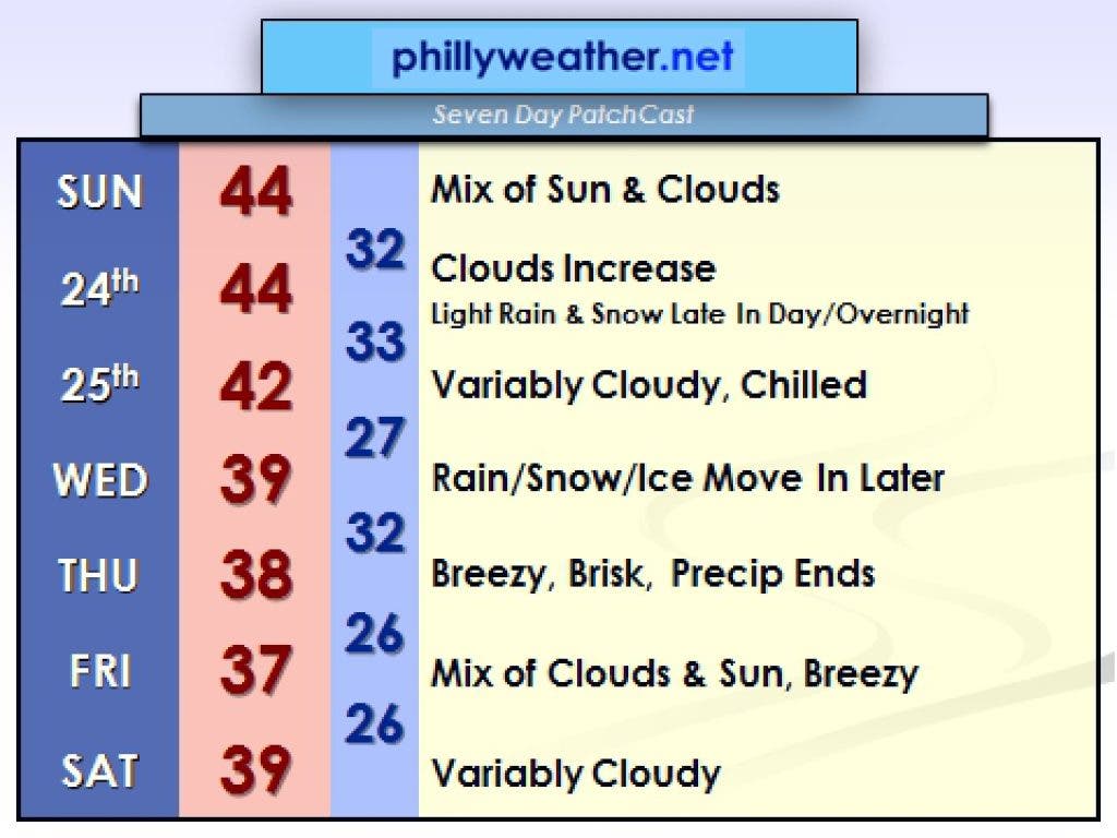
The good news for cold and snow lovers is that the upcoming week of weather will feature a couple of snow chances and perhaps the region's first Christmas snowfall in a while. Temperatures will also be much more typical for late December although the cold will not be record shattering or even arctic-like in nature. Instead of 50's and 60's, highs will be in the 30's and 40's for the next week.
The first of two potential snow events will be on Christmas Eve -- this is a relatively modest storm system compared to the larger storm that looms for later next week. As it stands now, the track of this storm is close enough to the region that precipitation could fall either as rain or snow, with better chances of snow the farther north and northwest one goes. If you're travelling to the Poconos or the Lehigh Valley, a few inches of snow are possible on Christmas Eve night. It looks as of now the city sees mostly rain from this but it's not a warm rain by any stretch as temperatures probably hang in the 30's or low 40's Christmas Eve evening as the storm moves through. If you're north and west of the city, the chances of snow will quickly increase.
Find out what's happening in Chestnut Hill-Mt. Airyfor free with the latest updates from Patch.
After this first system, a second and larger storm will head towards the region for Wednesday afternoon through early Thursday. This second storm will have more moisture to work with than the Christmas Eve system and will also be stronger. A mixed bag of precipitation is expected over the Mid Atlantic, with snow more likely across the Poconos and Central Pennsylvania, with rain likely along the coast. The big question five days out is what happens in between -- along I-95 and across Southeastern Pennsylvania? That is still rather uncertain since we'll again ride the proverbial temperature fence. In any event, know that this storm does look more likely for Wednesday afternoon into Thursday morning. Phillyweather.net will update details on it as best as we can through Christmas and up to the event.
Once this second storm moves through, a few days of quieter but seasonally cold weather will take over through the end of the week. Highs generally don't get much above freezing and lows look to be solidly in the 20's at night. After a lengthy repreive in chill, December finally decided to behave like its namesake in the weather department. It took long enough.
Find out what's happening in Chestnut Hill-Mt. Airyfor free with the latest updates from Patch.
____________________________________________________
Tom Thunstrom is the editor and publisher of Phillyweather.net. You can also follow Phillyweather.net on twitter at @phillywx or on Facebook.