Weather
Snow Estimates Released For Midweek Storm In Eastern Pennsylvania
The National Weather Service has released maps estimating the amount of snow that could fall during a Thursday morning storm.

The Philadelphia area may be spared from what forecasters predicted could have been a major storm later this week. The storm, expected in the area by early Thursday morning, is currently tracking far enough off the coast to have minimal impacts in Philadelphia and its suburbs, according to forecasters.
Forecasters from the National Weather Service and other agencies have released maps estimating the amount of snow that could fall after 1 a.m. on Thursday. The most recent estimates say we can expect just a couple of inches of snow if the storm continues on as predicted.
A Hazardous Weather Outlook has been issued across the area, including in Bucks, Chester, Montgomery, Delaware and Philadelphia counties, where one to two inches of snow is predicted.
Find out what's happening in Doylestownfor free with the latest updates from Patch.
According to meteorologists with Action News in Philadelphia, even though current models are suggesting the storm will pass off the coast, "even a slight shift west would bring higher amounts to everyone and possibly push the snow boundary farther north and west."
Parts of the Jersey Shore could see significant snowfall.
Find out what's happening in Doylestownfor free with the latest updates from Patch.
Here is the latest map:

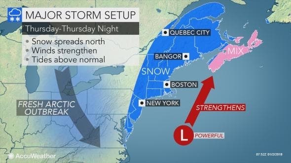
While the Philadelphia region may be largely spared, the storm will have both direct and indirect impacts from Florida to Maine and Atlantic Canada, according to AccuWeather. Arctic air will linger and even spread southward into Florida as the storm brews nearby over the Atlantic Ocean.
The heaviest snow from the storm will fall on Maine and New Brunswick, Canada, where a blizzard is forecast to unfold, according to an AccuWeather release.
Motorists and pedestrians should expect at least some blowing and drifting snow as far west as the Hudson Valley of New York, much of New Jersey, the Delmarva Peninsula and even a few areas just inland of the coast in the Southeast states, according to the release. Winds strong enough to trigger airline delays are likely in the major hubs of the Northeast, from Washington, D.C., to Philadelphia, New York City and Boston from Thursday to Friday.
Here is the forecast:
Today: Sunny, with a high near 23. West wind around 9 mph.
Tonight: Mostly clear, with a low around 11. West wind 5 to 8 mph.
Wednesday: Increasing clouds, with a high near 27. Light and variable wind becoming southwest around 5 mph.
Wednesday Night: Snow likely, mainly after 1am. Mostly cloudy, with a low around 18. Calm wind becoming north 5 to 8 mph after midnight. Chance of precipitation is 60%. New snow accumulation of less than one inch possible.
Thursday: Snow likely, mainly before 1pm. Mostly cloudy, with a high near 25. Northwest wind 11 to 15 mph, with gusts as high as 26 mph. Chance of precipitation is 60%. New snow accumulation of around an inch possible.
Thursday Night: Partly cloudy, with a low around 7.
PHOTO: NWS
Get more local news delivered straight to your inbox. Sign up for free Patch newsletters and alerts.