Weather
Historic Flooding Possible As Halloween Weekend Storm Approaches Eastern PA
Forecasters note "increasing concern" for tidal flooding, with the potential for historic crests in some areas. Here are the latest details:

PHILADELPHIA, PA — The powerful storm that is approaching the Philadelphia area entering Halloween weekend could bring near-record floods to some areas, forecasters note, with water levels already elevated from bouts of heavy rain earlier this week.
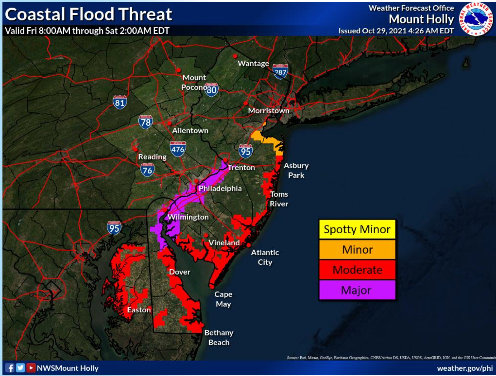
The risk is especially high in tidal waterways that will swell at high tide, with the Delaware River predicted to rise to historic heights in the aftermath of the storm. At Washington Street in Philadelphia, where the river was already flooded to about 8 feet Friday morning, a crest of 10.3 feet — considered "major flood stage" — is expected by Friday evening. The all-time record, from Superstorm Sandy in 2012, is 10.6 feet.
Stay in the know. Subscribe to Patch: https://patch.com/subscribe
Find out what's happening in Haverford-Havertownfor free with the latest updates from Patch.
Officials are warning residents to prepare for damage.
"At this level, flooding may become severe enough to cause some structural damage along with widespread roadway flooding near tidal waterways," the National Weather Service said. "Some locations may become isolated by the flood waters."
Find out what's happening in Haverford-Havertownfor free with the latest updates from Patch.
While rivers and creeks farther inland from the Delaware River will be elevated, severe flooding comparable to what was seen during Ida is not expected, according to forecasts.
A coastal flood warning is in place for Philadelphia, lower Bucks, and Delaware counties until 1 a.m. Saturday.
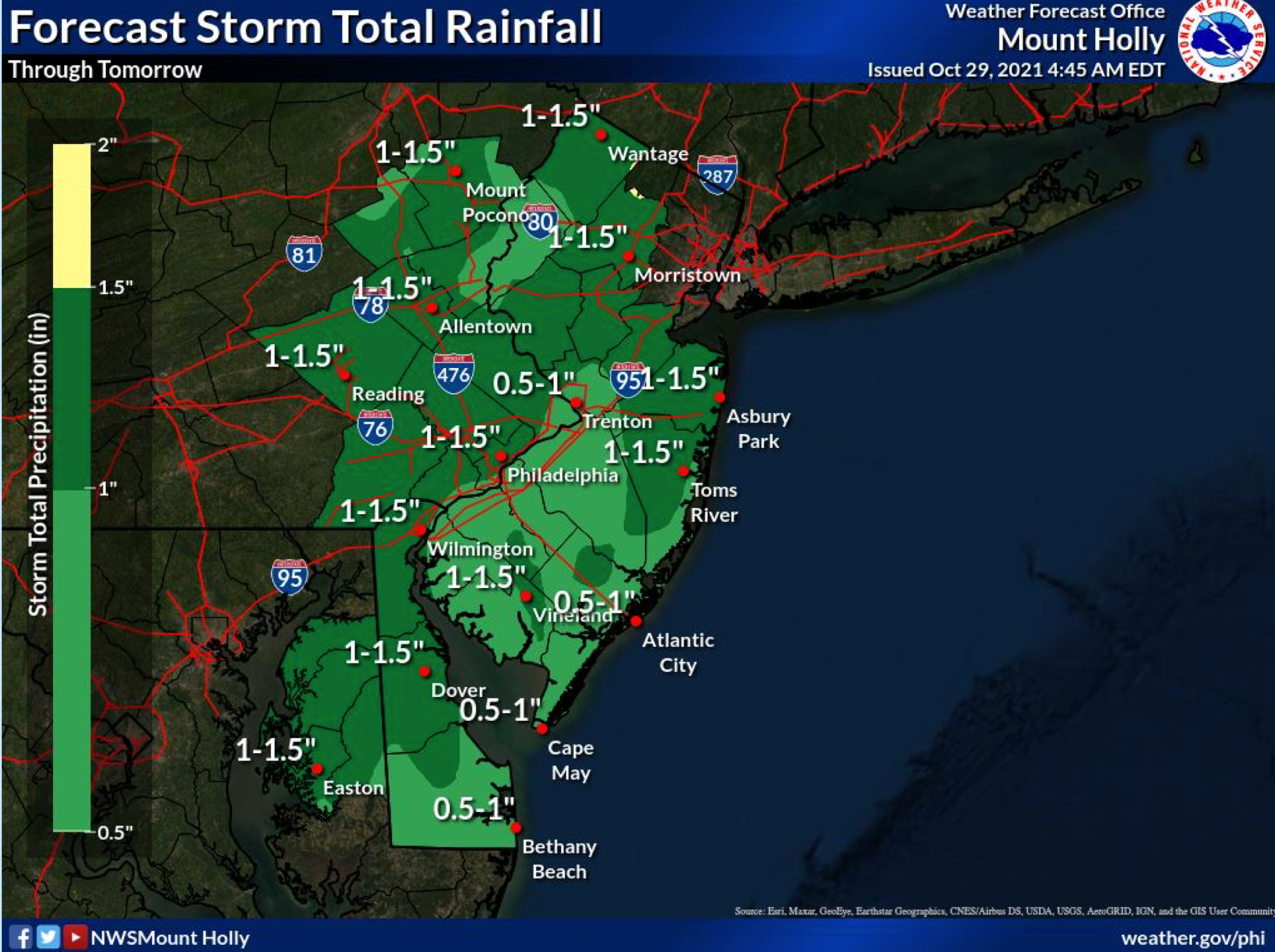
Rain is expected to begin early Friday afternoon and continue into the evening, with a total of an inch to an inch and a half of rain accumulating throughout most of southeastern Pennsylvania. Locally higher amounts are possible.
"Two to three feet of inundation above ground level expected in low-lying areas near shorelines and tidal waterways," the weather service adds.
Wind gusts of around 30 miles per hour are predicted in much of the five-county area.
The full forecast is included below:
Friday
Showers, mainly after 1 p.m. High near 59. Breezy, with an east wind 15 to 20 mph, with gusts as high as 30 mph. Chance of precipitation is 80 percent. New precipitation amounts between a quarter and half of an inch are possible.
Friday night
Showers, mainly before 2 a.m. Low around 56. Breezy, with an east wind 15 to 20 mph decreasing to 5 to 10 mph after midnight. Winds could gust as high as 30 mph. Chance of precipitation is 90 percent. New precipitation amounts between a half and three quarters of an inch are possible.
Saturday
Rain likely, mainly between 8 a.m. and 2 p.m., then showers likely after 2 p.m. Mostly cloudy, with a high near 63. South wind 5 to 10 mph. Chance of precipitation is 60 percent. New precipitation amounts of less than a tenth of an inch are possible.
Saturday night
Showers likely before 8 p.m. Mostly cloudy, with a low around 53. Southwest wind around 5 mph. Chance of precipitation is 60 percent. New precipitation amounts of less than a tenth of an inch are possible.
Sunday
Partly sunny, with a high near 61. Southwest wind 5 to 10 mph.
Sunday night
Mostly clear, with a low around 48.
Get more local news delivered straight to your inbox. Sign up for free Patch newsletters and alerts.