Community Corner
Next Half Of January To Be Snowy and Slick: Forecasters
Forecasters have released details on what's supposed to become a snowier and slicker January.

Tuesday evening’s dusting, which left many area roads slick, may just be the beginning of a snowy and icy month in Pennsylvania, forecasters say.
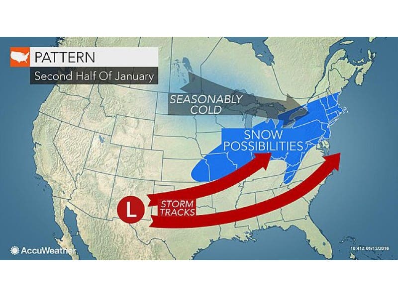
Enough cold air will linger across the region during the latter half of January to increase the chance of snow in areas that have received little so far this season, forecasters from AccuWeather said this week.
A complex storm could bring precipitation to the Philadelphia area this weekend, followed by another wave of arctic air that will sweep southeastward this weekend, according to AccuWeather.
Find out what's happening in Newtownfor free with the latest updates from Patch.
With the air starting colder as storms approach, the likelihood of precipitation beginning as snow or a wintry mix will be much greater during the second half of the month than at any point so far this season, AccuWeather says.
“In the Midwest, this new blast of arctic air will be as cold as that of the start of this week, but for much of the Northeast it will be coldest of the season so far,” AccuWeather Senior Meteorologist Brett Anderson says in the release.
Find out what's happening in Newtownfor free with the latest updates from Patch.
The storm system that is expected to take shape this weekend could saturate the region with rain, starting out and end as a sloppy mix of rain, sleet and snow, according to nj.com.
Even as the core of the arctic air settles off the coast over the next week or two, meanwhile, enough cold air may remain behind to allow storms that roll along have greater chances at bringing snow or some sort of wintry precipitation when compared to early winter.
“You don’t need bitterly cold air for it to snow, just cold enough, within a few degrees of freezing,” AccuWeather Chief Long-Range Meteorologist Paul Pastelok said in the release. “We expect temperatures to settle near average during late January in the Midwest and much of the East, which is cold enough for snow.”
While the exact timing and track of storms, which will determine who gets snow versus rain, can be uncertain several days out, there are indications that the pattern will yield more snow opportunities during late January, according to AccuWeather.
“If we look at the overall pattern, there is likely to be a major storm or two with a chance at bringing substantial accumulating snow to portions of the Ohio Valley, I-95 corridor of the mid-Atlantic and southern New England during the third and fourth week of the month,” Pastelok said.
Here is the current forecast for the next few days in the Philadelphia region, according to the National Weather Service:
Tonight: Partly cloudy, with a low around 20. West wind 5 to 8 mph.
Thursday: Partly sunny, with a high near 39. Light southwest wind becoming west 6 to 11 mph in the morning.
Thursday Night: Partly cloudy, with a low around 33. Southwest wind around 6 mph becoming calm in the evening.
Friday: A slight chance of rain after 1pm. Partly sunny, with a high near 48. Calm wind becoming south around 5 mph in the afternoon. Chance of precipitation is 20%.
Friday Night: Rain. Low around 39. Chance of precipitation is 80%. New precipitation amounts between a quarter and half of an inch possible.
Saturday: A chance of rain before 1pm. Mostly cloudy, with a high near 48. Chance of precipitation is 50%.
Saturday Night: Mostly cloudy, with a low around 30.
Get more local news delivered straight to your inbox. Sign up for free Patch newsletters and alerts.