Community Corner
Winter Weather Advisory Issued; Snow, Ice Expected
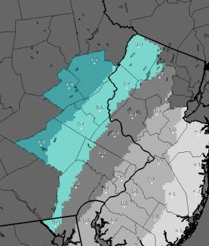
A Winter Weather Advisory begins Monday at 9 a.m. in Bucks, Chester, Delaware and Montgomery counties.

Brutal weekend cold will be followed by a “significant” winter storm Monday, forecasters with the National Weather Service say.
A winter storm will affect the region beginning Monday afternoon into Tuesday. A Winter Weather Advisory begins Monday at 9 a.m. and goes through Tuesday at 2 a.m.
Areas around Philadelphia, including Bucks, Chester, Delaware and Montgomery counties will likely see anywhere from one to four inches of snow. Snow will turn to rain by Monday evening. The rain may be heavy at times, causing the potential for flooding.
Find out what's happening in Newtownfor free with the latest updates from Patch.
Snow will begin by later morning and continue through the day, the National Weather Service says. “The snow will mix with sleet and then change to freezing rain Monday evening.” A “prolonged period” of freezing rain is anticipated before a full changeover to rain Tuesday morning.
Areas north of Philadelphia can expect more snow.
Find out what's happening in Newtownfor free with the latest updates from Patch.
“Significant amounts of snow and ice are possible, mainly north and west of Interstate 95. The Poconos, Lehigh Valley and Northwestern New Jersey will see precipitation stay as snow and ice the longest and have the highest accumulations,” the NWS said.
More than four inches of snow is possible in the Lehigh Valley in these areas with up to ¼ inch of ice before the switchover to rain.
The storm follows single-digit temperatures overnight, and a wind chill advisory that expired Sunday morning.
Here is the forecast:
Today: Sunny, with a high near 16. Wind chill values as low as -10. Northwest wind 8 to 11 mph.
Tonight: Increasing clouds, with a low around 11. West wind around 5 mph becoming calm in the evening.
Monday: Snow after 8am, mixing with sleet after 4pm. High near 35. Calm wind becoming southeast around 6 mph in the afternoon. Chance of precipitation is 80%. New snow and sleet accumulation of 1 to 2 inches possible.
Monday Night: Rain, snow, and sleet, becoming all rain after 8pm. Low around 35. South wind 5 to 7 mph. Chance of precipitation is 90%. New snow and sleet accumulation of less than one inch possible.
Tuesday: Rain. The rain could be heavy at times. High near 49. South wind 10 to 14 mph. Chance of precipitation is 90%. New precipitation amounts between three quarters and one inch possible.
Tuesday Night: A chance of rain showers before 4am, then a chance of snow showers. Mostly cloudy, with a low around 31. Chance of precipitation is 30%. New precipitation amounts of less than a tenth of an inch possible.
Wednesday: A chance of snow showers before 7am. Partly sunny, with a high near 44. Chance of precipitation is 30%.
Wednesday Night: Partly cloudy, with a low around 25.
Get more local news delivered straight to your inbox. Sign up for free Patch newsletters and alerts.