Weather
Timing, Latest Track For Weekend Snowstorm In Eastern PA
The latest information on the timing and track of a winter storm expected to impact Eastern Pennsylvania this weekend.

Forecasters have provided additional insight into a "significant" winter storm expected to impact Eastern Pennsylvania and the entire Northeast region this weekend.
The National Weather Service has declared a Winter Storm Watch in parts of Eastern Pennsylvania, including in Upper Bucks and Western Montgomery counties, as well as in Northampton, Berks, Carbon, Monroe, and Lehigh counties.
The storm, which will start Saturday, will come with a variety of precipitation types and impacts, including snow, sleet and ice.
Find out what's happening in Newtownfor free with the latest updates from Patch.
In the northeastern part of the state, a period of heavy snowfall will likely occur late Saturday. The precipitation will change over to sleet and ice overnight, and "very hazardous" travel
conditions are anticipated.
Gov. Tom Wolf on Friday declared a state of emergency in advance of the storm.
Find out what's happening in Newtownfor free with the latest updates from Patch.
"Power outages may also be possible due to a combination of strong winds and ice," the Winter Storm Watch said.
Further south in Pennsylvania, residents can expect heavy rainfall instead of snow and sleet. Exactly where that transition line will fall is not clear at this point.
"Near and along the I-95 corridor, a small shift in the storm track could result in big differences in precipitation type and amount," the NWS said.
RELATED: Snow Estimates For 2 Storms, But Ice Likely Bigger Threat In PA
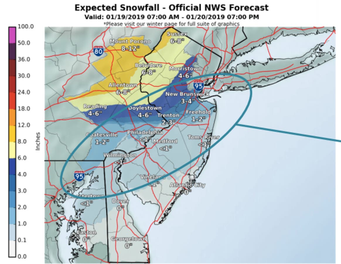
Current predictions are for Philadelphia and areas south to get an inch or less of snow. Suburbs to the north and west could see 2 to 3 inches. In Upper Bucks County and Western Montgomery County, up to 6 inches is possible, according to NWS predictions.

In areas where rain falls, urban and river flooding is possible. "Flooding potential is largely dependent on how much precipitation falls as rain as opposed to ice and snow," the NWS said in a Friday morning update.
Then Sunday afternoon, a "rapid" temperature drop will lead to a hard freeze of any areas of slush and standing water, even for areas that received little to no snowfall, the NWS said. "This will lead to very icy conditions Sunday evening and overnight. Bitterly cold air will make clearing snow and ice very difficult," the agency warns.
Additionally, strong winds are predicted late Sunday through Monday and could cause localized power outages.
Temperatures will plummet to single digits overnight Sunday and Monday.
A warm up with highs in the mid-40s is expected by Wednesday.
Check back for updates.
Get more local news delivered straight to your inbox. Sign up for free Patch newsletters and alerts.


