Weather
Timing, Snowfall Estimates For Wednesday Storm In Eastern PA
Ready for the next round? Here's what you can expect in terms of timing and likely snowfall accumulation for Wednesday:


The next round of winter weather is on its way to Eastern Pennsylvania, and will bring as much as five inches of snow and a glaze of ice on Wednesday.
The National Weather Service has issued a Winter Storm Watch for the Philadelphia region from 7 a.m. to 9 p.m. Wednesday. According to the NWS, heavy mixed precipitation is possible, with total snow accumulations between 3 to 5 inches. A light glaze of ice is also possible.
Drivers should plan on slippery road conditions during the storm. Some districts, including the School District of Philadelphia, have already announced school closures for Wednesday.
Find out what's happening in Newtownfor free with the latest updates from Patch.
TIMING
According to The Weather Channel, snow showers will begin late morning. By noon, snowfall will begin falling more steadily and stay that way through the afternoon, until turning to rain by nightfall, according to The Weather Channel.
Find out what's happening in Newtownfor free with the latest updates from Patch.
Temperatures are expected to rise through the afternoon and evening. By midnight, we can expect a high of 38 degrees, forecasters predict. Rain showers will continue through the early morning hours, making way to cloudy skies by daybreak Thursday.
ACCUMULATION
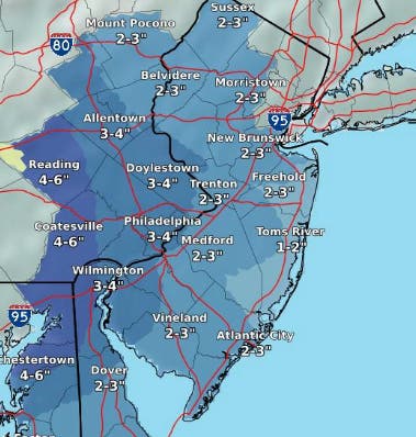
Snowfall accumulation predictions range from 3 to 5 inches, with most Philadelphia suburbs to the south and north getting about 3. Some areas west, including parts of Chester County, could see closer to 5, the NWS said.
The following map of snowfall accumulations for the Wednesday storm was released by the NWS just before 3 p.m. Tuesday:
A light glaze of ice is also possible.
The switchover from snow to rain will also vary by location. Areas north can expect that switchover to occur later in the evening, and may include a duration of rain mixed with ice. Closer to Philadelphia, the switchover is predict to happen around 5 p.m., according to The Weather Channel.
The system is currently moving over the Midwest, where there have been reports of "thundersnow." Snow will then pivot towards the northern Great Lakes before arriving in the mid-Atlantic and Northeast.
Washington D.C., Baltimore and Philadelphia metros will see accumulating snow as a result of this system. New York City could see a couple inches of snow Wednesday afternoon it changes to rain on Wednesday night. "The snow may impact the afternoon commute in the tri-state area," The Weather Channel said in a Tuesday update.
From New York, the storm will move on to New England, where some snow could fall before a full transition to rain.
Meanwhile, expect temperatures to warm up later in the week. The high temperature on Thursday will be in the mid-50s.
Here is the forecast:
Tonight: Increasing clouds, with a low around 24. North wind around 5 mph becoming calm in the evening.
Wednesday: Snow, mainly after 10am. High near 33. East wind 5 to 8 mph. Chance of precipitation is 90%. New snow accumulation of 2 to 4 inches possible.
Wednesday Night: Rain and sleet, becoming all rain after 10pm. Low around 32. East wind 6 to 9 mph. Chance of precipitation is 90%. New sleet accumulation of less than one inch possible.
Thursday: Rain, mainly before 7am. High near 56. Light west wind increasing to 8 to 13 mph in the morning. Chance of precipitation is 80%. New precipitation amounts of less than a tenth of an inch possible.
Thursday Night: Mostly cloudy, with a low around 32. Northwest wind 6 to 10 mph.
Friday: Partly sunny, with a high near 47.
Friday Night: Mostly cloudy, with a low around 31.
Saturday: A chance of rain. Mostly cloudy, with a high near 46. Chance of precipitation is 40%.
Image via NWS
Get more local news delivered straight to your inbox. Sign up for free Patch newsletters and alerts.