Weather
Major Storm Could Hit PA With High Winds, Possible Flooding
A big storm coming from the South could hit eastern Pennsylvania this week and act like a nor'easter.

A big storm could be heading Pennsylvania's way and make a mess of things on the roads, impact playing fields and change travel plans as many prepare for spring break.
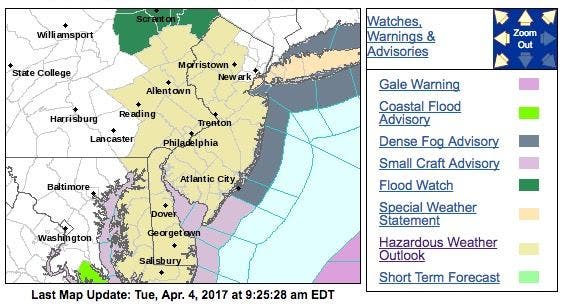
The National Weather Service has issued a hazardous weather outlook for eastern Pennsylvania, saying there is risk for flooding because of "heavy rain increases" on Wednesday night and Thursday.
The storm could stall and behave like a nor'easter, churning up the coastline with strong winds and rain.
Find out what's happening in Norristownfor free with the latest updates from Patch.
A flood watch may be issued because minor tidal flooding is possible with the Thursday afternoon high tide. The primary hazard for any storms would be strong winds, according to the NWS.
Find out what's happening in Norristownfor free with the latest updates from Patch.
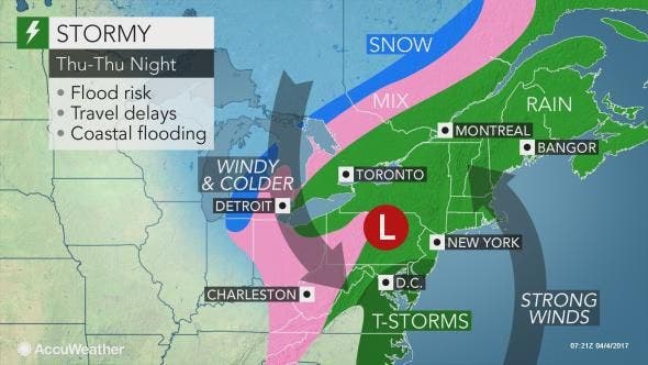
The storm has the potential to be the strongest in a series to hit the Northeast since late March and through the first week of April, AccuWeather Senior Meteorologist Brett Anderson said in a release.
The storm could have damaging consequences in terms of severe thunderstorms, powerful wind gusts and flooding from heavy rain and above-normal tides, according to AccuWeather.
As the storm approaches the Northeast states, it will reorganize near the coast and stall.
The storm will raise risk of urban, small stream and river flooding, according to AccuWeather.
The slow forward motion of the storm and a surge of warm air along the Atlantic coast will result in a prolonged rain event for some areas that can escalate runoff and lead to flooding, according to AccuWeather.
Here is the NWS weather forecast:
- Tuesday: Scattered showers and thunderstorms. Some of the storms could produce gusty winds. Mostly cloudy, with a high near 71. Southwest wind 8 to 10 mph. Chance of precipitation is 50 percent. New rainfall amounts between a tenth and quarter of an inch, except higher amounts possible in thunderstorms.
- Tuesday night: Partly cloudy, with a low around 50. West wind 9 to 13 mph.
- Wednesday: Sunny, with a high near 67. West wind 6 to 11 mph.
- Wednesday night: Showers likely, mainly after 4 a.m. Increasing clouds, with a low around 47. East wind 9 to 15 mph. Chance of precipitation is 60 percent. New precipitation amounts between a tenth and quarter of an inch possible.
- Thursday: Showers and possibly a thunderstorm. Some of the storms could produce heavy rainfall. High near 58. Breezy, with an east wind 21 to 23 mph. Chance of precipitation is 90 percent. New rainfall amounts between 1 and 2 inches possible.
- Thursday night: A chance of showers and thunderstorms. Mostly cloudy, with a low around 43. Chance of precipitation is 30 percent. New precipitation amounts between a quarter and half of an inch possible.
- Friday: A chance of showers. Mostly cloudy, with a high near 53. Chance of precipitation is 30 percent.
Patch file photo
Get more local news delivered straight to your inbox. Sign up for free Patch newsletters and alerts.