Community Corner
Snow In Pa. Weekend Forecast As Miserable Weather Continues
If April showers bring May flowers, what does April snow bring? Lots of frustrated people who want to winter to be over.

If April showers bring May flowers, what does April snow bring?
In what is turning out to be a downright miserable start to the month weather-wise, forecasters predict a chance of snow in Pennsylvania this weekend. Once that clears we can expect steady rain early next week, according to predictions from the National Weather Service.
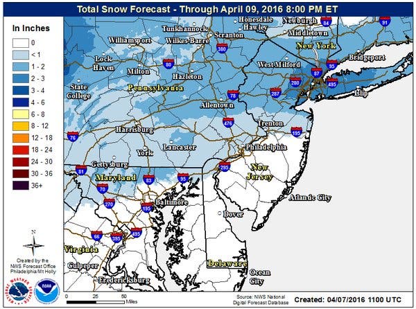
The National Weather Service says nearly all of Pennsylvania could get some snow Friday night into Saturday. A lot of accumulation is not expected but if the forecast pans out, we could see a white coating on the ground by Saturday night. Snow could mix with rain for slushy mess, according to AccuWeather forecasts.
Current accumulation estimates from the NWS are as follows:
- Philadelphia region: Less than one inch
- Lehigh Valley: one to two inches
- Pittsburgh region: one to two inches
- Some parts of western Pennsylvania could see up to four inches. View map here.
Oh, and there is snow in the forecast for Saturday. #WishThatWasAnAprilFoolsJokeButNot pic.twitter.com/KbjRUkz1Q0
— Gary Szatkowski (@GarySzatkowski) April 7, 2016
Skies will clear Sunday but it will be cold. A high of just 47 is predicted in the Philadelphia region.
Then early next week, it's rain rain rain — at least Monday and Tuesday.
Here is the forecast for the Philadelphia region:
Today: Showers and possibly a thunderstorm. High near 58. Southwest wind around 17 mph, with gusts as high as 28 mph. Chance of precipitation is 100%. New rainfall amounts between a quarter and half of an inch possible.
Tonight: Showers likely, mainly before 8pm. Cloudy, with a low around 41. West wind 8 to 11 mph. Chance of precipitation is 60%. New precipitation amounts between a tenth and quarter of an inch possible.
Friday: Partly sunny, with a high near 50. West wind 11 to 16 mph.
Friday Night: A chance of rain and snow between 2am and 3am, then a chance of snow after 3am. Mostly cloudy, with a low around 30. West wind 6 to 10 mph becoming southeast after midnight. Chance of precipitation is 30%. Little or no snow accumulation expected.SaturdayRain and snow likely, becoming all rain after 11am. Mostly cloudy, with a high near 43. Northwest wind 6 to 16 mph, with gusts as high as 31 mph. Chance of precipitation is 60%. New snow accumulation of less than a half inch possible.
Saturday Night: Snow likely, mainly before 8pm. Mostly cloudy, with a low around 25. Blustery. Chance of precipitation is 60%.
Sunday: Sunny, with a high near 47.Sunday NightMostly cloudy, with a low around 34.
Monday: A chance of rain after 8am. Mostly cloudy, with a high near 59. Chance of precipitation is 40%.
Monday Night: A chance of rain after 2am. Mostly cloudy, with a low around 51. Chance of precipitation is 40%.
Tuesday: Rain likely. Cloudy, with a high near 62. Chance of precipitation is 60%.
Tuesday Night: A chance of rain. Mostly cloudy, with a low around 39. Chance of precipitation is 40%.
Get more local news delivered straight to your inbox. Sign up for free Patch newsletters and alerts.