Kids & Family
Brief Relief From Heat Before Toasty Friday
We start out nice, if not cool depending on one's tastes, before the prospect of more 90s for the latter half of the week.
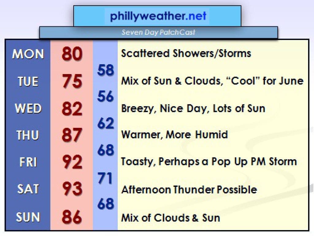
Last week's first official heat wave was rather intense, as temperatures reached the middle 90s for three consecutive days. While thunderstorms missed a number of locations in the outer western and northern suburbs on Friday, other locations were drenched with heat-busting relief that allowed us to enjoy a very nice weekend.
That niceness gets reinforced with a cool front crossing our region on Monday, although a price will be paid with some showers and storms accompanying the frontal passage through the region. Tuesday and Wednesday are shaping up to be nice days, with a relatively cool Tuesday, by late June standards. High temperatures are unlikely to top 80 degrees.
There could be showers near Allentown and in the Poconos, thanks to cool air becoming agitated by June sunshine, but those shower chances are somewhat limited and not widespread. Wednesday will be a bit warmer but also sunnier, arguably the nicest day of the upcoming week.
Find out what's happening in Plymouth-Whitemarshfor free with the latest updates from Patch.
As that cool air aloft retreats later in the week, heat and humidity build back in. This heat ridge has been percolating over the weekend across the Great Plains and will get a shove east through the course of the week. Some of the more aggressive computer modeling suggests 90 degrees is possible as soon as Thursday.
I didn't put that in the forecast at this point, since it is a bit of an outlier, but we could get pretty close by Thursday afternoon. Friday and Saturday look toasty regardless, as temperatures get into the lower or mid-90s on both days. Along with the heat comes a chance of thunderstorms both days.
Find out what's happening in Plymouth-Whitemarshfor free with the latest updates from Patch.
Saturday poses a higher threat for thunderstorms than Friday, at this point, as a frontal boundary tries to slip through Philadelphia. That front struggles to completely clear the area, though, and we could see thunderstorm chances continue into Sunday and in the days running up to the Fourth of July.
As for the Fourth, odds don't favor excessive heat, but with next weekend's frontal boundary perhaps lingering in the area we could see a chance of thunderstorms. Thankfully, there's a good bit of time between now and next Wednesday so the outlook may very well change.
Tom Thunstrom is the editor and publisher of Phillyweather.net. You can also follow Phillyweather.net on twitter at @phillywx or on Facebook.