Community Corner
6 to 12 Inches of Snow Possible through Monday
The forecast for the storm on Monday keeps nudging the snowfall totals up.

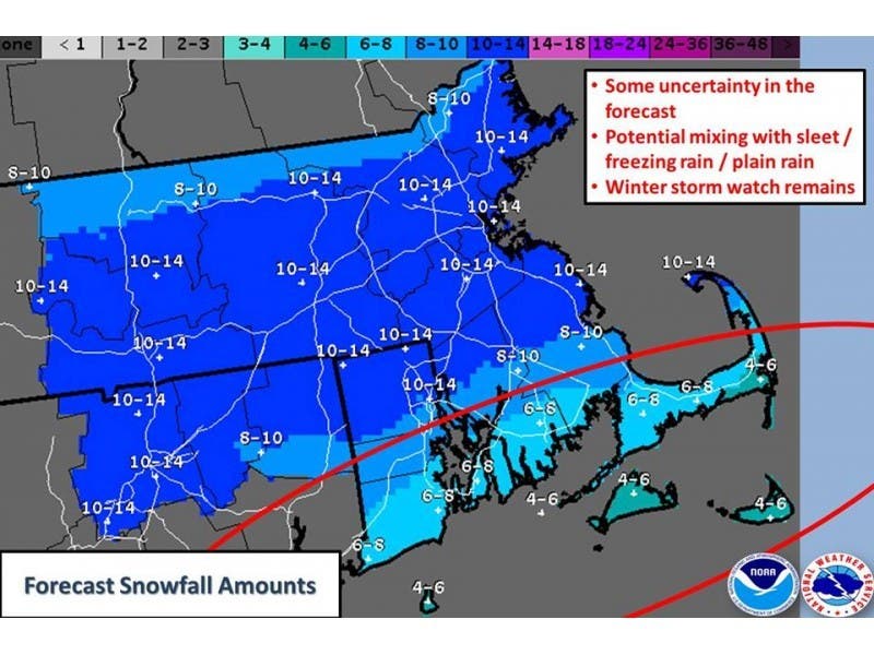
The latest forecast from the National Weather Service has upped the potential snowfall expected to hit the area late Sunday night.
Five to nine inches of snow will accumulate by Monday, NWS said. The snow is expected to impact the morning and evening commutes. The wind chill could drop as low as 25 below zero.
This will be the third major snowstorm to hit the region in the last week.
Find out what's happening in Newportfor free with the latest updates from Patch.
Here’s more from NWS:
- A WINTER STORM WATCH REMAINS IN EFFECT FROM SUNDAY EVENING THROUGH LATE MONDAY NIGHT...
- LOCATIONS...SOUTH COASTS OF BOTH MASSACHUSETTS AND RHODE ISLAND AS WELL AS CAPE COD.
- HAZARD TYPES...HEAVY SNOW ALONG WITH A PERIOD OF SLEET AND FREEZING RAIN POSSIBLE.
- ACCUMULATIONS...SNOW ACCUMULATION OF 5 TO 9 INCHES...ALONG WITH A TRACE OF ICE ACCRETION POSSIBLE.
- TIMING...SNOW DEVELOPS AFTER MIDNIGHT SUNDAY NIGHT. SNOW FALLS HEAVY AT TIMES MONDAY MORNING AT THE RATE OF 1 TO 2 INCHES PER HOUR AND IMPACTS THE MORNING RUSH HOUR. SNOW MAY MIX WITH AND CHANGE TO A PERIOD OF SLEET AND FREEZING RAIN FOR A TIME LATE MONDAY MORNING AND AFTERNOON. PRECIPITATION MAY CHANGE TO A PERIOD OF ALL RAIN ACROSS PORTIONS OF CAPE COD. ANY MIXED PRECIPITATION SHOULD CHANGE BACK TO SNOW MONDAY EVENING BEFORE ENDING.
- WINDS...NORTHEAST 20 TO 30 MPH WITH GUSTS UP TO 50 MPH. HAZARDOUS TRAVEL IS EXPECTED ALONG WITH SNOW COVERED ROADS AND POOR VISIBILITY. BLOWING AND DRIFTING SNOW ALSO EXPECTED.
- WINDS...NORTHEAST 20 TO 30 MPH WITH GUSTS UP TO 50 MPH.
Find out what's happening in Newportfor free with the latest updates from Patch.
Get more local news delivered straight to your inbox. Sign up for free Patch newsletters and alerts.