Weather
RI Weather: Freezing Rain, Snow, Sleet To Make For Messy Tuesday
Another bout of winter weather is expected to make for a slippery morning commute in Rhode Island.

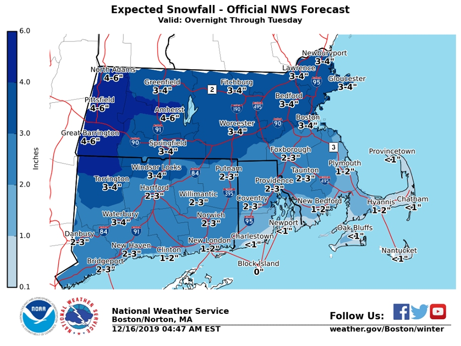
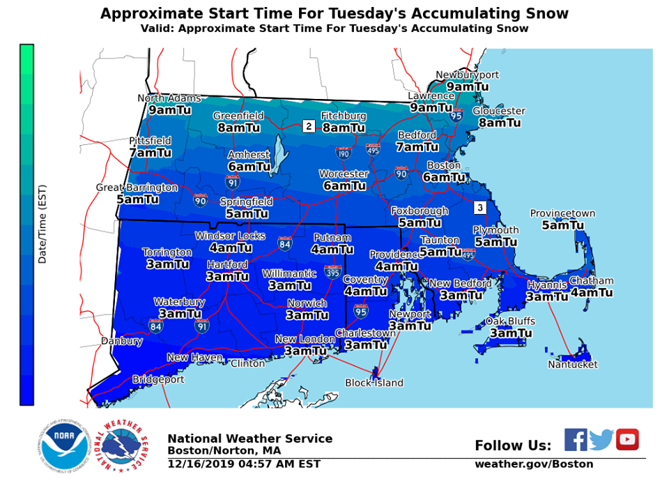
RHODE ISLAND — Here we go again. Another round of winter weather has taken aim at Southern New England, with snow, sleet and freezing rain in the forecast for Rhode Island and much of Massachusetts Monday night into Tuesday morning. As much as three inches of snow could fall in the northern part of the state, while coastal areas will likely see less than an inch of accumulation.
A big concern with this storm will be icing on roads, leading to a slippery morning commute. The National Weather Service has issued a winter weather advisory for much of the state from 1 a.m. until 1 p.m. on Tuesday.
"Plan on slippery road conditions," the advisory said. "The hazardous conditions could impact the morning commute."
Find out what's happening in Newportfor free with the latest updates from Patch.
Accumulating snow is expected to start falling in Rhode Island early Tuesday morning before turning into freezing rain and sleet that will likely last until around 1 p.m. The bottom line: expect slick roads when heading into work on Tuesday morning.
Here's a look at this week's latest forecast for Rhode Island from the National Weather Service.
Find out what's happening in Newportfor free with the latest updates from Patch.
Monday
Mostly cloudy, with a high near 38. West wind 6 to 8 mph.
Tonight
Snow, mainly after midnight. Low around 29. Calm wind becoming east around 6 mph after midnight. Chance of precipitation is 100 percent. New snow accumulation of 1 to 2 inches possible.
Tuesday
Rain, snow, freezing rain, and sleet before 1 p.m., then rain between 1 p.m. and 5 p.m., then rain and sleet likely after 5 p.m. High near 34. Northeast wind 7 to 9 mph. Chance of precipitation is 100 percent. New snow and sleet accumulation of less than one inch possible.
Tuesday Night
Rain, snow, freezing rain, and sleet likely before 9 p.m., then a chance of snow between 9 p.m. and 3 a.m. Cloudy, then gradually becoming partly cloudy, with a low around 27. North wind 8 to 13 mph. Chance of precipitation is 60 percent. Little or no snow and sleet accumulation expected.
Wednesday
Mostly sunny, with a high near 37. West wind 6 to 8 mph.
Wednesday Night
A slight chance of snow showers before 9 p.m. Partly cloudy, with a low around 14. Northwest wind 9 to 16 mph, with gusts as high as 28 mph. Chance of precipitation is 20 percent.
Thursday
Sunny, with a high near 23. Northwest wind around 17 mph, with gusts as high as 28 mph.
Thursday Night
Mostly clear, with a low around 14. Northwest wind 9 to 14 mph.
Friday
Sunny, with a high near 30. Northwest wind around 8 mph.
Get more local news delivered straight to your inbox. Sign up for free Patch newsletters and alerts.