Weather
RI Weekend Weather: Flood Watch In Place Ahead Of Heavy Rain
Heavy rain is expected across Rhode Island heading into the weekend, bringing the potential for flooding.


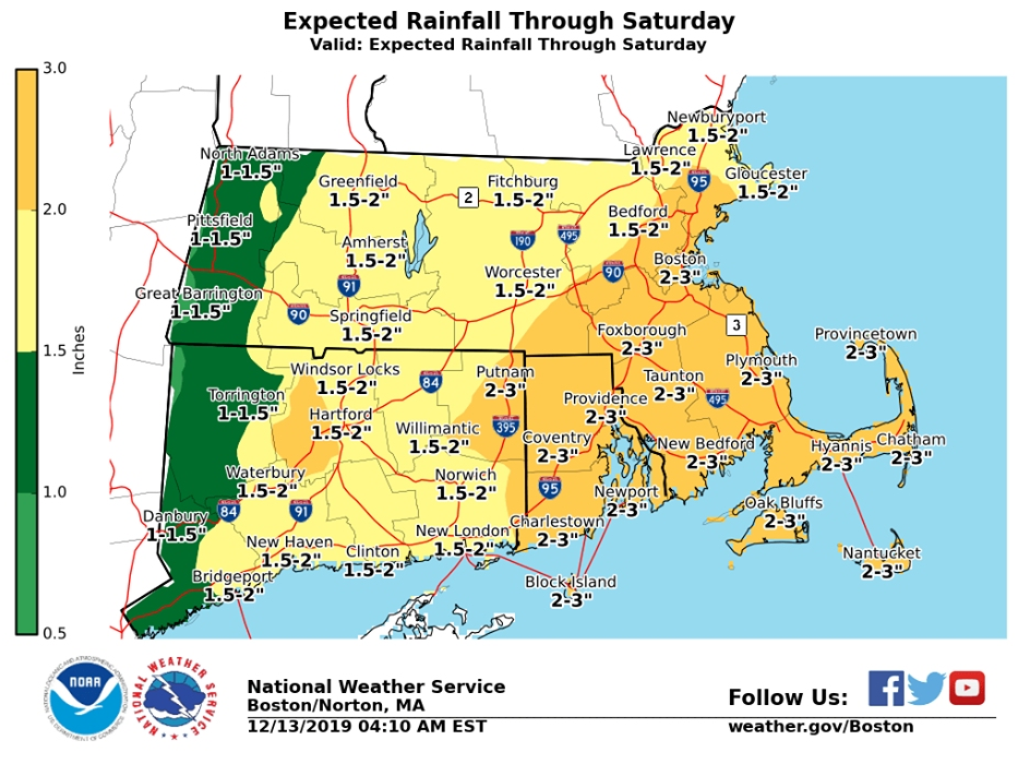
RHODE ISLAND — A flood watch has been issued for all of Rhode Island this weekend, ahead of heavy rain. Up to three inches of rain could fall across the state from Friday night into Saturday.
The rain will begin on Friday evening, with as much as two inches of rain falling throughout the night. More rain is in the forecast for Saturday, when up to another inch of rain is expected to fall throughout the day. Periods of heavy rain and fog are likely.
With so much rain in the forecast, any leftover snow still piled up from Wednesday's storm isn't likely to stick around.
Find out what's happening in Newportfor free with the latest updates from Patch.
Here's a look at the latest weather forecast from the National Weather Service.
Friday
A chance of showers after 3 p.m. Cloudy, with a high near 43. Southeast wind around 8 mph. Chance of precipitation is 30 percent.
Find out what's happening in Newportfor free with the latest updates from Patch.
Friday Night
Rain. The rain could be heavy at times. Areas of fog. Low around 41. East wind 8 to 10 mph. Chance of precipitation is 100 percent. New precipitation amounts between 1 and 2 inches possible.
Saturday
Rain. The rain could be heavy at times. Areas of fog. High near 57. Southeast wind 8 to 11 mph becoming southwest in the morning. Winds could gust as high as 26 mph. Chance of precipitation is 100 percent. New precipitation amounts between three quarters and one inch possible.
Saturday Night
A chance of rain, mainly before 11 p.m. Areas of fog before 2 a.m. Otherwise, mostly cloudy, with a low around 40. South wind 11 to 14 mph becoming west after midnight. Winds could gust as high as 25 mph. Chance of precipitation is 30 percent. New precipitation amounts of less than a tenth of an inch possible.
Sunday
Mostly sunny, with a high near 46. West wind 14 to 18 mph, with gusts as high as 31 mph.
Sunday Night
Partly cloudy, with a low around 28. West wind 10 to 14 mph.
Monday
Mostly sunny, with a high near 37. West wind around 8 mph.
Monday Night
Snow likely before 3 a.m., then snow and sleet likely. Patchy fog after 11 p.m. Otherwise, mostly cloudy, with a low around 29. West wind around 5 mph becoming calm. Chance of precipitation is 70 percent.
Tuesday
Freezing rain and sleet likely before 7 a.m., then freezing rain likely between 7 a.m. and 8 a.m., then rain likely after 8 a.m. Patchy fog between 1 p.m. and 2 p.m. Otherwise, cloudy, with a high near 42. Northeast wind around 7 mph. Chance of precipitation is 70 percent.
Tuesday Night
A chance of rain before 8 p.m. Patchy fog between 8 p.m. and midnight. Otherwise, mostly cloudy, with a low around 26. Northwest wind around 7 mph. Chance of precipitation is 30 percent.
Wednesday
Mostly sunny, with a high near 37. West wind 7 to 13 mph.
Wednesday Night
Partly cloudy, with a low around 17. West wind 11 to 13 mph, with gusts as high as 24 mph.
Thursday
Mostly sunny, with a high near 30. West wind around 11 mph.
Get more local news delivered straight to your inbox. Sign up for free Patch newsletters and alerts.