Weather
Flood Watch Issued For DC, Virginia Through Early Thursday: NWS
The National Weather Service issued a flood watch for Washington, D.C., Northern Virginia and the Fredericksburg area until 4 a.m. Thursday.

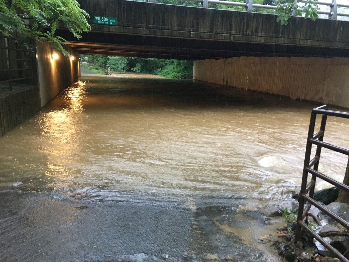
VIRGINIA/DC — The National Weather Service issued a flood watch for Washington, D.C., Northern Virginia and the Fredericksburg area until 4 a.m. Thursday, with rainfall rates of 2 inches per hour possible in some areas.
Excessive runoff may result in the flooding of rivers, creeks, streams, and other low-lying and flood-prone locations, the NWS said in an alert issued Wednesday afternoon.
Numerous showers and thunderstorms with heavy rain are expected in D.C. and Virginia through Wednesday night and into early Thursday morning, leading to the potential for flash flooding, especially in areas that see multiple rounds of heavy rain.
Find out what's happening in Arlingtonfor free with the latest updates from Patch.
A few of the storms may be severe, "unleashing damaging wind gusts and hail," The Washington Post's Capital Weather Gang said Wednesday afternoon.
Multiple waves of downpours are possible, with the first coming by 10 p.m. and at least one or two more rounds, according to the Capital Weather Gang.
Find out what's happening in Arlingtonfor free with the latest updates from Patch.
"Rainfall totals may average just 0.5 to 1 inch, but amounts could reach 2 to 3 inches in a few areas, falling over a short duration," the forecasters said.
Residents in D.C. and Virginia should monitor forecasts Wednesday night and be prepared to take action if a flash flood warning is issued, according to the NWS.
NBC4 meteorologist Chuck Bell said the storms forming over the area over the next few hours pose a risk of heavy rain. The primary threat "will be localized flash flooding," Bell said.
The storms will add to the heavy rainfall that the D.C. area has already received over the past few weeks. D.C. received 161 percent of its normal rainfall in May, according to AccuWeather.
Here's the NWS forecast for D.C. and the Virginia suburbs for the next few days:
Wednesday night: Showers and thunderstorms before 2 a.m., then showers and possibly a thunderstorm, mainly after 2 a.m. Some of the storms could produce heavy rain. Low around 69. Southeast wind 6 to 10 mph.
Thursday: Showers likely and possibly a thunderstorm before 8 a.m., then a chance of showers and thunderstorms between 8 a.m. and 11 a.m. Mostly cloudy through mid-morning, then becoming sunny, with a high near 83. Southwest wind 10 to 14 mph becoming northwest in the afternoon. Winds could gust as high as 23 mph.
Thursday night: Mostly clear, with a low around 60.
Friday: Mostly sunny, with a high near 82.
Friday night: Showers likely, mainly after 2 a.m. Mostly cloudy, with a low around 63.
Saturday: Showers likely, with thunderstorms possible after 2 p.m. Mostly cloudy, with a high near 73.
Get more local news delivered straight to your inbox. Sign up for free Patch newsletters and alerts.