Weather
NoVA, DC Weather: 103-Degree Heat Index Will Bake Region
Relief from 103-degree or more feels-like temperatures won't come until rains cool the DC/NoVA region. A heat emergency is in effect in DC.

VIRGINIA — Back-to-back triple-digit scorchers will kick off the work week in northern Virginia and DC, which prompted Mayor Muriel Bowser to issue a heat emergency for the city.
The heat index, or feels-like temperature when heat and humidity combine, could reach 103 degrees both Monday and Tuesday, according to the National Weather Service.
Hot and humid conditions likely will continue through the early week because of an offshore high pressure system known as a Bermuda high, meteorologists say. Forecast highs in the Northern Virginia-DC region will reach the mid-90s Monday and Tuesday, with a 20 to 30 percent chance of rain through Tuesday night.
Find out what's happening in Arlingtonfor free with the latest updates from Patch.
"While the first half of the week will bring stifling heat and humidity to much of the East Coast, a cold front will begin to make some progress to the south and east starting Wednesday," said AccuWeather Senior Meteorologist Carl Babinski on Monday.
A heat emergency has been activated for the District, Bowser's office tweeted Monday.
Find out what's happening in Arlingtonfor free with the latest updates from Patch.
Residents should stay hydrated, limit sun exposure, and check on seniors, neighbors, and pets. Cooling shelters are open in the city. For free transportation to one, call (202) 399-7093.
For more info, visit http://heat.dc.gov.
As the front pulls away by the end of the week, it will carry with it the sticky conditions currently lingering across the mid-Atlantic region. Cities that experienced their hottest day of the summer on Thursday, Aug. 4, will soon have temperatures that are a few degrees below average for this time of year, AccuWeather predicts.
Showers and thunderstorms forecast for Monday and Tuesday will only bring more moisture to the region, the National Weather Service said.
Potential downpours followed by sunny weather will create steamy weather.
But cooler air is likely to arrive on Wednesday, although storms could linger. The NWS predicts highs in the low-90s that drop into the 80s for the end of the week.
There will be less of a temperature drop along the Interstate 95 zone and the beaches in the Northeast compared to the mountains due to the effects of warm Atlantic waters and widespread urbanization, DaSilva explained.
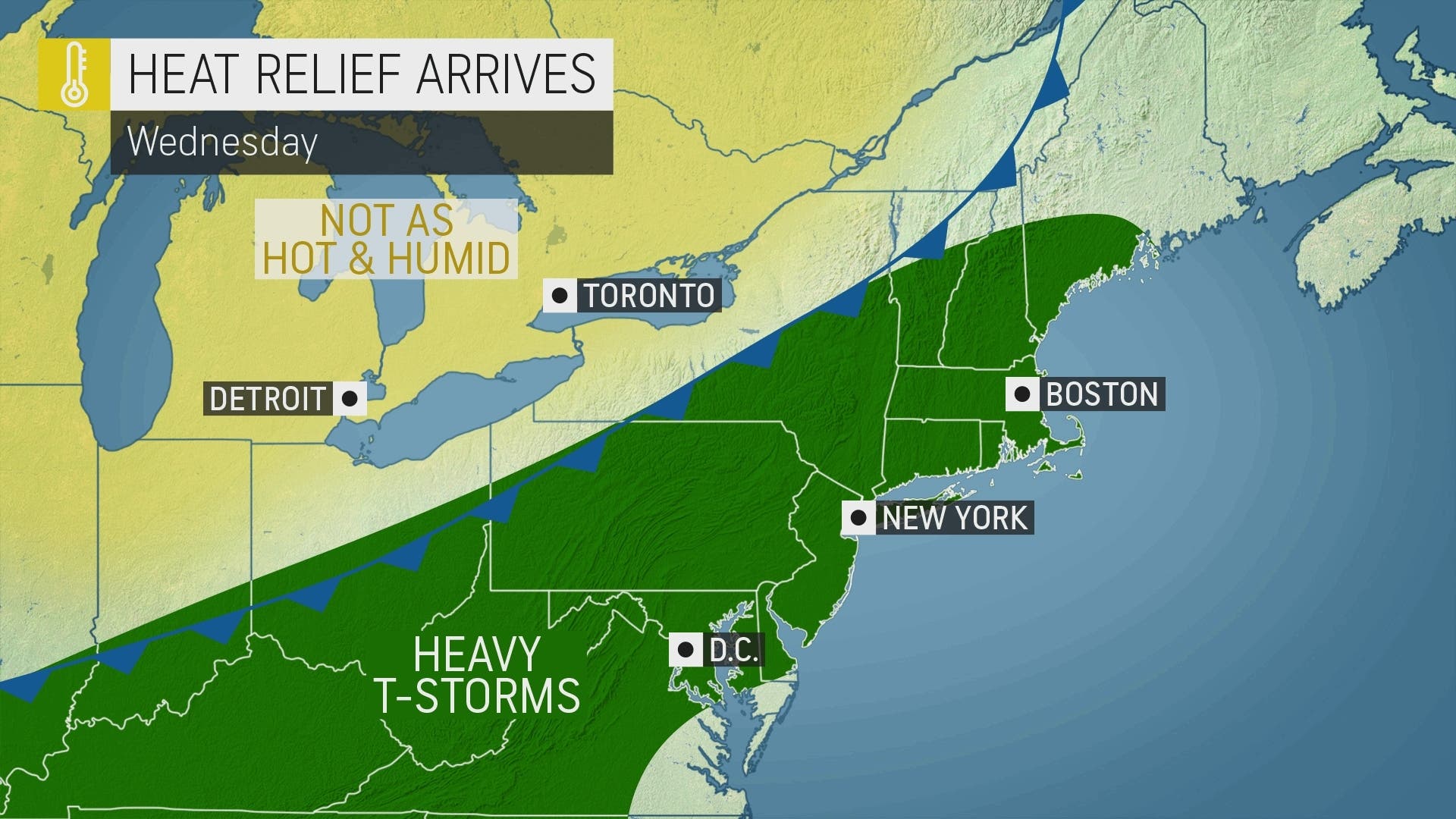
However, even in cities from Boston to New York City and Washington, D.C., temperatures will trend downward by several degrees by next weekend. Highs near 90 degrees Fahrenheit early in the week could be swapped with highs in the low 80s by Friday.
Here's the complete National Weather Service forecast for the DC/Northern Virginia area.
Monday: Isolated showers and thunderstorms after 2pm. Sunny, with a high near 95. Heat index values as high as 100. Southwest wind 6 to 9 mph. Chance of precipitation is 20%.
Monday Night: Isolated showers and thunderstorms before 11pm. Partly cloudy, with a low around 77. South wind around 6 mph becoming calm in the evening. Chance of precipitation is 20%.
Tuesday: A slight chance of showers, then a chance of showers and thunderstorms after 2pm. Sunny, with a high near 95. Heat index values as high as 105. Southwest wind 3 to 7 mph. Chance of precipitation is 30%.
Tuesday Night: A chance of showers and thunderstorms before 2am. Partly cloudy, with a low around 76. Southwest wind around 5 mph becoming calm in the evening. Chance of precipitation is 30%.
Wednesday: A slight chance of showers before 11am, then a slight chance of showers and thunderstorms between 11am and 2pm, then showers likely and possibly a thunderstorm after 2pm. Mostly sunny, with a high near 92. Calm wind becoming west around 5 mph in the afternoon. Chance of precipitation is 70%.
Wednesday Night: Showers likely and possibly a thunderstorm before 8pm, then a chance of showers and thunderstorms after 8pm. Mostly cloudy, with a low around 71. Chance of precipitation is 60%.
Thursday: Mostly sunny, with a high near 86.
Thursday Night: Partly cloudy, with a low around 68.
Friday: Sunny, with a high near 82.
Get more local news delivered straight to your inbox. Sign up for free Patch newsletters and alerts.