Weather
NoVa, DC Weather: Bomb Cyclone To Bring Snowy Dangerous Commute
NoVa drivers face a dangerous morning commute on Jan. 4, the National Weather Service warns, while Hampton Roads area faces a blizzard.

BALTIMORE, MD — As a winter hurricane forms in the Atlantic Ocean with a route that likely takes it along the coast, weather officials are urging northern Virginia and Washington, D.C., drivers to brace for a bitterly cold conditions and a dangerous Thursday morning commute under a winter weather advisory. The storm, which forecasters are calling a "bomb cyclone," is expected to dump more than 6 inches of snow across parts of New England Thursday. And the Norfolk-Virginia Beach region is under a blizzard warning with up to a foot of snow expected.
The increased potential for an inch or two of snow overnight in the Baltimore-Washington area has prompted the National Weather Service to issue a winter weather advisory to alert commuters. The advisory runs from 10 p.m. Wednesday to 11 a.m. Thursday. There is a 60 to 70 percent chance of snow Wednesday night through Thursday morning in the Baltimore-Washington metropolitan areas, with snow most likely near and east of Interstate 95, weather officials said.
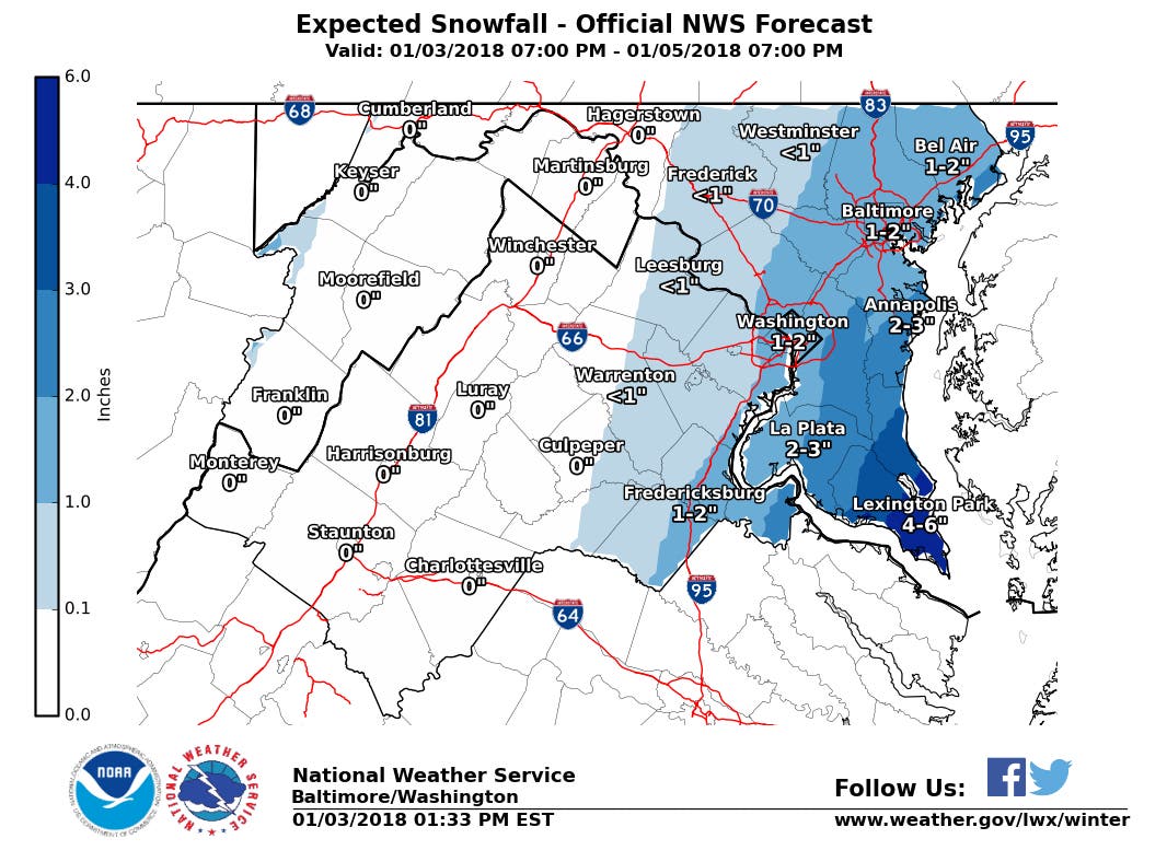
The forecast calls for an inch of snow to fall before 10 a.m. Thursday in the DC metro. The storm, which is being called a "bomb cyclone," may bring hurricane-force winds and polar vortex temperatures to the Eastern Seaboard. Expect 1 to 2 inches of snow from DC to Fredericksburg, while Leesburg and Warrenton could get less than an inch, the National Weather Service said Wednesday afternoon. (Sign up for Patch emails for more weather alerts; find your local Patch here. If you have an iPhone, click here to get the free Patch iPhone app.)
Find out what's happening in Arlingtonfor free with the latest updates from Patch.
"Very cold conditions mean that snow will quickly stick on roads and sidewalks making the Thursday morning commute dangerous. Plan ahead and allow extra time to get to your destination if traveling late Wednesday night or Thursday. Bitterly cold conditions will follow for late Thursday through the weekend, causing snow to remain on untreated surfaces," forecasters said.
A winter weather advisory for snow means periods of snow will cause primarily travel difficulties. Be prepared for snow covered roads and limited visibilities, and use caution while driving. The latest road conditions for the state you are calling from can be obtained by calling 5 1 1," weather officials advised for Thursday.
Find out what's happening in Arlingtonfor free with the latest updates from Patch.
Gov. Terry McAuliffe has issued a state of emergency authorizing state agencies to direct resources where they're needed, while VDOT has pre-treated roads and readied vehicles to plow snow. Along with Washington, D.C., areas in the weather advisory include: Prince William, Manassas, Manassas Park, Fairfax, Arlington, Falls Church, Alexandria, Stafford, Spotsylvania. Meanwhile a special weather statement on the hazardous commute applies to those communities plus Dale City, Woodbridge, Lake Ridge, Montclair, Reston, Herndon, Annandale, Centreville, Chantilly, McLean, Franconia, Falmouth, and Fredericksburg.
The track of the storm appears to be trending east. In the Tidewater area, the National Weather Service has issued a blizzard warning that goes into effect at 7 p.m. Wednesday and runs through 1 p.m. Thursday.
"Travel will be very dangerous to impossible, including during the morning commute on Thursday," warns the weather service. "Tree branches could fall as well. Total snow accumulations of 5 to 8 inches are expected with locally higher amounts up to 12 inches."
The blizzard warning includes Norfolk, Portsmouth, Chesapeake and Virginia Beach counties. Residents there should expect winds gusting as high as 50 mph to cause whiteout conditions in blowing snow. Significant drifting of the snow is likely.
The snow forecast from Wednesday to Thursday comes from an area of low pressure that is moving up the East Coast from Florida to the mid-Atlantic, producing rain in the southeast, snow in the mid-Atlantic and blizzard conditions as it reaches New England, according to the National Weather Service.
The fierce weather system meteorologists are calling a "bomb cyclone" has one airline warning travelers that flights to and from several cities could be cancelled or delayed Wednesday and Thursday as the storm makes its way up the eastern seaboard from Florida to Maine.
What's a bomb cyclone? The term is new to the winter weather vernacular, which includes others like "polar vortex" that scare the living daylights out of people. And if this storm develops to its full potential, a healthy fear is in order. At its worst, it could carry hurricane force winds, blinding snow and a bomb-like drop in pressure. And after the snow exits, the temperatures will dip into the polar vortex range with some of the coldest air of what has, at just three days old, already been a bone-chilling year.
As summer hurricanes do, the storm is expected to gather strength off the coast of Florida Wednesday, where it may bring snow and ice to areas not accustomed to such weather, then move on to the New England coast, where some areas could see up to 8 inches of snow.
See Also:
Graphics via National Weather Service
Get more local news delivered straight to your inbox. Sign up for free Patch newsletters and alerts.