Weather
Northern Virginia Weather: Florence Could Affect Work Week
Northern Virginia's work-week weather forecast has big changes in store, as well as the question of Hurricane Florence and its effects.


STERLING, VA—Folks in the Northern Virginia should expect a work week rife with more showers, omnipresent cloud cover, considerably higher temperatures and the slowly approaching Hurricane Florence. Of more immediate concern, the weekend's drenching rain has prompted the National Weather Service to issue a flood watch until 6 a.m. Monday.
Wednesday is expected to bring the best chances of sunshine, according to the NWS, but also should feature what the rest of the week will: a chance of thunderstorms amid highs in the mid to upper 80s. Lows are expected to dip only into the 70s.
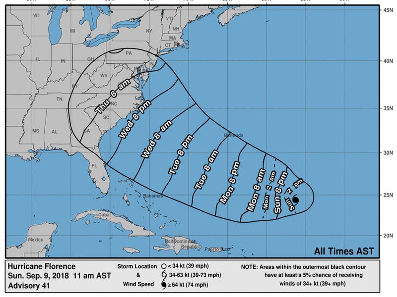
As for Hurricane Florence, which was upgraded Sunday from a tropical storm, Virginia Gov. Ralph Northam declared a state of emergency Saturday. That's primarily to mobilize resources ahead of the East Coast-bound storm, help mitigate any damage and streamline the process used to assist other states vulnerable to Florence, including the nearby Outer Banks of North Carolina.
Find out what's happening in Fredericksburgfor free with the latest updates from Patch.
It's not expected to reach land until Thursday. And then, as the Washington Post's Capital Weather Gang points out: "There is a real concern that the storm will slow or stall over the Mid-Atlantic on Friday through next weekend and produce disastrous amounts of rain, although it is too soon to pinpoint where."
Here's the detailed forecast from the National Weather Service:
Find out what's happening in Fredericksburgfor free with the latest updates from Patch.
Sunday Night: Rain. Low around 64. East wind 10 to 15 mph, with gusts as high as 23 mph. Chance of precipitation is 90%. New precipitation amounts between a half and three quarters of an inch possible.
Monday: Showers likely, with thunderstorms also possible after 9am. Mostly cloudy, with a high near 82. East wind around 8 mph becoming south in the afternoon. Chance of precipitation is 60%. New rainfall amounts between a quarter and half of an inch possible.
Monday Night: A chance of showers and thunderstorms. Mostly cloudy, with a low around 70. South wind 3 to 6 mph. Chance of precipitation is 50%.
Tuesday: A slight chance of showers, with thunderstorms also possible after noon. Mostly cloudy, with a high near 81. Northwest wind 5 to 7 mph. Chance of precipitation is 20%.
Tuesday Night: A slight chance of showers and thunderstorms. Mostly cloudy, with a low around 69. Chance of precipitation is 20%.
Wednesday: A chance of showers, with thunderstorms also possible after 8am. Partly sunny, with a high near 84. Chance of precipitation is 30%.
Wednesday Night: Mostly cloudy, with a low around 71.
Thursday: A chance of showers and thunderstorms. Mostly cloudy, with a high near 84. Chance of precipitation is 40%.
Thursday Night: A chance of showers. Mostly cloudy, with a low around 72. Chance of precipitation is 30%.
Friday: A chance of showers and thunderstorms. Mostly cloudy, with a high near 81. Chance of precipitation is 40%.
Friday Night: A chance of showers. Mostly cloudy, with a low around 70. Chance of precipitation is 30%.
Saturday: A chance of showers. Mostly cloudy, with a high near 79. Chance of precipitation is 30%.
Patch graphic/Image via National Hurricane Center
Patch editor Deb Belt contributed to this story
Get more local news delivered straight to your inbox. Sign up for free Patch newsletters and alerts.