Neighbor News
Heat continues - Severe Threat Friday
Heat Through Saturday. Severe Chance tomorrow. Better Sunday - Long term Heat Wave!
Short Term Weather
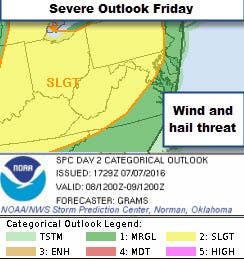
Needless to say the weather pattern flipped after Monday and we have been feeling it. Highs have been around 90 for the last 2 days and today was not different! I do not have to tell you how it feels! Hold on as we will see a bit of relief Sunday! Temps will remain hot tomorrow and a front will cross the region. With so much heat and humidity, strong to severe storms seem possible with the biggest threat from the storms being high winds and hail. There is also a chance for locally heavy rainfall in any storms. (For severe outlook information check the Severe Storm Prediction Center)
Temps in the low 70s tonight, around 92 tomorrow, and around 70 tomorrow night!
Find out what's happening in Leesburgfor free with the latest updates from Patch.
The Weekend - Looking better!
Temperatures will still be hot Saturday but the humidity will drop during the day. Sunday looks great with highs in the mid-80s! Night temp Saturday will be around 70 and the mid-60s for Sunday night
Find out what's happening in Leesburgfor free with the latest updates from Patch.
Longer Term
My feeling is that the rest of the summer we will tend to see above normal temperatures and trend towards drier conditions. We will see how that pans out, but the models are already hinting at a return to highs near 90 with high humidity by mid next week!
Words of Advice!
Typical summer cautions should be taken when outside! This means drinking a lot of water, taking frequent breaks from the sun if outside, not allowing pets in cars, and checking on your neighbors to make sure they are staying cool! Sunscreen is a must and ticks and mosquitos love this weather so do not forget the bug spray! More Heat Safety Tips on Patch.
Please Note:
These outlooks are not official forecasts and you should always refer to the National Weather Service for official forecasts, especially when it comes to protection of life and property. Data may not be current therefore the reader should always rely upon official forecast products for their area provided by the National Weather Service.