Neighbor News
Severe Possible - Mid week cool down, but the HEAT IS ON!
Heat will make itself known this week! A cooler Wednesday will fool you a bit as the hottest weekend yet is possible!
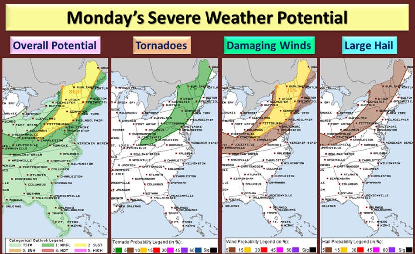
For today: (Above graphics from Storm Prediction Center Day 1 Outlook)
Summer heat will persist as we climb to the mid-90s today in the region! You have to stay hydrated and please take it easy! There is a chance of an afternoon storm. Although we have a chance of a heat breaking thunderstorm, the best chances for severe weather will be north of our area!
Tomorrow: We only have a slight chance of a storm, and some better humidity. High still in the upper 80s.
Find out what's happening in Leesburgfor free with the latest updates from Patch.
Wednesday: Best weather of the week! Highs may stretch to reach the mid-80s.
Thursday: The heat comes back! Temps again approach 90 and feel hotter!!
Find out what's happening in Leesburgfor free with the latest updates from Patch.
Friday: Even hotter mid-90s and looking dry!
The weekend looks to have temps in the mid and upper 90s possibly with a chance of showers and storms each day!
THERE IS A CHANCE that a brief cool down COULD show up in a little over a week. I think it will be brief! The hotter weather will continue to be the rule - possibly straight through the rest of the summer!Please note that this is very typical for a summer following a strong El Nino!
Here is a link to 7 Heat Safety Tips
Patch Weather Forecast for Leesburg, VA
Please Note:
These outlooks are not official forecasts and you should always refer to theNational Weather Service for official forecasts, especially when it comes to protection of life and property. Data may not be current therefore the reader should always rely upon official forecast products for their area provided by the National Weather Service.