Weather
State Of Emergency Declared In VA; Arctic Cold, 10+ Inches Of Snow Expected
VA residents should expect widespread closures with 10 inches of snow possible, plus wind chills of -10, the National Weather Service warns.

Updated at 3:20 p.m.
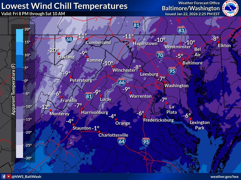
Very cold temperatures and arctic winds will combine to make it feel like 5 to 10 degrees below zero Friday night through Saturday morning as a winter snowstorm moves into Virginia. Forecasts on Thursday called for 5 to 10 inches of snow to blanket the DC region, as well as the polar air.
A cold weather advisory has been issued for part of the area with actual temperatures expected to drop into the single digits Friday night, the National Weather Service said.
Find out what's happening in Old Town Alexandriafor free with the latest updates from Patch.
Areas included in the cold weather advisory are the District of Columbia, Madison, Rappahannock, Culpeper, Fairfax, Arlington, Falls Church, Alexandria, Fauquier, Loudoun, Prince William, Manassas and Manassas Park.
The cold weather advisory will be in effect from 8 p.m. Friday to 10 a.m. Saturday.
Find out what's happening in Old Town Alexandriafor free with the latest updates from Patch.
Virginia Gov. Abigail Spanberger declared a state of emergency on Thursday ahead of this weekend's winter storm, which could dump more than 10 inches of snow and bring bitterly cold temperatures to the Washington, D.C. region.
The emergency declaration allows for state agencies and resources to be on standby across the Commonwealth. The storm is expected to move into the state Saturday night and continue through Monday afternoon.
"I am asking all Virginians to spend this time getting prepared for this incoming storm and to stay off the roads," Spanberger said. "This will allow not only for the safety and security of our neighbors, but for faster clearing of roads and ensure greater safety during what we expect will be the most dangerous times on the roads."
A winter storm watch is currently in effect for parts of Northern Virginia starting Saturday afternoon. Forecasters say they currently expect 5 inches of snow on the low end, but there is a possibility for some parts of the Baltimore-DC area could get 10 inches or more.
And sleet and freezing rain are likely to mix in with the heavy snow, creating hazardous driving condition. Dangerously cold wind chills and near record-breaking temperatures are expected Friday night through early next week.
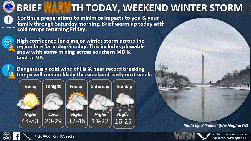
Forecasters with the National Weather Service for Baltimore/Washington, D.C. said in a Thursday morning briefing that winter storm watches have been issued for the entire area effective late Saturday afternoon through Sunday.
Heavy snow mixed with sleet and freezing rain is possible. There is a high likelihood of at least 5 inches of snow, with over 10 inches possible. Ice accumulation is also possible, the NWS said.
Here's what the agency said is coming to the DC region: "A large area of precipitation will overrun Arctic air in place over the Mid-Atlantic. This will likely lead to widespread significant snow beginning late Saturday, with the potential for ice Sunday, especially south of Highway 50 and near and east of Interstate 95.
"In addition to the high threat for significant snow and ice, very cold temperatures are expected Friday night through the middle of next week, with sub-zero wind chills likely at times."
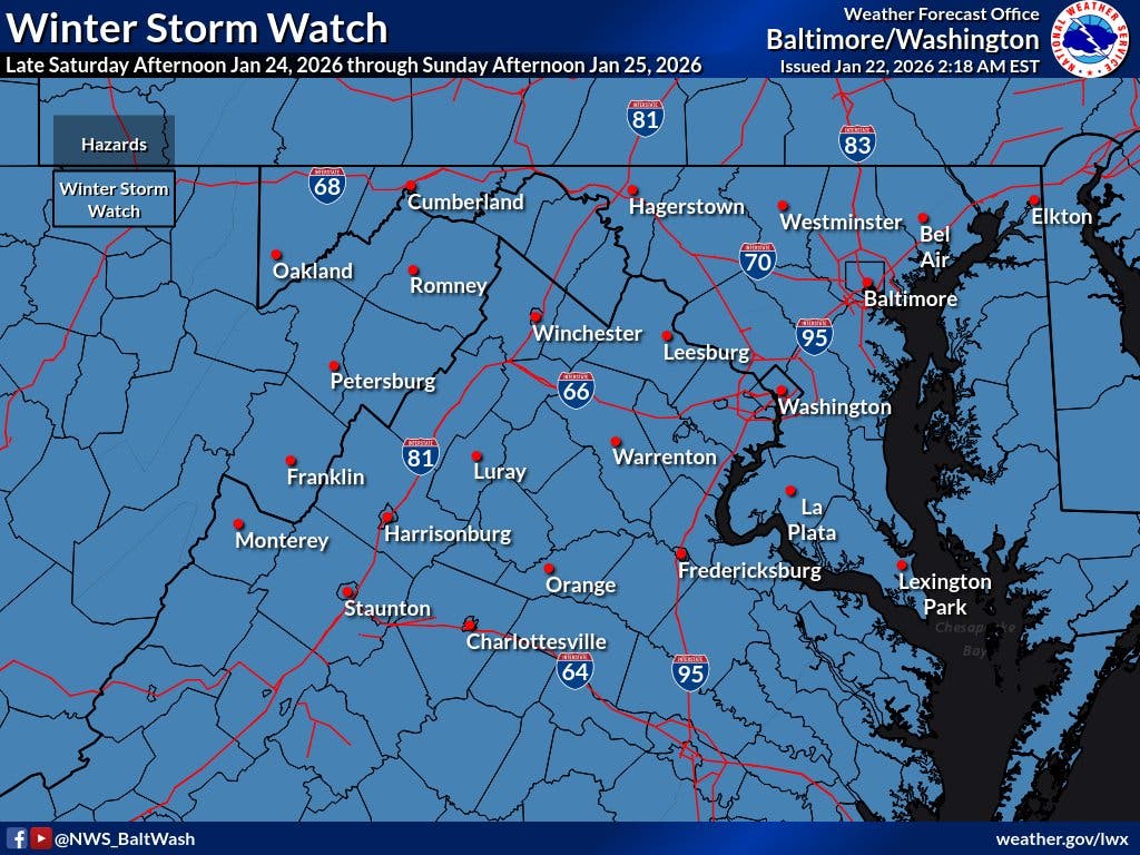
Areas included in the winter storm watch are: the District of Columbia, plus Fairfax, Arlington, Falls Church, Alexandria, Stafford, Spotsylvania, King George, Prince William, Manassas, and Manassas Park from Saturday evening through Monday morning.
Travel could be very difficult. The hazardous conditions could impact the Monday morning commute, forecasters said.
The storm will pass through the DC region between Saturday night and early Monday, with many schools likely to close next week, possibly for multiple days, according to The Washington Post's Capital Weather Gang.
"In the D.C. area, the main question is how much snow will fall and whether precipitation will change to an icy mix, coating the snow and trees and power lines with a hazardous glaze. Substantial snowfall of at least 4 to 8 inches is likely before any change to ice, most likely south and east of the Beltway," the Post said. "Areas that see all or mostly snow should receive at least 10 inches."
Snow will likely overspread the area Saturday evening, becoming heavy at times late Saturday night, with rates of one to two inches per hour possible at times, the NWS said. A mix with sleet or freezing rain is possible Sunday. Significant icing is possible, especially south of Highway 50. Visibility of one-quarter mile or less is possible at times. A prolonged period wind chills in the teens and single digits is likely beginning Friday evening and lasting through the middle of next week, with sub-zero wind chills possible at times.
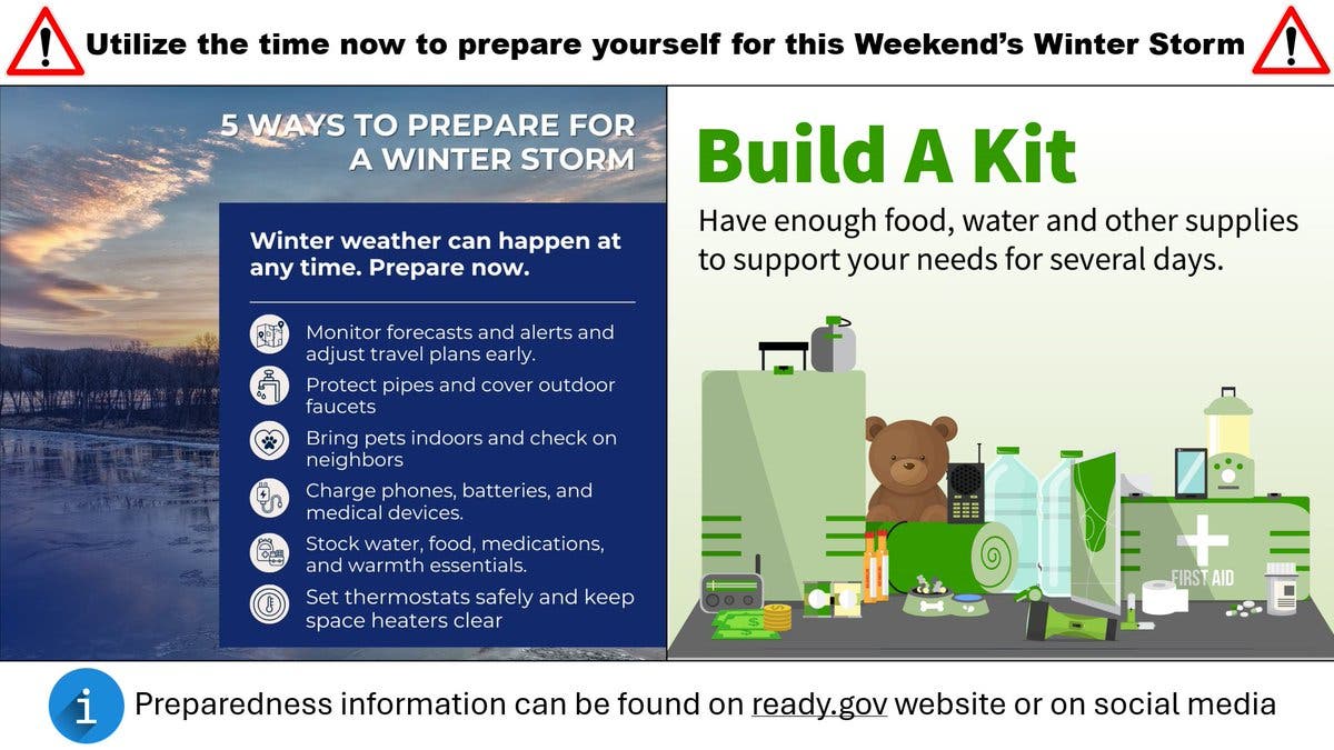
"Plowable snow & significant icing (especially south of I-66/US-50) can be expected," the NWS said. "The time is now to prepare to minimize impacts for you & your family."
You can find more at http://ready.gov.
Based on the European model centered on Baltimore, as of Wednesday, WBAL said there could be:
- A 95% chance of 3 inches or more snow accumulation
- An 85% chance of 6 inches or more
- A 45% chance of 12 inches or more
Get more local news delivered straight to your inbox. Sign up for free Patch newsletters and alerts.