Weather
Tropical Storm Ophelia: State Of Emergency Declared In VA
Ophelia has been classified as a tropical storm and is heading to the Mid-Atlantic, bringing a state of emergency in Virginia.


Updated at 3 p.m.
VIRGINIA — A state of emergency was issued in Virginia Friday as parts of the coast could see tropical storm force conditions this weekend due to Tropical Storm Ophelia, which one forecaster called a "formidable" tropical storm. Winds of up to 55 mph an hour are possible in the region, with flooding in the Washington, D.C., region likely, prompting a wind advisory to be issued.
Gov. Glenn Youngkin issued the state of emergency due to the tropical storm's potential impacts such as severe rainfall, flooding, wind damage and tornadoes. The governor said in a statement that the storm has been "difficult to accurately forecast" but could reach large population centers and at-risk communities.
Find out what's happening in Old Town Alexandriafor free with the latest updates from Patch.
In addition, Virginia State Police urged residents to stay off the roads as tropical storm conditions move into the state. Forecasts are calling for areas east of Interstate 95 to be affected the most by heavy rains and strong winds that could top 50 mph.
Virginia State Police have all available troopers and supervisors working through the weekend as the storm makes it through the Fredericksburg and Northern Virginia regions. "To prevent unnecessary traffic crashes from occurring on Virginia’s highways, state police advises residents to postpone travel plans and avoid driving, if possible," the agency said.
Find out what's happening in Old Town Alexandriafor free with the latest updates from Patch.
Related: VA Residents Urged To Prepare For 'Nasty' Tropical Storm Ophelia
The state of emergency will allow Virginia agencies to be ready with resources if needed, the governor said. The Virginia Emergency Support Team will be activated.
"We want to ensure that all communities, particularly those with the greatest anticipated impact, have the resources they need to respond and recover from the effects of this storm," said Youngkin in a statement. "Since this storm has the potential to have a range of impacts across numerous localities in the commonwealth, I encourage all Virginians and visitors to keep up with the latest forecast for their area from a trusted source, make a plan, and have their emergency kits ready."
Parts of Northern Virginia and DC are under a coastal flood watch Saturday morning to night, including shorelines in Arlington and Alexandria. The flooding risk will be especially present during high tides. For example, forecasters expect tidal flooding along parts of the seawall near Ohio Drive, the Hains Point Loop Road and the Tidal Basin in DC, as well as King Street and Strand in Alexandria.
A wind advisory will be in effect from 8 a.m. to 8 p.m. Saturday for portions of central, northeast and southern Maryland, the District of Columbia and central and northern Virginia. Northeast winds of 20 to 30 mph with gusts up to 45 mph are expected in the DC-Baltimore region. Gusts up to 50 mph are likely along the immediate shore of the Chesapeake Bay and tidal Potomac.
The wind advisory includes: the District of Columbia, Fairfax, Arlington, Falls Church, Alexandria, Stafford, Spotsylvania, King George, Fauquier, Loudoun and Prince William counties.
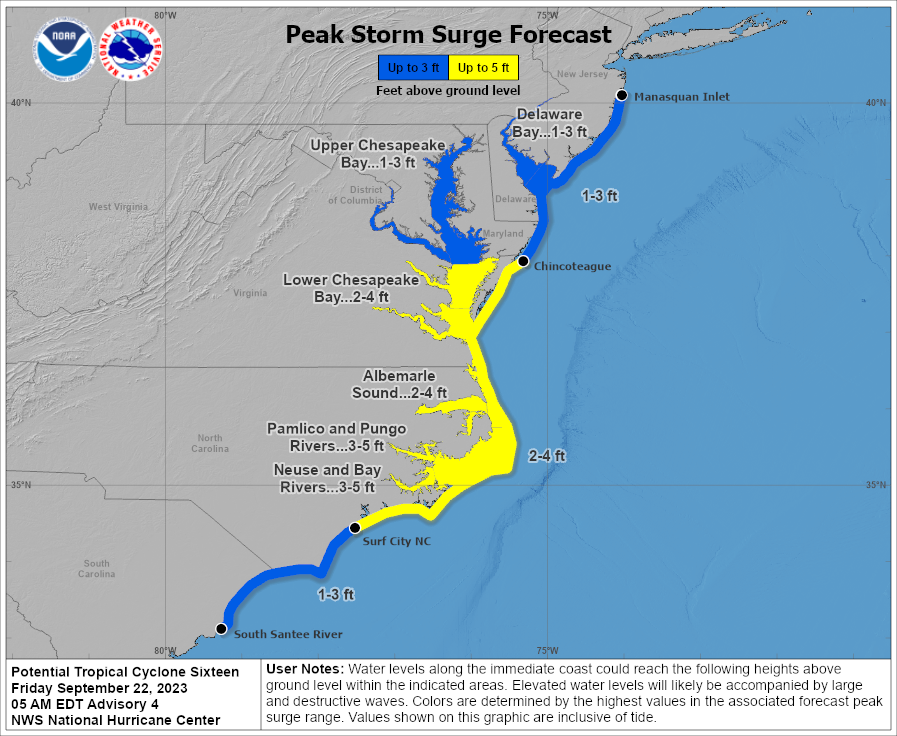
The tropical storm could go inland in eastern North Carolina early Saturday and reach parts of the Mid-Atlantic Saturday and Sunday. According to the National Hurricane Center, the storm brings threats of life-threatening storm surge, tropical-force winds, heavy rain and flooding.
Areas away from the coast like Northern Virginia could see localized flooding from heavy rain. Forecasters expect swells from the storm to likely cause life-threatening surf and rip currents on the Mid-Atlantic coast through Sunday.
The National Hurricane Center said Friday, "based on recent trends, it seems likely that the low will become a subtropical or tropical cyclone" later Friday.
"Confidence is high that the system brewing just off the Atlantic coast will become a tropical or subtropical storm," said Dan Pydynowski, an AccuWeather senior meteorologist. "A subtropical storm, which has both tropical and non-tropical characteristics associated with it, is most likely due to the structure of the storm."
The Weather Channel expects the storm system's peak to happen on Friday and Saturday, with few impacts remaining possible Sunday.
Some coastal areas in southeastern Virginia have potential for life-threatening storm surge, according to the National Weather Service in Wakefield. Forecasters say residents in the affected areas should make flood preparations and prepare to evacuate if orders are given.
"People in coastal areas should take this storm seriously," added AccuWeather's chief on-air meteorologist Bernie Rayno. "This is going to be a nasty and formidable storm."
According to the National Weather Service, the probability of tropical storm-force winds is highest along parts of the North Carolina coast — about 80 to 90 percent. Virginia's coast has between 30 to 60 percent chance of tropical storm-force winds, while Northern Virginia has about a 10 to 20 percent probability. Wind impacts will arrive late Friday to early Saturday in southeastern Virginia, while Northern Virginia will see impacts sometime after 8 a.m. Saturday and before Saturday night.
The tropical storm warning remains in effect through Sunday morning, covering coastal areas from Fenwick Island in Delaware to Currituck Beach Light in North Carolina, including the Chesapeake Bay from Smith Point to Cape Henry.
In the greater DC region, a tropical storm warning is affecting areas of southern Maryland, including Calvert and St. Mary`s Counties. Low-lying coastal areas will be especially vulnerable to moderate to major coastal flooding, according to the National Weather Service's Baltimore-Washington office.
Another flooding threat will come from heavy rain, affecting places like rivers, streams, low-lying areas and poor drainage spots. Some coastal areas could see tropical storm force winds as high as 30 to 40 mph, with gusts to 55 mph. Winds could blow lightweight objects, cause large tree limbs to fall, uproot some trees, damage roadway signs, make some roads impassible and cause scattered power outages. In addition, winds could cause hazardous waves that could capsize or damage boats.
Here's a look at the forecast for the DC region through the weekend:
Friday: Mostly cloudy, with a high near 75. Rain, mainly after 11 p.m. and low around 58.
Saturday: Rain. High near 64. Breezy, with a north wind 23 to 25 mph, with gusts as high as 40 mph. At night, rain before 2 a.m., then showers and low around 59. Breezy, with a north wind 16 to 25 mph, with gusts as high as 38 mph.
Sunday: Showers, mainly before 8 a.m. and high near 67. At night, mostly cloudy, with a low around 59.
Get more local news delivered straight to your inbox. Sign up for free Patch newsletters and alerts.