Weather
Tornado Watch Issued In NoVA
A storm system that spawned damaging tornadoes and record-sized hail across the Midwest on Tuesday moves into Virginia Wednesday afternoon.

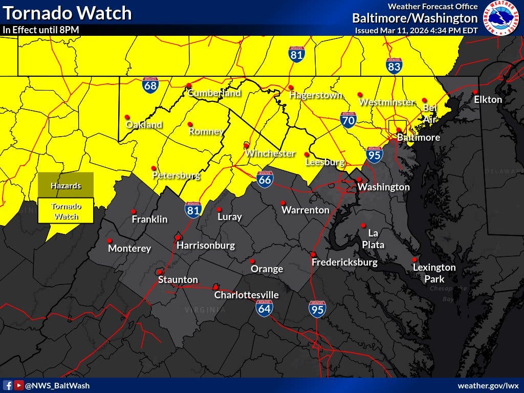
Forecasters on Wednesday afternoon issued a tornado watch for a portion of Northern Virginia as a powerful cold front moves into the state, bringing the possibility of severe thunderstorms, large hail and damaging winds to the D.C. region.
Around 4:20 p.m., the National Weather Service expanded a tornado watch to include Loudoun County. The alert is in effect until 8 p.m.
An earlier tornado watch remains in effect for the city of Winchester and Clarke, Frederick, Shenandoah and Warren counties in Northwest Virginia. A hazardous weather outlook remains is also still in effect for the remainder of Northern Virginia.
Find out what's happening in Old Town Alexandriafor free with the latest updates from Patch.
Wednesday is forecast to start unseasonably warm with afternoon highs in the upper 70s to mid-80s, before a storm system that spawned damaging tornadoes and record-sized hail across the Midwest on Tuesday moves into the state this afternoon.
According to the National Weather Service, the greatest likelihood for severe weather will be between 4 and 9 p.m. as the incoming cold front pushes across the state.
Find out what's happening in Old Town Alexandriafor free with the latest updates from Patch.
On Wednesday, Northern Virginia remained at a level 2 out of 5 risk for severe weather, according to the NWS Storm Prediction Center.
The National Weather Service said Wednesday's storm system may be capable of producing strong thunderstorms, damaging wind gusts of 60 to 70 mph, a few instances of large hail, and a few tornadoes, which could be strong.
"Pay close attention to warnings, should they be issued, and have multiple ways to receive them," the National Weather Service's Baltimore-Washington office wrote on X.
In their latest forecast, The Washington Post's Capital Weather Gang said storms will likely be more numerous across northern Maryland and into the Potomac Highlands.
"Most short-term models don’t show much in the way of storm development in the Capital Beltway area. And those that show storms suggest they’ll be widely scattered," the Capital Weather Gang wrote. "Showers and perhaps some downpours are much more likely in the immediate D.C. area toward Thursday morning but are unlikely to be severe."
On Thursday, rain showers are likely during the morning and could linger into early afternoon, possibly mixing in with a snowflake or two.
This will be followed by a series of cold fronts crossing the area into early next week, leading to multiple temperature swings.
Temperatures are expected to take a 15- to 30-degree dive on Thursday before warming again this weekend. The Baltimore region should see temperatures in the mid- to upper 50s on Saturday and then 50s to low 60s on Sunday.
Temperatures will fall again early next week, ushering in a return to more winter-like conditions.
Here's a look at the detailed National Weather Service forecast for the D.C. region:
Wednesday: A chance of showers and thunderstorms before 2pm, then a chance of showers and thunderstorms after 3pm. Partly sunny, with a high near 80. South wind 9 to 11 mph, with gusts as high as 23 mph. Chance of precipitation is 30%.
Wednesday Night: A chance of showers and thunderstorms, then showers after 2am. Some of the storms could be severe. Low around 47. South wind 10 to 15 mph, with gusts as high as 18 mph. Chance of precipitation is 80%. New precipitation amounts of less than a tenth of an inch, except higher amounts possible in thunderstorms.
Thursday: Showers, mainly before 8am. Temperature falling to around 47 by noon. Breezy, with a northwest wind 18 to 23 mph, with gusts as high as 34 mph. Chance of precipitation is 80%. New precipitation amounts between a tenth and quarter of an inch possible.
Thursday Night: Mostly clear, with a low around 35. Northwest wind 8 to 13 mph becoming light west after midnight.
Friday: Partly sunny, with a high near 57. Breezy, with a south wind 9 to 14 mph increasing to 19 to 24 mph in the afternoon. Winds could gust as high as 39 mph.
Friday Night: Partly cloudy, with a low around 43.
Saturday: Mostly sunny, with a high near 57.
Saturday Night: Mostly cloudy, with a low around 42.
Sunday: Mostly cloudy, with a high near 60.
Sunday Night: Rain, mainly after 8pm. Low around 52. Breezy. Chance of precipitation is 80%.
Monday: Rain. High near 62. Windy. Chance of precipitation is 80%.
Get more local news delivered straight to your inbox. Sign up for free Patch newsletters and alerts.