Crime & Safety
CA Wildfires Latest: Red Flag Conditions And 15 Major Fires
Red flag wind conditions in the north hamper firefighting efforts, while lightning storms in the south threaten to ignite new blazes.

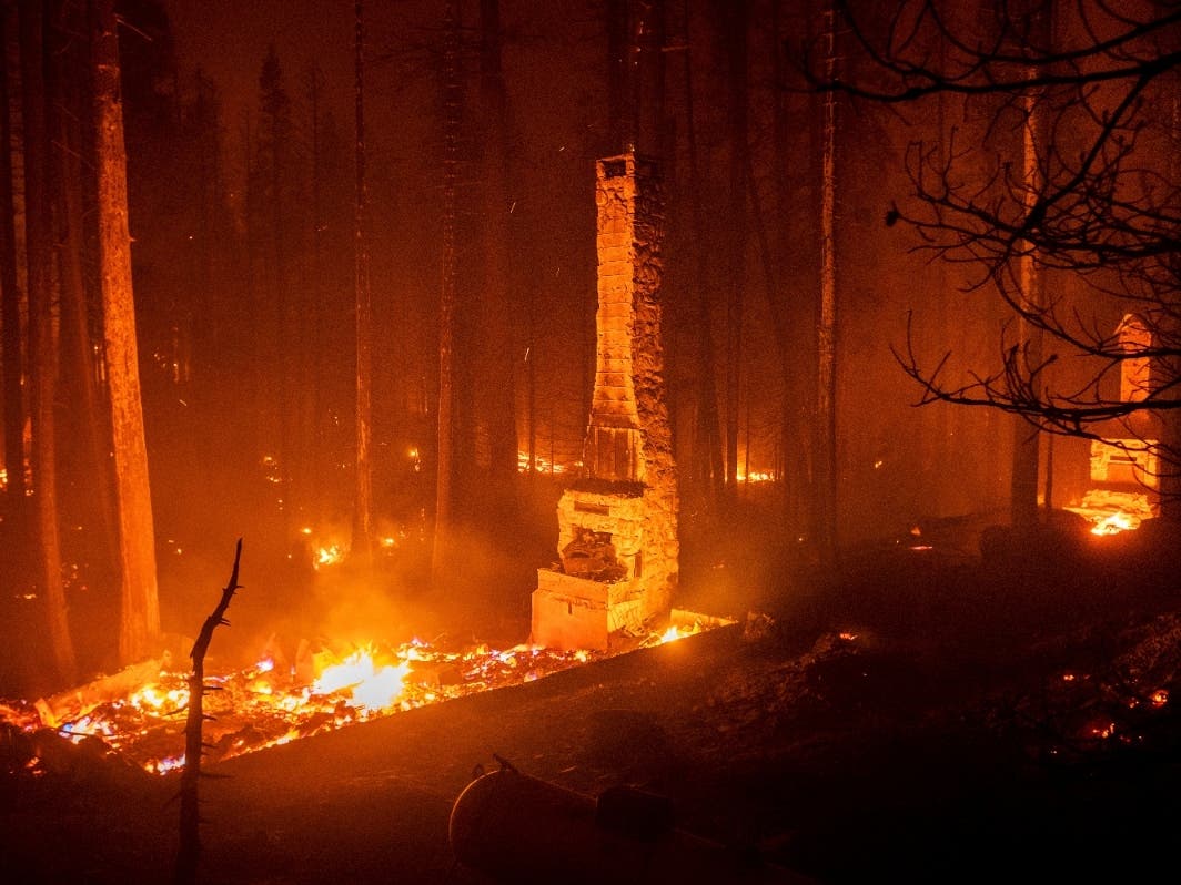
CALIFORNIA — More than 15,000 firefighters battled 15 major wildfires Monday amid red flag wind conditions in Northern California, where the Caldor fire continued to menace the Lake Tahoe region.
Farther south, firefighters are contending with the threat of lightning storms for the next two days in Southern California, where a brush fire ignited in the San Bernardino National Forest on Sunday.
Firefighting forces in California are battling monster blazes that have been burning for weeks as dozens of new ones break out each day, including 31 new wildfires sparked on Sunday, Cal Fire reported.
Find out what's happening in Los Angelesfor free with the latest updates from Patch.
Residents were forced on Monday morning to flee from a long section of the Lake Tahoe shoreline as the 177,260-acre Caldor fire threatened the resort region.
The speed at which the massive fire barreled down caught many off guard.
Find out what's happening in Los Angelesfor free with the latest updates from Patch.
South Lake Tahoe Mayor Tamara Wallace was among those leaving ahead of an evacuation order. She and her husband took their dogs and items given to them from deceased parents — objects that can't be replaced.
Wallace did not think the Caldor fire would come so close. Fires in the past did not spread so rapidly near the resort city of 22,000 people.
“It's just yet another example of how wildfires have changed over the years,” she said. “It's just a culmination of 14 to 18 more years of dead trees, the droughts we’ve had since then, those kinds of things.”
Firefighters on Monday braced for heavy wind gusts to continue driving the wildfire.
A red flag warning for critical fire weather is in effect from 11 a.m. Monday through 11 p.m. Tuesday, covering Modoc County, the northern Sierra Nevada, the Tahoe Basin and Mono County, for gusty winds and low humidity, Cal Fire reported Monday.
Hot and dry conditions will remain throughout Northern California Monday, with thunderstorms moving across Southern California east and south of Los Angeles County through Wednesday, the agency added. Most of the storm activity is expected to occur over the mountains and higher desert areas in the afternoons.
Since the beginning of the year, wildfires have burned more than 1.76 million acres in California, and fire officials expected conditions to become even more dire as the fire season heats up going into the fall.
To help Californians keep safe and keep tabs on where fires are burning, the National Alliance for Public Safety GIS Foundation created an interactive map showing all active fires.
The map showed recently contained fires and regions that have a red flag warning in place. The map does not show evacuation routes, but the foundation also maintains a spreadsheet with updated evacuation maps in areas that apply.
Cal Fire Currently Monitors 13 Fires Of Interest
Caldor Fire: El Dorado County, South Of Grizzly Flats – El Dorado National Forest
- 177,260 acres, 14 percent contained.
- Nearly 20,000 structures threatened.
- 653 structures destroyed.
- Evacuation orders and warnings remain in place, new evacuation orders issued.
Chaparral Fire: Riverside And San Diego Counties — Southwest Of Murrieta – Cleveland National Forest
- 1,427 acres, 13 percent contained.
- Evacuation orders and warnings in place.
- Unified Command Cal Fire and the U.S. Forest Service.
Dixie Fire: Butte, Plumas, Lassen, Tehama And Shasta Counties
- 771,183 acres, 48 percent contained.
- Nearly 11,500 structures threatened.
- More than 1,208 structures destroyed (14th most destructive wildfire).
- Evacuation orders and warnings in place for multiple communities.
- Unified Command of Cal Fire, U.S. Forest Service, Bureau of Land Management and National Park Service.
French Fire, Kern County, Sequoia National Forest
- 25,264 acres, 26 percent contained.
- Evacuation orders in place.
Monument Fire: Trinity County, Five Miles West Of Big Bar, Shasta-Trinity National Forest
- 164,746 acres, 29 percent contained.
Federal Incidents
Antelope Fire: Siskiyou County, Five Miles South Of Tennant, Klamath National Forest
- 71,447 acres, 51 percent contained.
Knob Fire: Humboldt County, Two Miles South Of Willow Creek, Six Rivers National Forest
- 250 acres, 0 percent contained.
- Evacuations in progress.
McFarland Fire: Shasta, Trinity And Tehama Counties, Shasta-Trinity National Forest
- 122,653 acres, 94 percent contained.
River Complex: Siskiyou County, Seven Miles West Of Callahan, Klamath National Forest
- 98,832 acres, 23 percent contained.
- Complex comprised 23 fires; 16 fires contained
- Evacuation orders in place.
McCash Fire: Siskiyou County, Ten Bear Mountain McCash Creek, Six Rivers National Forest
- 33,242 acres, 1 percent contained.
Walkers Fire: Tulare County, 16 Miles Northeast Of Springville, Sequoia National Forest
- 7,638 acres, 45 percent contained.
Lava Fire: Siskiyou County, Northeast Of Weed, Shasta-Trinity National Forest
- 26,409 acres, 90 percent contained.
- Two structures damaged.
- 23 structures destroyed.
Beckwourth Complex: Lassen/Plumas Counties, Northeast Of Beckwourth, Plumas National Forest
- 105,670 acres, 98 percent contained.
- 23 structures damaged.
- 148 structures destroyed.
South Fire: San Bernardino County, North Of Fontana – San Bernardino National Forest
- 819 acres, 49 percent contained.
- Evacuation orders and warnings remain in place.
Tamarack Fire: Alpine County, South Of Gardnerville, Humboldt-Toiyabe National Forest
- 68,637 acres, 82 percent contained.
Extended Attack Incident
Railroad Fire: San Bernardino County, Off Interstate 15 In The Cajon Pass – San Bernardino National Forest
- 25 acres, 30 percent contained.
Roadside Fire: San Bernardino County, Cajon Pass – San Bernardino National Forest
- 50 acres, 30 percent contained.
Washington Fire, Tuolumne County, West Of Sonora
- 100 acres, 50 percent contained.
Historic drought and recent heat waves tied to climate change have made wildfires more difficult to quell on the West Coast. Rising temperatures have made the American West much warmer and drier in the past 30 years and will continue to make weather more extreme and wildfires more frequent and destructive, scientists have said.
The explosive pace of new wildfires showed no sign of slowing.
The Dixie fire is the Golden State's largest wildfire so far this year, burning 771,183 acres and destroying more than 1,200 structures and more than 600 homes.
Pacific Gas & Electric Co. equipment may have ignited the Dixie fire, according to a report released by the utility last month.
Last month, a repairman reportedly spotted what he suspected to be a blown fuse while he was responding to an outage in Feather River Canyon off state Route 70 in Oroville. Because of rough terrain and roadwork, the worker could not reach the pole for several hours, the utility said. By the time he reached the area, two or three blown fuses may have sparked a fire at the base of a healthy green tree leaning on the pole that held the conductor.
The combination of worsening drought, rising temperatures and arid fuels pointed to another devastating wildfire season, Gov. Gavin Newsom warned in May.
"You're already feeling the temperature shifts," he told reporters. "You already saw those red flag warnings, which are earlier in May than we've seen in many, many years because of the winds that are coming earlier. "
READ MORE:
- 4 Key Things To Know About CA's 2021 Wildfire Season
- PG&E Says Its Equipment May Have Sparked NorCal Fire
Patch Editor Kat Schuster and the Associated Press contributed to this report.
Get more local news delivered straight to your inbox. Sign up for free Patch newsletters and alerts.