Weather
'Bomb Cyclone': Rain Totals In Each Bay Area City
An atmospheric river storm deluged NorCal over the weekend, flooding roads, toppling trees, cutting power and shattering rainfall records.

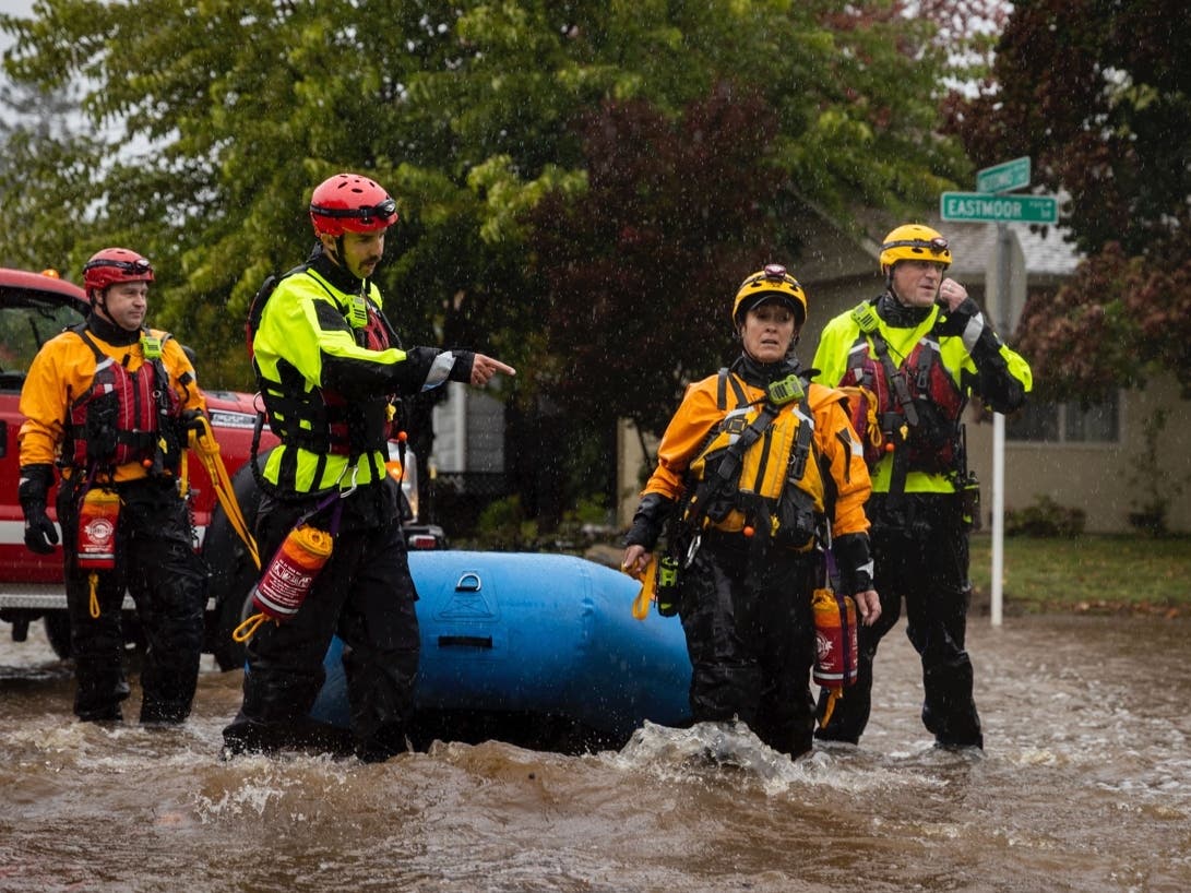
SAN FRANCISCO, CA — Torrential downpours came with the weekend arrival of an atmospheric river storm system to the Bay Area, shattering rainfall records in drought-stricken California. Also dubbed a "bomb cyclone," the massive storm toppled trees, flooded busy highways and homes, prompted evacuations and cut power to about 380,000 people.
Atmospheric rivers are "relatively long, narrow regions in the atmosphere — like rivers in the sky," according to the National Oceanic and Atmospheric Administration. A bomb cyclone occurs when a storm undergoes bombogenesis, meaning it rapidly intensifies over a 24-hour period, according to NOAA.
Weather officials warned ahead of the storm that the region could be in for "potentially historic rain," and Sunday's finale of the massive storm more than delivered on that warning.
Find out what's happening in San Franciscofor free with the latest updates from Patch.
In just 48 hours, Mount Tamalpais recorded 16.55 inches — the highest rain total of any area this weekend. In downtown San Francisco, 4.02 inches of rain fell on Sunday — the wettest October day ever, according to the National Weather Service.
The National Weather Service issued several flash flood warnings on Sunday as first responders worked furiously to mitigate mudslides, fallen power poles and debris flows and to facilitate evacuations in some regions.
Find out what's happening in San Franciscofor free with the latest updates from Patch.
READ MORE: 14 Images Of California's Powerful Storm: Flooding, Debris And More
Tallying our climate numbers. Looks like 4.02 inches of rain for the calendar day in downtown SF. By far the wettest Oct day ever (old record 2.48 inches 10/13/09). 4th Wettest day EVER in SF with records back to Gold Rush. #AtmosphericRiver pic.twitter.com/JwlmhviJOC
— NWS Bay Area (@NWSBayArea) October 25, 2021
The weather service called preliminary rainfall totals "staggering."
Sunday was the fourth-wettest day ever for downtown San Francisco in records that went back to the Gold Rush years, the weather service said.
In the state's Central Valley, Sacramento got 5.4 inches of rain, shattering the all-time one-day rainfall record dating to 1880, the weather service said.
See a full list of rain totals in each Bay Area city here.
Flooding was reported across the San Francisco Bay Area, closing streets in Berkeley, inundating Oakland's Bay Bridge toll plaza and overflowing rivers in Napa and Sonoma counties.
Several homes were flooded in Santa Rosa on Sunday, and authorities urged residents not to attempt to drive through flooded streets in the city.
Some Of The Highest Rain Totals For Bay Area Cities
- Mount Tamalpais: 16.55 inches.
- Venando: 14.26 inches.
- Woodacre Raws: 13.14 inches.
- Danville: 10.15 inches.
- Boulder Creek: 10.13 inches.
- Barnaby Raws: 10.08 inches.
- Oakland: 9.04 inches.
- Saint Helena: 8.79 inches.
- Novato: 8.47 inches.
- San Francisco: 7.95 inches.
- Spring Valley: 8.62 inches.
- Lake Elsman: 7.7 inches.
- San Rafael: 6.47 inches.
- South San Francisco: 5.09 inches.
- Napa: 5.5 inches.
“It's been a memorable past 24 hours for the Bay Area as the long-talked-about atmospheric river rolled through the region,” a Bay Area weather service office said. "We literally have gone from fire/drought conditions to flooding in one storm cycle."
The extreme atmospheric river system was forecast to effectively end another destructive wildfire season and quell some drought concerns in Northern California. But on Sunday it brought a slew of other dangers, such as flooding and mudslide risks in fire-scarred California.
By Sunday morning, Mount Tamalpais just north of San Francisco had recorded a half-foot of rainfall during the previous 12 hours, according to the weather service.
"Some of our higher elevation locations could see 6, 7, 8 inches of rain before we're all said and done," weather service meteorologist Sean Miller told The Associated Press.
Flash flood warnings were issued to several areas of Northern California, where fire-scarred land posed a significant risk of debris flows.
Debris flows tend to manifest during massive rainfall events, transforming the ground into a treacherous river of mud. These mud rivers can flow rapidly, striking with little or no warning at avalanche speeds — faster than a person can run — according to Ready.gov, a website created by the U.S. government to help citizens cope with emergencies.
About 150 miles to the north, the California Highway Patrol closed a stretch of State Route 70 in Butte and Plumas counties because of multiple landslides within the massive Dixie fire burn scar.
"We have already had several collisions this morning for vehicles hydroplaning, numerous trees falling, and several roadways that are experiencing flooding," the highway patrol's office in Oroville tweeted on Sunday. "If you can stay home and off the roads today, please do. If you are out on the roads, please use extreme caution."
Don't go chasing the waterfalls at Waddell Beach in Santa Cruz County on Highway 1, about 1/2 mile south of the San Mateo County line. #CaWx #California pic.twitter.com/v94Q6pMBGo
— CAL FIRE CZU (@CALFIRECZU) October 25, 2021
The extreme weather also toppled trees and tipped power poles, sending sparking wires into the roads.
Some 66,000 residents had lost power by 1 p.m. Sunday, according to Pacific Gas & Electric Co. The utility warned ahead of the storm that it would likely bring torrential rain, heavy mountain snow and intense winds that could cause widespread outages.
As the storm barreled through the Bay Area Sunday, PG&E also warned residents not to touch or get anywhere near downed wires. Downed wires can be reported by calling 911 or PG&E directly at 800-743-5002.
"Never touch downed wires: If you see one, assume it is energized and extremely dangerous," PG&E tweeted on Sunday. "Do not touch or try to move it — keep children and animals away."
The same storm system also slammed Oregon and Washington state, causing power outages that affected tens of thousands of people. Two people were killed when a tree fell on a vehicle in the greater Seattle area.
Mountain areas above 9,000 feet in the Sierra Nevada could get 18 inches or more of snow from Sunday until Monday morning, officials said.
Recent storms helped quell some of the nation’s largest wildfires this year. But it remains to be seen if the wet weather will make a dent in the drought that’s plaguing California.
California’s 2021 water year, which ended Sept. 30, was the second-driest on record, and last year’s was the fifth-driest on record.
The Associated Press contributed to this report.
Get more local news delivered straight to your inbox. Sign up for free Patch newsletters and alerts.