Weather
Bomb-Cyclone To Unleash Flooding, Mudslides And Snow Storms Across CA
Gov. Gavin Newsom declared a state of emergency as a massive storm unleashes flooding, power outages and mudslides.


CALIFORNIA — Flooded roads, sandbagged homes, power outages and concern about loss of life grips California as an atmospheric river began dropping several inches of rain on the state’s most populated areas. Multiple cities and towns declared states of emergency, while transit systems canceled ferry service, and train schedules have been disrupted.
Governor Gavin Newsom proclaimed a state of emergency throughout California Wednesday morning to support the ongoing storm response. The state has prepositioned resources, both equipment and personnel including swift water rescue teams, especially near burn scars.
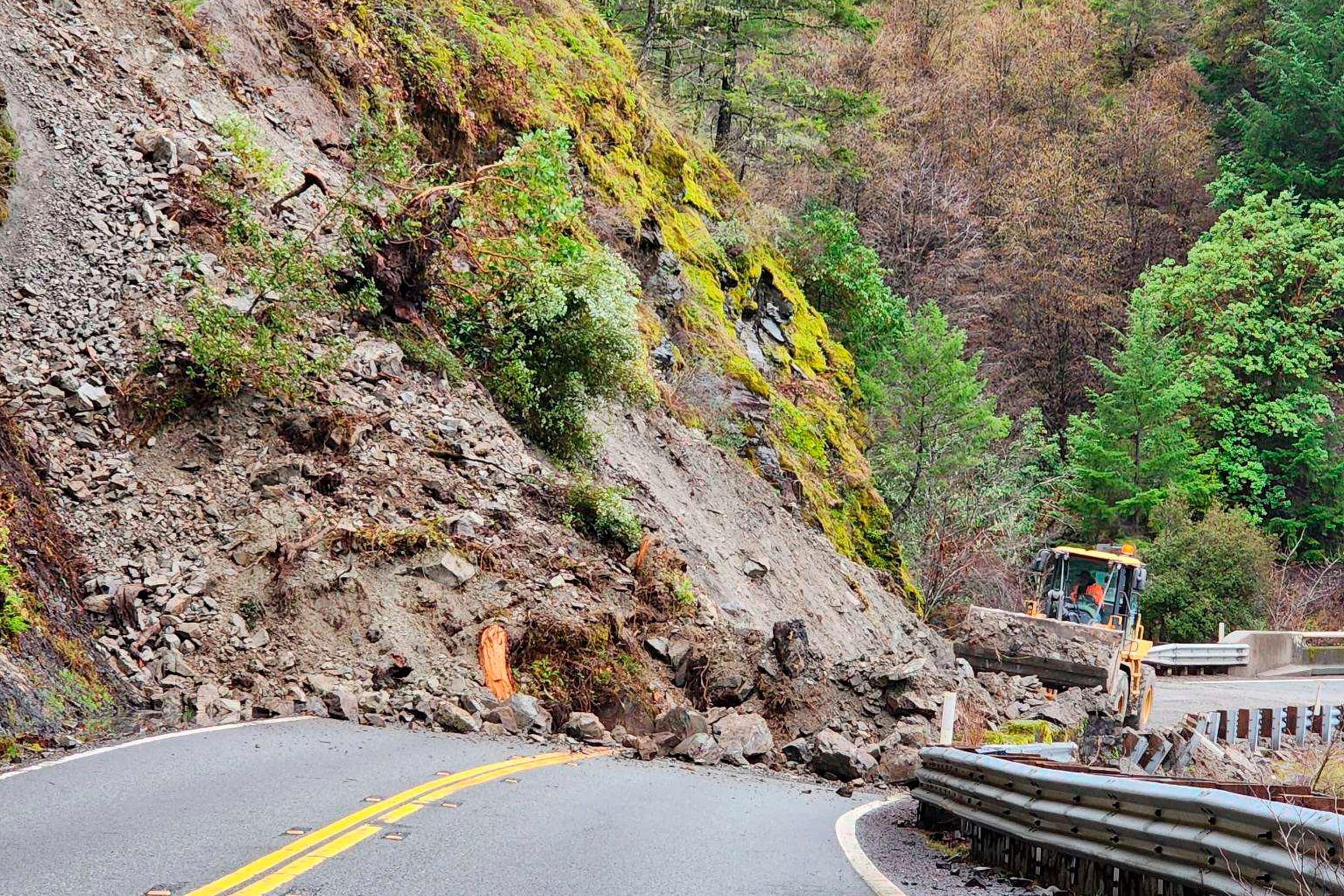
According to AccuWeather, the cities of San Francisco, Sacramento and Los Angeles will receive enough rain from the storm to cause flash flooding. Caltrans officials are warning drivers to stay off the roads, if possible, as pounding rain and wind are expected to trigger mud and rock slides and high surf.
Find out what's happening in San Franciscofor free with the latest updates from Patch.
The rain is falling on soil that is already saturated from weekend storms that unleashed flooding.
"There will be many potential problems associated with this storm system including urban and small stream flooding, rocks and debris on roads, downed trees and numerous power outages, and mud and debris flows out of recent burn areas," warned the National Weather Service.
Find out what's happening in San Franciscofor free with the latest updates from Patch.
SEE ALSO: Bomb Cyclone, Foods Expose CA Vulnerabilities
AccuWeather officials also stressed the dangers associated with the storm.
"There is a significant risk for flash flooding, and people should watch for and avoid rapidly rising water which can quickly become life-threatening," AccuWeather Chief Meteorologist Jon Porter said. “This will be a dangerous and high-impact storm for California, capable of producing life-threatening conditions and significant disruption which may last several days.”
The PG&E outage map shows that thousands of customers have lost power in Sonoma, Alameda, Santa Clara and Sacramento counties. Crews are restoring electricity as fast as possible but as soon as one is cleared, another crops up. In Southern California, the Southern California Edison outage map showed about 1,700 power outages. San Diego Gas & Electric was not immediately reporting outages.
ALSO SEE: California Storm: 19 Photos Show Brutal Flooding and Harsh Weather
Wednesday’s storm is part of a one-two punch. The atmospheric river is already dropping rain, while off the coast, the storm is intensifying into a bomb cyclone that will slam the Golden State.
The view from GOES-West this morning of the powerful storm system set to impact much of California today and Thursday. 🛰️ #CAwx pic.twitter.com/xqSuMIKMZt
— NWS Weather Prediction Center (@NWSWPC) January 4, 2023
Flooding, power outages and high winds are expected through Wednesday, while the threat of mudslides and levee breaches will continue for days after the rain ends. The National Weather Service has tweeted about rising water levels in the Russian River and the Pajaro River, along with warnings to expect water to exceed flood levels.
According to AccuWeather, a bomb cyclone occurs when the barometric pressure falls at least 24 millibars in 24 hours.
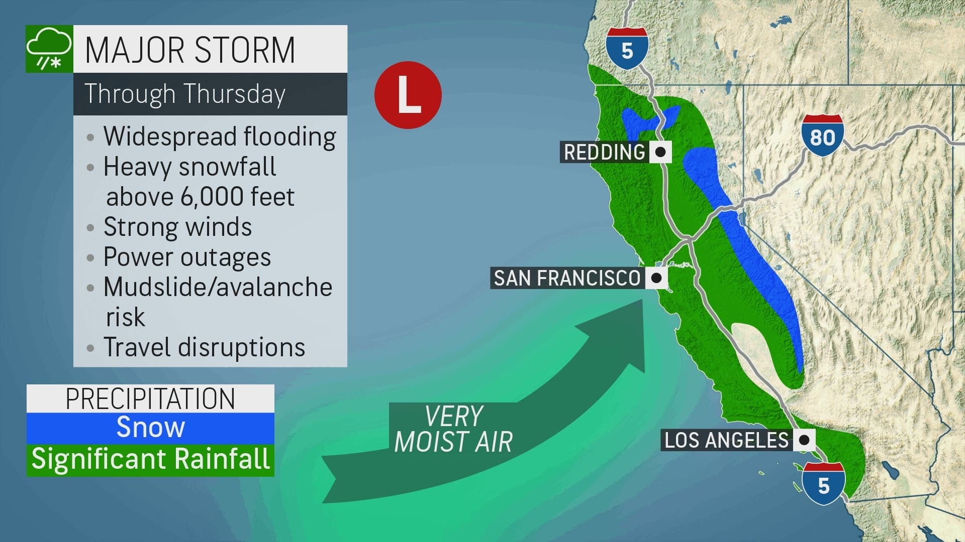
The National Weather Service has issued high wind warnings, high surf warnings, flood advisories and travel advisories up and down the state, while the Sierras expect more snow that will be measured in feet, not inches.
"Caltrans districts statewide are coordinating with local & state officials to assist with this latest storm system. TRAVEL IS NOT RECOMMENDED," the agency tweeted Tuesday.
Since 9 a.m. Wednesday, the California Highway Patrol reports that in the Bay Area water is completely covering some roads, new mudslide has started, an interstate highway road sign blew down, and high winds are hampering travel on bridges.
CHP reports indicated roadways were flooding in the Southland, as well.
In the Central Valley, levee inspections are underway after multiple breaches occurred following the New Year’s Eve storm, flooding farms and fields, highways and roads.
The heavy rainfall and unusually cold temperatures are expected to continue through Friday when waves generated by the powerful Pacific storm are expected to peak at 8 to 15 feet, potentially shutting down or damaging piers up and down the coast.
The rain will be accompanied by gusting winds. Gusts were expected to reach 60 mph in the mountains Wednesday afternoon.
For up-to-date forecasts, check AccuWeather.
RELATED:
- Powerful Storm Triggers Peninsula School District Closure
- San Francisco Public Works Runs Out Of Sandbags As Storm Strikes
- Large Power Outage Hits Berkeley
- Oakland, Alameda Ferry Routes Suspended For Wednesday Due To Storm
- City of Danville Declares Emergency Ahead Of Storm
- Sierra Nevada Snowpack At Above Average Levels Thanks To Winter Storms
- Flooding Damages Oakland Zoo; Closed For Weeks
- Rock, Mudslides Lead To Road Closures Throughout Contra Costa County
Get more local news delivered straight to your inbox. Sign up for free Patch newsletters and alerts.