Weather
Enough Already: One More Day Of Rain, Flooding
Rain returns today with urban and minor river flooding possible, particularly in the North Bay: NWS

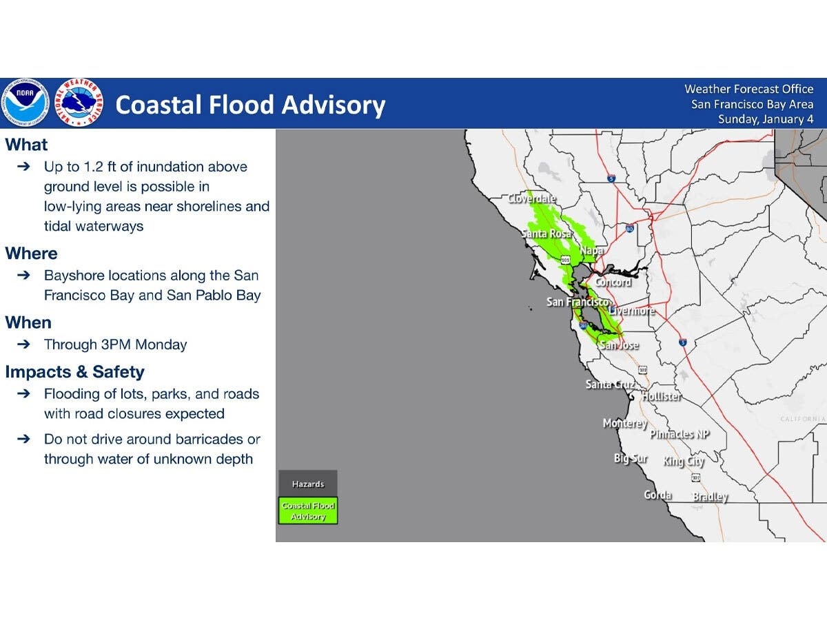
BAY AREA, CA — The Bay Area braced for another day of coastal flooding as king tides, a storm surge, and returning rain prompt the National Weather Service to extend a coastal flood advisory, with low-lying shoreline areas, roads and parks at risk of inundation before drier weather arrives later this week.
They were not disappointed.
A day of flooding and storm surges besieged Northern California.
Find out what's happening in San Franciscofor free with the latest updates from Patch.
The National Weather Service issued a coastal flood advisory until 3 p.m. and warned that rain would return today, bringing the potential for urban and minor river flooding, particularly in the North Bay.
Authorities issued a flood advisory until 6:30 p.m. from Cotati to Healdsburg in Sonoma County caused by flooding from downpours in low-lying areas and spots with poor drainage.
Find out what's happening in San Franciscofor free with the latest updates from Patch.
In particular, officials warned residents to beware of water over roadways. River and stream flows were elevated.
Between 1 and 2.5 inches of rain fell before 1 p.m. with more expected.
The flood advisory included Santa Rosa, Rohnert Park, Windsor, Healdsburg, Sebastopol,
Cotati, Tomales, Larkfield-Wikiup, Dillon Beach, Roseland, Forestville, Guerneville, Occidental, Graton, Monte Rio, and Bodega Bay.
Marin was hard hit by ongoing rainfall. The county received a torrential downpour, causing major flooding as roads closed and 911 services were disrupted.
Flooding at the AT&T communications hub knocked out 911 services.
All residents are warned to avoid flooded areas. Motorists who encounter flooded roads should immediately turn around.
However, change is coming, said National Weather Service forecasters, who said they expect drier, more stable air moving in this week.
Tuesday is a transition day between the wet stormy pattern that haunted the Bay Area for the last week and much drier weather that arrives in earnest on Wednesday, according to forecasts.
Forecasters warned not to be surprised to see a couple of showers on Tuesday, but nothing like the last few days.
Clouds arrive mid-week, but skies clear by Thursday. Clear nights will bring cold mornings, with interior temperatures dropping into the 30s for the first time since late December.
In the meantime, mariners should stay alert. High tide is expected in San Francisco at 12:08 p.m. today. A low-pressure system over the coastal waters will result in rain, a slight chance of thunderstorms, increasing south winds, including southerly gales over the southern inner coastal waters and the Monterey Bay today to this evening. Winds ease late tonight, while showers continue through Tuesday morning. Seas will remain moderate to rough today until this evening, forecasters said.
RELATED:
Weekend Of Storms, Flooding Wreaks Havoc On Marin County
911 Services Restored In Marin County Following Flooding At AT&T Communications Hub: Police
Get more local news delivered straight to your inbox. Sign up for free Patch newsletters and alerts.