Weather
CT Weather: Up To 18 Inches Of Snow Forecast Sunday, Sleet Likely For The Coast
A massive storm will cause major impacts on Connecticut beginning Sunday morning. Here are new details on how much snow to expect and when.

Snow accumulation estimates are dropping in southern Connecticut, especially near the coast, but this isn't good news. Now, more sleet and ice is expected to fall on top of heavy snow, 8 to 12 inches, according to the National Weather Service.
"Quick update to snow accumulation forecasts Sun-Mon to reflect higher confidence in a period of sleet...," the weather service said. "The rest of the forecast remains on track. Snow starts late Sunday morning/early Sunday afternoon. The period of heaviest snow (chance for 1+"/hour) is Sunday afternoon through midnight. Snow then becomes lighter late Sunday night and Monday as it tapers off through the day from west to east."
The revised snow map from the National Weather Service shows 8 to 12 inches of snow at the coast and eastern parts of the state.
Find out what's happening in Across Connecticutfor free with the latest updates from Patch.
"Heavy snow is expected Sunday morning into Sunday evening, transitioning to heavy wintry mix for the city/coast Sunday afternoon/evening," the weather service said. "Slightly reduced snowfall amounts and increased sleet accumulation for city/coast, with an earlier forecast wintry mix transition Sun afternoon into early evening."
The transition from snow to sleet is forecast between 3 p.m. and 7 p.m. Sunday from south to north.
Find out what's happening in Across Connecticutfor free with the latest updates from Patch.
Initial snow estimates for southern Connecticut this morning showed 12 to 16 inches of snow, and now it's down slightly to 10 to 16 inches of snow. There is no change for Hartford, Tolland, Windham, and Litchfield counties where 12 to 18 inches of snow is expected.
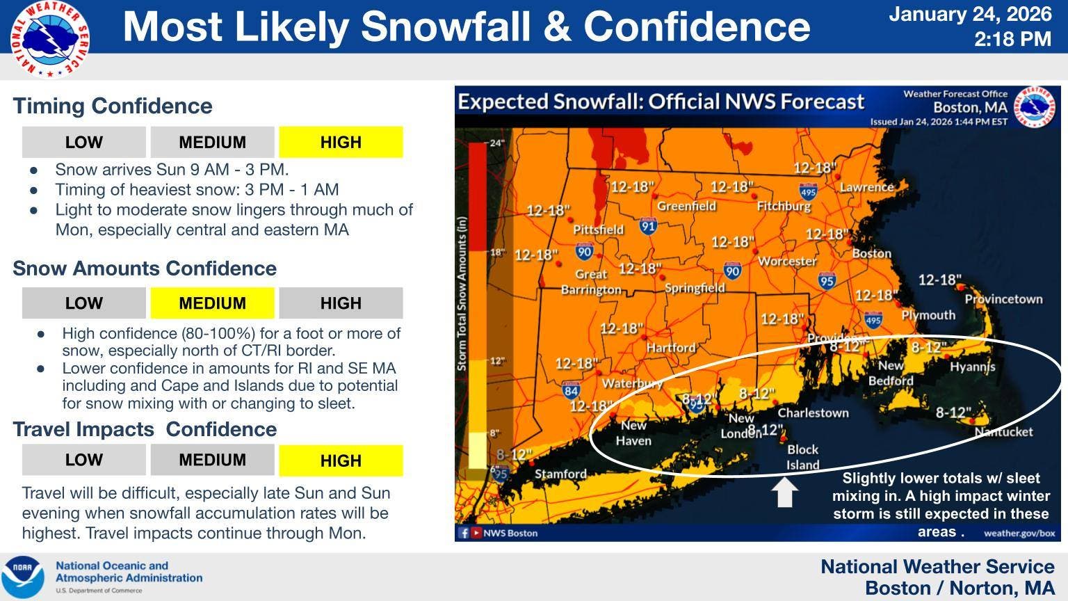
image via National Weather Service
⚠️ Plan ahead. Due to Winter Storm Fern, the airport will be closed from Sunday morning (1/25) through Monday morning (1/26). Check directly with your airline for the latest updates. pic.twitter.com/YbFQQEV4ch
— Tweed New Haven Airport (@FlyTweed) January 24, 2026
Original post filed this morning: A winter storm warning is in effect for a foot or more of snow across the entire state of Connecticut.
Some sleet may mix in along the immediate shoreline, and whatever does fall from this massive storm will stick around as temperatures will remain well below freezing for the week ahead.
Southern Connecticut snow details:
A winter storm warning is in effect from 3 a.m. Sunday to 6 p.m. Monday. "Heavy snow expected. Total snow accumulations between 12 and 16 inches. Sleet may briefly mix in with the snow Sunday night near the Connecticut coast...," according to the National Weather Service.
Northern Connecticut snow details:
A winter storm warning is in effect from 7 a.m. Sunday to 8 p.m. Monday. "Heavy snow expected. Total snow accumulations between 13 and 19 inches. Winds gusting as high as 35 mph," according to the National Weather Service.
Litchfield County snow details:
A winter storm warning is in effect from 7 a.m. Sunday to 7 p.m. Monday. "Heavy snow expected. Total snow accumulations between 12 and 18 inches....," according to the National Weather Service.
Timeline for the heaviest snow from the National Weather Service:
"Heavy snow expected Sunday morning into Sunday night, transitioning to wintry mix for the...coast Sunday evening/night. Prepare for a major winter storm, bringing major disruption to transportation and daily life Sunday into Sunday Night from heavy snowfall/wintry mix, high snowfall rates, and near whiteout conditions. Lingering significant impacts into Monday," the weather service said.
We can expect snowfall rates up to 2 inches per hour Sunday into Sunday night. The snow will be dry and powdery, potentially becoming wetter Sunday evening, especially near the coast where sleet may mix in.
The timeline for the heaviest snow will be late Sunday morning into Sunday night, and light snow is forecast to continue into Monday. Winds could gust up to 25 mph, according to the weather service.
In a snow map, the National Weather Service shows on the high end, Connecticut could see 17 inches and on the low-end the coast could see as little as six inches. Overall, the weather service is predicting 12 to 18 inches statewide.
Read More:
- School Bus Driver Arrested After Students Fight During Ride: Police
- Mother Searches For Answers After Teen Son’s Killing
- CT Taxpayers May See Bigger 2025 Federal Income Tax Returns
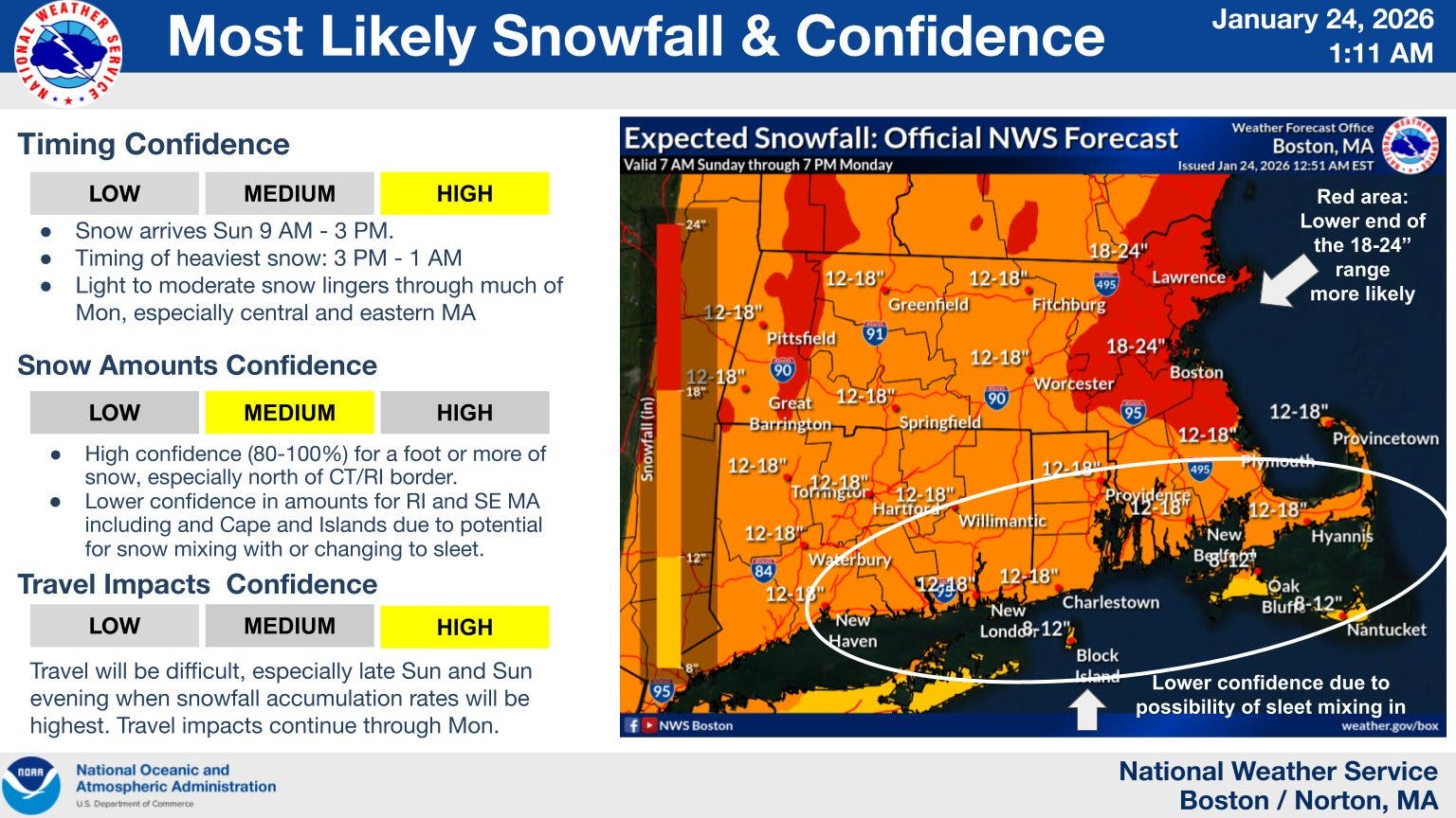
image via the National Weather Service
image via the National Weather Service
Connecticut's weather experts predictions
"As we see it now, precipitation will be all snow from beginning to end (and of the fluffy variety for inland CT). The chance for mixing is lower but not completely zero along the immediate shoreline. The chance for mixing with sleet is possible between 8-11pm and that’s it, so not much of an impact regarding holding back snowfall amounts. By the time it’s all done, expect 12-18″ statewide. Isolated totals of 19″ or 20″ cannot be ruled out," WFSB 3 TV meteorologists said.
WTNH News 8 shows 12 to 18 inches of snow for 90 percent of the state and 10 to 14 inches of snow on the immediate coast east of New Haven.
"The timing looks to be between around 9 AM Sunday-11AM Monday. The worst of the storm, where 2-3″ per hour snowfall rates will occur is during the late afternoon and evening hours Sunday. Most of the accumulation is done with by midnight with an inch or two possible with the back end early Monday AM Sleet may make its way along the immediate shore, which is why a touch less snow is expected there," WTNH News 8 meteorologists said.
NBC Connecticut is forecasting a general 10 to 18 inches of snow for Connecticut. Fox 61 is predicting 10 to 16 inches of snow.
Whatever snow falls isn't going anywhere for a while
If you get a chance on Monday, you'll want to move the snow as best you can, because bitterly cold temperatures will dominate the forecast for the entire week and everything will freeze.
"...the cold stays locked in place, with highs in the mid-20s both Tuesday and Wednesday. With a clear sky and a calmer wind, we’re expected temperatures on Wednesday morning to fall into the 0-5 degree range! Thursday appears mostly cloudy with perhaps some isolated snow showers. Friday will be in the 20s again with a bit more sunshine," WFSB 3 TV meteorologists said.
Get more local news delivered straight to your inbox. Sign up for free Patch newsletters and alerts.