Weather
Severe Thunderstorms Forecast In CT: Here's When, What To Know
There are several chances for storms this week, find out the latest prediction, according to meteorologists.

Temperatures are expected to soar into the low 80s today, and there is also a chance for severe thunderstorms, according to meteorologists.
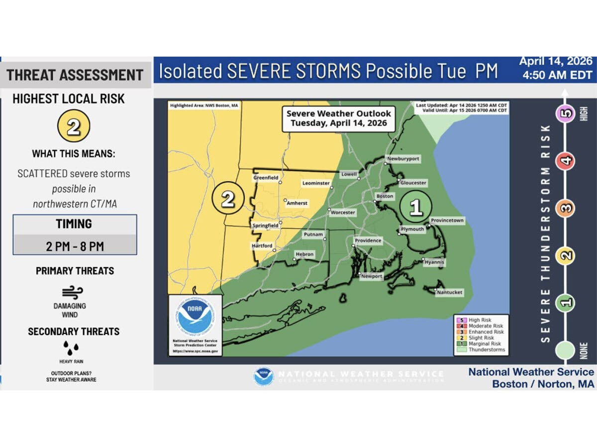
The National Weather Service in Boston warns “strong to severe thunderstorms are possible” between 2 p.m. and 8 p.m. Tuesday, with the highest risk in the northwest section of Connecticut.
“Damaging winds may down trees and powerlines,” the National Weather Service said.
Find out what's happening in Across Connecticutfor free with the latest updates from Patch.
Any storms will weaken as they track eastward this evening, forecasters said.
The National Weather Service in New York predicts today will be the warmest of the year so far, with temperatures reaching into the 70s and 80s for most. This is about 20 degrees above normal for this time of year, its forecasters said.
Find out what's happening in Across Connecticutfor free with the latest updates from Patch.
WTNH also reports it will be much warmer today, and the warmth will stick around for a few days.
Today will be mostly sunny and dry, according to WTNH, which predicts storms are possible as the day progresses. Strong wind gusts are possible, according to WTNH.
“Watch for a severe thunder threat this evening! Most daylight periods stay dry, but a few late day/evening and night showers/storms are possible as humidity levels begin to increase a bit,” WTNH reports.
WTNH anticipates any evening showers and storms will move out between 10 p.m. and midnight tonight.
WFSB is calling today a “First Alert Weather Day,” due to the storm threat this evening.
WFSB predicts highs today will be around 80 inland and in the 60s and 70s along the shore.
“We’ll start the day dry and bright, but toward and after the evening commute storms will be possible,” WFSB reports. “Those that develop and move into/thru CT could produce not only lightning but a gusty/damaging wind.*
Read More:
- Self-Driving Car Crashes, Police Say
- High School Student Was Detained By ICE Due To Paperwork Error: Reports
- Bear Roams Through Neighborhoods, Rummaging Through Trash
Here are the forecast details for northern Connecticut via the National Weather Service:
Today: A chance of showers, with thunderstorms also possible after 5 p.m. Mostly sunny, with a high near 82. Light south wind increasing to 8 to 13 mph in the afternoon. Chance of precipitation is 30%. New rainfall amounts between a tenth and quarter of an inch, except higher amounts possible in thunderstorms.
Tonight: A chance of showers and thunderstorms, mainly before 9 p.m. Partly cloudy, with a low around 59. South wind 3 to 8 mph. Chance of precipitation is 30%. New precipitation amounts between a tenth and quarter of an inch, except higher amounts possible in thunderstorms.
Wednesday: A chance of showers, with thunderstorms also possible after 5 p.m. Partly sunny, with a high near 84. Light southwest wind increasing to 5 to 10 mph in the morning. Chance of precipitation is 40%. New rainfall amounts of less than a tenth of an inch, except higher amounts possible in thunderstorms.
Wednesday Night: A chance of showers and thunderstorms. Mostly cloudy, with a low around 61. Southwest wind 3 to 6 mph. Chance of precipitation is 50%. New precipitation amounts between a tenth and quarter of an inch, except higher amounts possible in thunderstorms.
Thursday: A chance of showers, mainly after 2 p.m. Partly sunny, with a high near 84. Light south wind becoming southwest 5 to 10 mph in the morning. Chance of precipitation is 30%.
Thursday Night: A chance of showers, mainly before 8 p.m. Mostly cloudy, with a low around 60. West wind 3 to 7 mph. Chance of precipitation is 30%.
Friday: Showers likely, mainly after 5 p.m. Partly sunny, with a high near 78. Light and variable wind becoming north 5 to 7 mph in the morning. Chance of precipitation is 60%.
Friday Night: A chance of showers before 1 a.m. Mostly cloudy, with a low around 53. Northeast wind around 6 mph. Chance of precipitation is 40%.
Saturday: Mostly cloudy, with a high near 68. Northeast wind 6 to 8 mph.
Here are the forecast details for southern Connecticut via the National Weather Service:
Today: Mostly sunny, with a high near 78. Calm wind becoming south 5 to 9 mph in the afternoon.
Tonight: Partly cloudy, with a low around 55. South wind around 6 mph becoming calm in the evening.
Wednesday: A chance of showers between 2 p.m. and 5 p.m., then a chance of showers and thunderstorms after 5 p.m. Mostly sunny, with a high near 79. Calm wind becoming south 5 to 8 mph in the afternoon. Chance of precipitation is 30%.
Wednesday Night: A chance of showers and thunderstorms. Mostly cloudy, with a low around 56. Light and variable wind. Chance of precipitation is 40%.
Thursday: A slight chance of showers before 8 a.m., then a slight chance of showers after 2 p.m. Partly sunny, with a high near 75. Calm wind becoming south 5 to 8 mph in the morning. Chance of precipitation is 20%.
Thursday Night: Mostly cloudy, with a low around 56.
Friday: A 50 percent chance of showers after 8 a.m. Partly sunny, with a high near 73.
Friday Night: Mostly cloudy, with a low around 50.
Saturday: Mostly cloudy, with a high near 64.
Get more local news delivered straight to your inbox. Sign up for free Patch newsletters and alerts.