Weather
Snow Map Released For Storm Headed To Connecticut
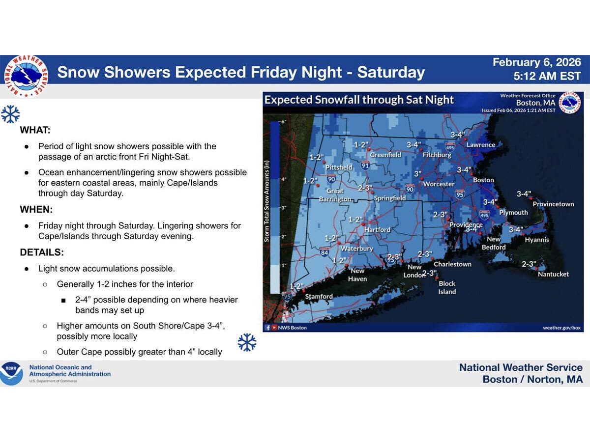
Find out how much snowfall to expect late tonight through Saturday, according to meteorologists.

Snow is expected to arrive in Connecticut tonight, and meteorologists are predicting between one and three inches will fall.
The National Weather Service’s Boston office is forecasting western Connecticut will get between one and two inches, while eastern Connecticut will see more, or two to three inches.
It predicts snow will begin very late tonight and last through Saturday, with the passage of an arctic front.
Find out what's happening in Across Connecticutfor free with the latest updates from Patch.
Lingering snow showers are possible near the coast into Saturday night, according to the National Weather Service.
“A few inches of snow accumulation is possible across much of southern New England,” it reported.
Find out what's happening in Across Connecticutfor free with the latest updates from Patch.
WFSB is predicting between one and three inches of snow will fall in Connecticut by Saturday afternoon.
“We’ll be monitoring the possible development of bands of moderate snow connected to an area of low pressure that will be developing offshore and moving away from Southern New England that could lead to locally higher amounts,” WFSB reports.
WTNH is reporting Saturday will be snowy at times, with most areas getting between one and three inches, though up to four inches are possible in eastern areas of the state.
Read More:
- Prominent Business Announces Mass Layoffs
- Student Arrested, Possessed Gun In CT School: Police
- Police Sergeant In Connecticut Arrested, Officials Say
Dangerously cold temperatures
After the strong cold front passes, it will be dangerously cold, according to the National Weather Service. Wind chills could make it feel as cold as 35 below Saturday night and into early Sunday.
Residents are urged to bundle up, to avoid the possibility of frostbite.
There is a wind advisory in effect from Saturday morning through midnight, and an extreme cold warning from Saturday afternoon through about mid-day on Sunday. Wind gusts could reach up to 50 miles per hour, according to the National Weather Service, which could mean downed limbs and some power outages.
According to WFSB, early Sunday morning will feel the worst due to the cold and wind, but the wind will calm down as the day progresses, bringing wind chill values to between -5 and -15.
The weather will improve on Monday and Tuesday. Both days are predicted to be sunny, with daytime high temperatures in the mid-20s to low-30s. The long-range forecast is calling for a chance of snow again on Wednesday, according to the National Weather Service.
Here are the forecast details for southern Connecticut via the National Weather Service:
Today: Mostly cloudy, with a high near 30. Wind chill values between 10 and 20. North wind around 6 mph becoming southeast in the afternoon.
Tonight: Snow, mainly after 10 p.m. Low around 20. Light and variable wind becoming west around 5 mph. Chance of precipitation is 80%. New snow accumulation of less than a half inch possible.
Saturday: Snow, mainly before 1 p.m. Temperature falling to around 11 by 5 p.m. Wind chill values between -10 and zero. Blustery, with a northwest wind 8 to 13 mph increasing to 18 to 23 mph in the afternoon. Winds could gust as high as 43 mph. Chance of precipitation is 80%. New snow accumulation of less than a half inch possible.
Saturday Night: Mostly cloudy, then gradually becoming mostly clear, with a low around 2. Wind chill values between -10 and -15. Blustery, with a northwest wind 14 to 22 mph, with gusts as high as 43 mph.
Sunday: Sunny and cold, with a high near 18. Northwest wind 13 to 15 mph, with gusts as high as 29 mph.
Sunday Night: Mostly clear, with a low around 4.
Monday: Sunny, with a high near 25.
Monday Night: Mostly clear, with a low around 11.
Tuesday: Sunny, with a high near 31.
Tuesday Night: Mostly cloudy, with a low around 18.
Wednesday: A chance of rain and snow. Mostly cloudy, with a high near 34. Chance of precipitation is 40%.
Here are the forecast details for northern Connecticut via the National Weather Service:
Today: Mostly cloudy, with a high near 29. Calm wind.
Tonight: Snow likely, mainly after 2 a.m. Cloudy, with a low around 15. Calm wind. Chance of precipitation is 70%. New snow accumulation of less than one inch possible.
Saturday: Snow, mainly before 4 p.m. High near 25. Wind chill values as low as -2. Blustery, with a northwest wind 6 to 11 mph increasing to 15 to 20 mph in the afternoon. Winds could gust as high as 37 mph. Chance of precipitation is 90%. New snow accumulation of 1 to 2 inches possible.
Saturday Night: Mostly cloudy, then gradually becoming mostly clear, with a low around -2. Wind chill values as low as -21. Blustery, with a northwest wind 16 to 20 mph, with gusts as high as 37 mph.
Sunday: Sunny, with a high near 15. Northwest wind around 15 mph, with gusts as high as 30 mph.
Sunday Night: Mostly clear, with a low around -2. Northwest wind 6 to 10 mph, with gusts as high as 20 mph.
Monday: Sunny, with a high near 24. Northwest wind 6 to 9 mph.
Monday Night: Mostly clear, with a low around 2. Northwest wind 3 to 6 mph.
Tuesday: Sunny, with a high near 31. North wind 3 to 6 mph.
Tuesday Night: Mostly cloudy, with a low around 12. Light and variable wind.
Wednesday: A chance of snow. Mostly cloudy, with a high near 34. Light and variable wind becoming west 5 to 7 mph in the afternoon. Chance of precipitation is 40%.
Get more local news delivered straight to your inbox. Sign up for free Patch newsletters and alerts.