Weather
Thunderstorms, 40+ MPH Wind Gusts, Flooding Concerns Across CT Monday
Power outages are possible with the storm. Find out the latest forecast details and timing, according to meteorologists.

It is going to be a wet and windy day today, with the potential for thunderstorms and power outages, according to meteorologists.
The National Weather Service in New York predicts between one and 2.5 inches of rain as the strong frontal system passes through.
Flood watches and wind advisories are in effect for the state.
Find out what's happening in Across Connecticutfor free with the latest updates from Patch.
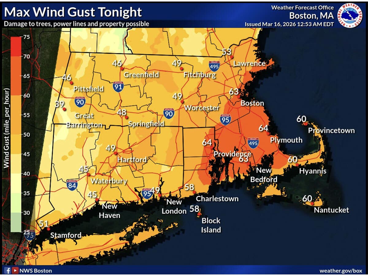
50 mph wind gusts possible
The wind will ramp up as the day progresses, according to the National Weather Service.
Find out what's happening in Across Connecticutfor free with the latest updates from Patch.
It is predicting wind gusts of 35 to 50 miles per hour, with isolated gusts to 55 miles per hour. “Strong to possibly severe” thunderstorms will move through the state also, the National Weather Service said.
The flood watch is in effect through Tuesday morning due to excessive rainfall, and the runoff could cause rivers, creeks, and streams to overflow.
The wind advisories, also in effect through early Tuesday, warn of winds of up to 30 miles per hour and gusts of up to 50-55 miles per hour. Power outages are possible, according to the advisory.
Heavy rain forecast
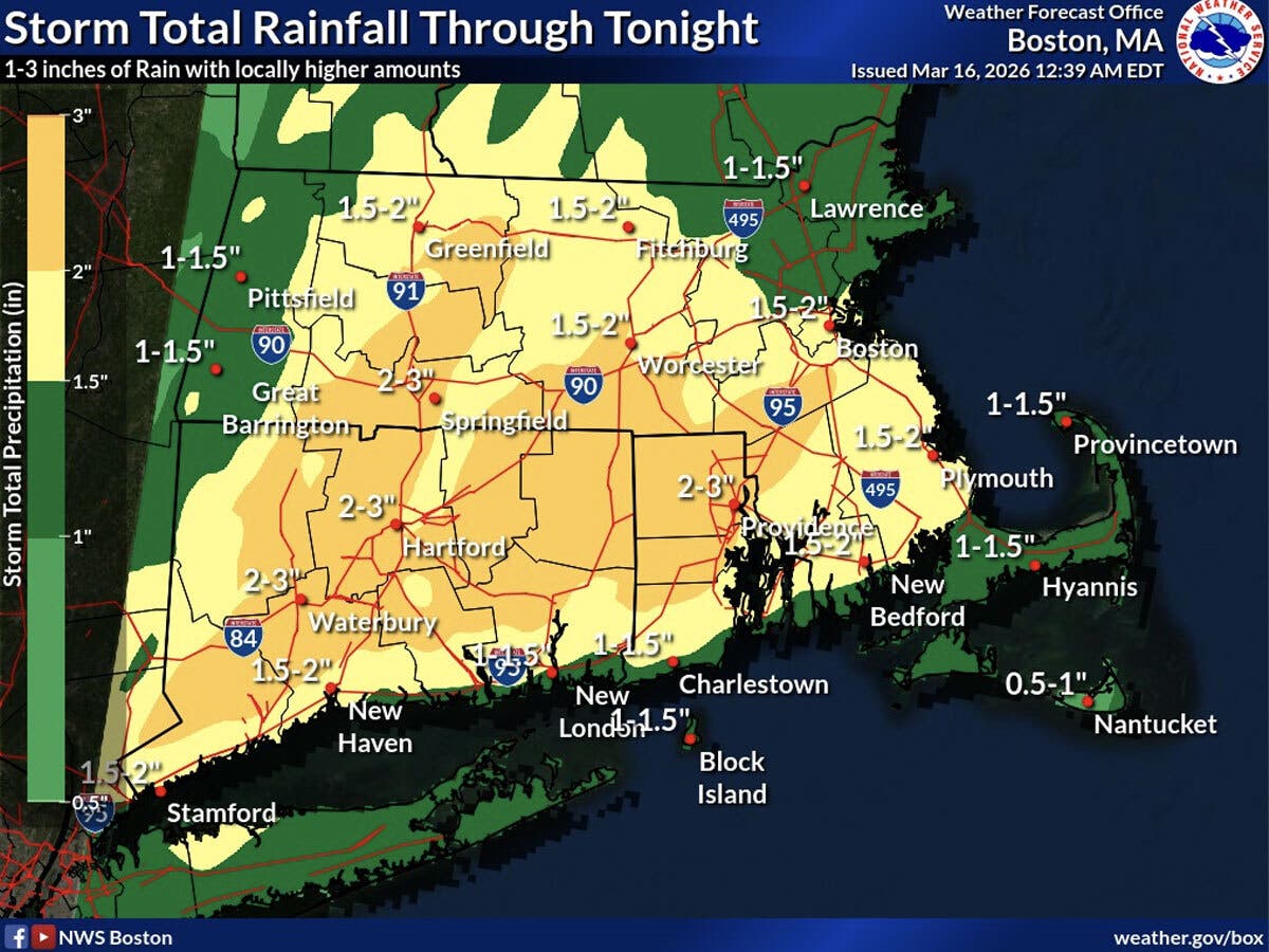
WFSB is calling today a First Alert Weather Day due to the wet and windy conditions. Its meteorologists predict between one and three inches of rainfall.
“The wind really cranks up this afternoon, gusting 40mph or more at times,” WFSB reports. “Keep in mind, with the rapid snow melt less than a week ago, river levels are running quite high - so river/stream flooding is a possibility, as well as in areas with poor drainage.”
WTNH is predicting strong, gusty winds and moderate to heavy rain today from the system, along with flooding. It anticipates gusts of 30-55 miles per hour and isolated 60 mile per hour gusts causing some power outages.
The temperature today will be on the mild side, with highs in the upper 50s. Once the system passes through, Tuesday will be sunny, with daytime highs around 40, according to the National Weather Service.
Read More:
- Details Released For Highly Anticipated Waterfront Restaurant, Venue
- Well-Known Toy Retailer That Sells Labubu To Open At Shopping Destination
- Premium Ice Cream Franchise Expanding
Here are the forecast details for southern Connecticut via the National Weather Service:
Today: Showers and possibly a thunderstorm. Areas of fog. High near 59. South wind 11 to 17 mph, with gusts as high as 32 mph. Chance of precipitation is 90%. New rainfall amounts between a quarter and half of an inch possible.
Tonight: Showers and possibly a thunderstorm before 2 a.m., then a chance of showers. Areas of fog before 2 a.m. Low around 36. South wind 14 to 18 mph becoming west after midnight. Winds could gust as high as 45 mph. Chance of precipitation is 100%. New rainfall amounts between a quarter and half of an inch possible.
Tuesday: Mostly sunny, with a steady temperature around 39. West wind 11 to 14 mph, with gusts as high as 24 mph.
Tuesday Night: Partly cloudy, with a low around 23. West wind 7 to 9 mph.
Wednesday: Increasing clouds, with a high near 38. West wind around 5 mph becoming light and variable.
Wednesday Night: Mostly cloudy, with a low around 28.
Thursday: Partly sunny, with a high near 44.
Thursday Night: Mostly cloudy, with a low around 33.
Friday: Mostly sunny, with a high near 51.
Here are the forecast details for northern Connecticut via the National Weather Service:
Today: Rain and possibly a thunderstorm. Patchy fog before 3 p.m. High near 63. South wind 13 to 18 mph, with gusts as high as 33 mph. Chance of precipitation is 100%. New rainfall amounts between three quarters and one inch possible.
Tonight: Rain and possibly a thunderstorm before 2 a.m., then rain likely. Patchy fog between 7 p.m. and 3 a.m. Low around 34. Windy, with a south wind 21 to 26 mph, with gusts as high as 48 mph. Chance of precipitation is 100%. New rainfall amounts between three quarters and one inch possible.
Tuesday: Mostly sunny, with a high near 42. West wind around 16 mph, with gusts as high as 30 mph.
Tuesday Night: Partly cloudy, with a low around 22. West wind 8 to 11 mph, with gusts as high as 21 mph.
Wednesday: Mostly sunny, with a high near 39. Northwest wind around 6 mph.
Wednesday Night: Mostly cloudy, with a low around 25. South wind 3 to 6 mph.
Thursday: Partly sunny, with a high near 46. South wind 5 to 11 mph.
Thursday Night: Mostly cloudy, with a low around 30. South wind 5 to 7 mph.
Friday: Partly sunny, with a high near 52. West wind 6 to 11 mph.
Get more local news delivered straight to your inbox. Sign up for free Patch newsletters and alerts.