Politics & Government
Sarasota Tornado Damage Estimates Up to $12 Million
The figure climbed dramatically from the weekend's initial assessment of $3 million after more properties were toured.

SARAOTA, FL — Sunday’s tornado that cut a 1.14-mile path from Siesta Key into Sarasota left an estimated $12 million in damage in its wake, according to county officials.
That estimate involves approximately 60 structures, both commercial and residential, that were impacted when the EF-2 tornado touched down at 3:17 a.m. with estimated peak winds of 132 mph, county spokesman Jason Bartolone confirmed Tuesday. The county’s estimate as of Tuesday morning was just shy of the $12 million mark.
Property owners impacted by the Jan. 17 storm are urged to contact their insurance companies to file claims. Florida’s Chief Financial Officer, Jeff Atwater, has also offered his office’s assistance in helping property owners understand their insurance coverage and file claims. Residents in need of assistance may call 1-877-693-5236, according to Atwater’s post-tornado tweet.
Find out what's happening in Sarasotafor free with the latest updates from Patch.
See Also:
- Tampa Bay Tornadoes: Damage Estimates Released
- Victims Identified After Tampa Bay Tornado Kills 2, Injures 5
- Duette Tornado: How To Help The Victims
- Florida Tornadoes: What You Need to Know
- Severe Storms, Tornadoes in Tampa Bay’s Winter Forecast
- Weather Radios: Deals On Tools For Tracking Florida’s Severe Storms
“This is the type of damage we can expect from El Nino type tornadoes,” weather service meteorologist Tyler Fleming told Patch of Sunday’s storms. When this weather pattern is present, it’s “very common for these tornadoes to happen in the middle of the night.”
Find out what's happening in Sarasotafor free with the latest updates from Patch.
“Generally, for Florida an El Nino winter means cooler than normal temperatures and wetter than normal (conditions),” weather service meteorologist Rick Davis said in an earlier interview.
The El Nino weather pattern arises when the sea surface temperatures rise in the equatorial Pacific Ocean and impact the northern hemisphere, Davis explained. When that happens, the southern branch of the Jetstream becomes more active. That enables systems to move across the Pacific, across the southern states, through the Gulf of Mexico and into Florida.
“Because the storm systems have a more southern latitude, they’re expected to produce more rain for us and then with that southern storm track more cold fronts (could move in), increasing the chances for severe weather,” Davis said.
While much of this week is anticipated to be chilly, but clear, Friday is expected to bring more storms and thunderstorms to the region. As of Tuesday morning, the weather service said those storms could be strong, but it was too early to tell if severe conditions will present.
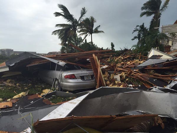
Photo of Sarasota tornado damage courtesy of Sarasota County government
Get more local news delivered straight to your inbox. Sign up for free Patch newsletters and alerts.