Weather
Tropical Storm Could Bring Heavy Rain To GA: See Latest Track, Timing
A rainstorm in the Gulf, off the TX coast, could develop into the first tropical storm of hurricane season. See what this means for GA.

All eyes are on the western Gulf, where the first tropical storm of the season could develop this week.
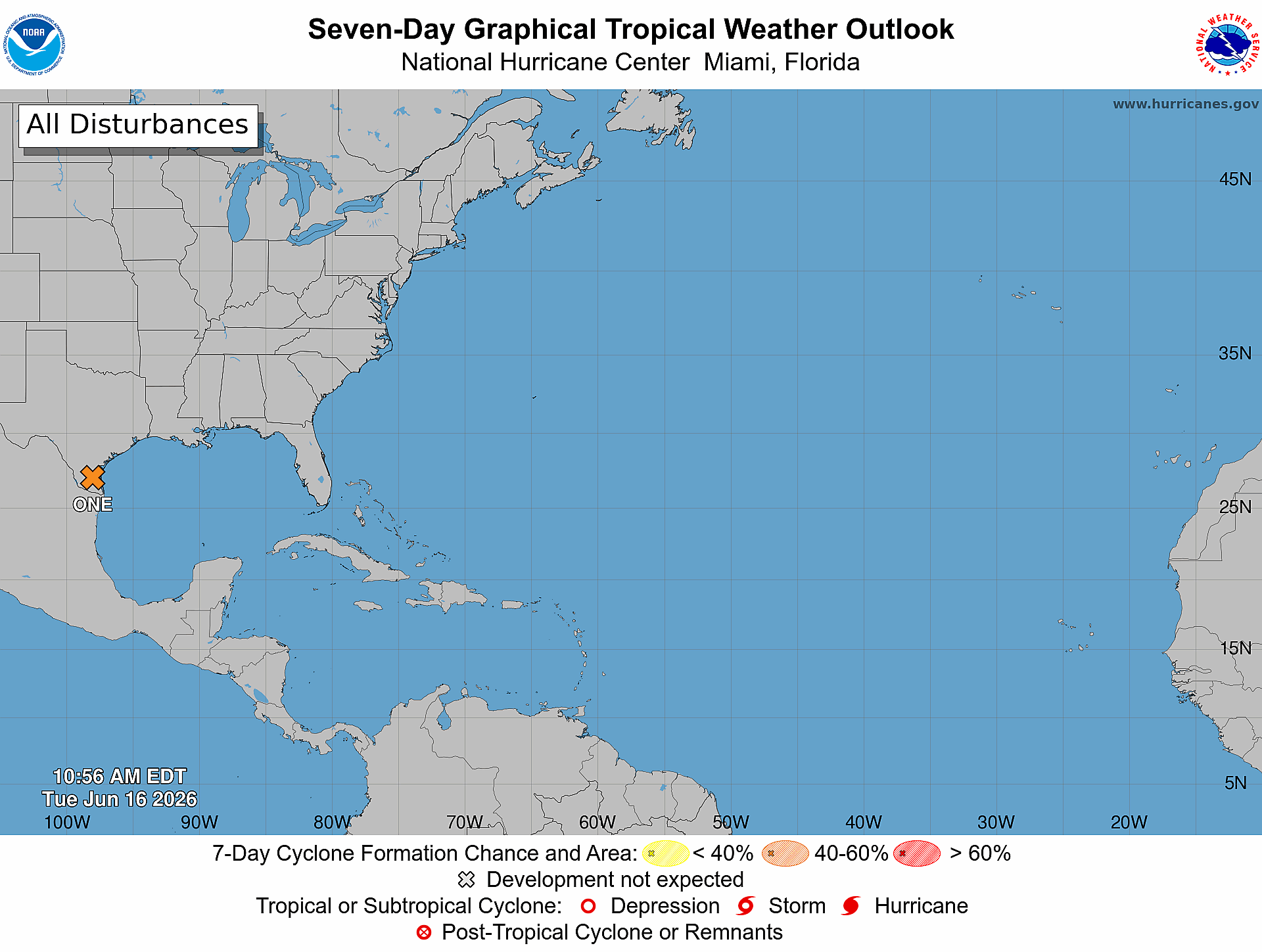
Experts are watching Potential Tropical Cyclone One, a broad area of low pressure that popped up in the southwestern Gulf last week and moved across northern Mexico and inland over south Texas, the National Hurricane Center said.
If this area develops into the first tropical storm of the season, it would be named Arthur.
Find out what's happening in Across Georgiafor free with the latest updates from Patch.
As it moves across the Southeast, it's expected to bring heavy rains into Georgia, experts said.
This system originates from former eastern Pacific Tropical Storm Cristina, a tropical wave of low pressure from Africa, a stalled weather front and the jet stream, AccuWeather forecasters said.
Find out what's happening in Across Georgiafor free with the latest updates from Patch.
The tropical system, currently producing a large area of disorganized showers and thunderstorms, has a 60 percent chance of strengthening into a tropical depression or storm over the next two days, the NHC said.
"The key to whether this tropical rainstorm will focus enough wind energy to become a named tropical storm ... will hinge on its proximity to warm waters of the Gulf," AccuWeather Lead Hurricane Expert Alex DaSilva said.
The system is expected to move northeast along the Texas coast, possibly emerging over the northwestern Gulf by Tuesday night, forecasters said.
"While tropical storms have formed over swampy areas along the Gulf, ideally, the center of this rainstorm would have to be over the Gulf for further organization and strengthening," DaSilva said.
The system will likely continue to strengthen throughout the day on Tuesday, the NHC said. “Environmental conditions are expected to be marginally conducive for the formation of a short-lived tropical storm late today or on Wednesday, especially if the system moves far enough offshore.”
Denis Phillips, chief meteorologist for Tampa Bay 28, wrote in a social media post, “Low pressure will move over the water today and will have a chance to develop before it moves back on-shore in Louisiana. Again, the threat of flooding, from rain, along the track of this system is the biggest concern. Much of this will likely occur well away from the coast.”
Because the system is currently so close to the coast, rapid intensification isn’t expected, forecasters added.
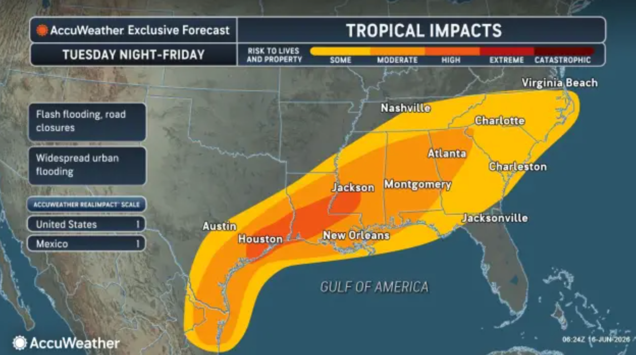
Whether it strengthens or not, the system will still likely bring heavy rain, gusty winds, coastal flooding, and “widespread, life-threatening flash, urban, and river flooding” to southern and eastern Texas, as well as parts of Louisiana and Mississippi, NHC meteorologists said.
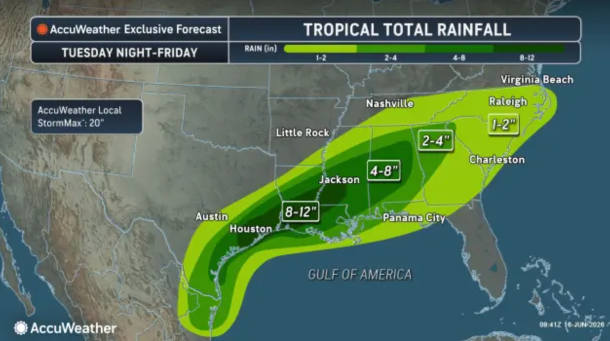
A broad zone from south Texas to eastern Alabama could see 4 to 8 inches of rain, with a substantial area getting as many as 8 to 12 inches, and even up to 20 inches in some parts, AccuWeather said.
Severe thunderstorms with gusty winds, coastal flooding, and the potential for tornadoes or waterspouts are also possible along parts of the northwestern Gulf Coast.
And as it moves northeast, it's expected to bring tropical weather, including heavy rains, to most of Georgia, through Friday, forecasters said.
See Also:
Get more local news delivered straight to your inbox. Sign up for free Patch newsletters and alerts.