Weather
MD Weather: Ice Possible Saturday Night, Hazardous Outlook
Rain will mix with a bit of ice in higher elevations of Maryland this weekend, with a chance of snow in next week's forecast, the NWS says.

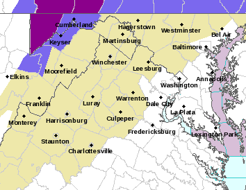
BALTIMORE, MD — Rain mixed with sleet and snow is possible in Maryland today, with some of the wintry mix accumulating before dawn on Sunday. The best odds for ice are in northern Baltimore County and far western Maryland, where a winter weather advisory is set to begin Saturday night.
A hazardous weather outlook has been issued for the Maryland portion of the Chesapeake Bay, Tidal Potomac River, and adjacent counties in central Maryland and northern Virginia as well as the District of Columbia. The outlook includes southern Baltimore, Prince George's, Anne Arundel, Charles, St. Marys, Calvert, and southeast Harford counties, according to the National Weather Service.
Less than half an inch of ice could fall in northern Baltimore County Saturday night, The Baltimore Sun reports. No snow is expected in the Baltimore region with high temperatures in the mid-40s during the day Saturday and high-30s Saturday night, according to Accuweather.com.
Find out what's happening in Annapolisfor free with the latest updates from Patch.
The Capital Weather Gang says rain could mix with sleet or even a snowflake late Saturday into Sunday morning. "As steadier stuff starts, it could include some sleet or a snowflake. Any risk of minor (very minor) accumulating wintry mix is well north and west of the (DC) area in general," the newspaper forecasts.
A dusting of snow or sleet is possible only on grassy or elevated surfaces in the Washington, D.C., metro, with some freezing rain north and west of the city, says The Washington Post's Capital Weather Gang.
Find out what's happening in Annapolisfor free with the latest updates from Patch.
While the weather in Maryland won't be ideal, we're dodging a much bigger mess just to the north. The National Weather Service has issued a winter storm watch for seven New Jersey counties with expected snow accumulation totals of 3 to 8 inches on Sunday and Monday. The storm could wreak enough havoc to make holiday travel a complete mess.
While Saturday afternoon will be overcast, precipitation will hold off until about 10 p.m. The next three days should be soggy for the state, not ideal weather for shopping, football or putting up Christmas lights.
Here's the latest forecast from the National Weather Service:
Saturday: Cloudy, with a high near 45. North wind around 5 mph becoming light and variable in the afternoon.
Saturday Night: Rain, mainly after 10pm. Low around 37. Calm wind becoming east 5 to 8 mph after midnight. Chance of precipitation is 100%. New precipitation amounts between a tenth and quarter of an inch possible.
Sunday: Rain, mainly before 4pm. High near 46. East wind 6 to 9 mph. Chance of precipitation is 100%. New precipitation amounts between a half and three quarters of an inch possible.
Sunday Night: A chance of rain before 7pm, then showers likely, mainly after 1am. Cloudy, with a low around 36. Northwest wind 6 to 9 mph. Chance of precipitation is 60%. New precipitation amounts of less than a tenth of an inch possible.
Monday: Rain and snow showers likely. Cloudy, with a high near 44. Northwest wind 6 to 13 mph, with gusts as high as 20 mph. Chance of precipitation is 60%.
Monday Night: A chance of snow showers. Cloudy, with a low around 31. Chance of precipitation is 30%.
Tuesday: Mostly sunny, with a high near 46.
Get more local news delivered straight to your inbox. Sign up for free Patch newsletters and alerts.