Weather
Flood Warning Extended For 5 Counties + Baltimore
Several roads and streams have flooded Sunday, the National Weather Service warns.


Five counties and Baltimore City remain under a flood warning until 3:30 a.m. Monday. According to the National Weather Service, flooding was ongoing across the region in central Maryland.
After 9 p.m. on Sunday, weather officials said that high water was closing multiple roads, and stream gauges indicated that minor flooding was occurring.
During a flood warning, drivers and pedestrians who come across roads covered with water of unknown depth should turn around; don't drown. In particular, authorities ask people to be cautious at night, when it is harder to recognize hazardous situations.
Find out what's happening in Baltimorefor free with the latest updates from Patch.
These areas are under the flood warning until 3:30 a.m., according to the National Weather Service:
- Anne Arundel County
- Baltimore City
- Baltimore County
- Carroll County
- Frederick County
- Howard County
These locations may experience flooding, according to the National Weather Service: Baltimore, Columbia, Frederick, Severn, Pikesville, Crofton, Middle River, Cockeysville, Westminster, Elkridge, Riviera Beach, Thurmont, Emmitsburg, Baltimore-Washington Airport, Fort Smallwood State Park, Sillery Bay, Harry Grove Stadium, Gibson Island, Millers Island and North Point State Park.
Find out what's happening in Baltimorefor free with the latest updates from Patch.
There is a coastal flood warning until 10 a.m. on Monday, Sept. 10, for Anne Arundel County.
Tides are expected to be 2 feet above normal along the Anne Arundel shoreline, with high tides at 6:16 a.m. and 6:39 p.m. Monday.
(WARNING EXPIRED) — As some waterways have begun spilling out of their banks, the National Weather Service has extended its flood warning for much of Maryland. Originally, officials issued a flood warning Sunday morning that was set to expire at 3:30 p.m.
Now the flood warning is in effect until 9:30 p.m. on Sunday, Sept. 9.
About 2 to 3 inches of rain had already fallen, weather officials warned after 3 p.m. Sunday, and another inch was possible by the end of the evening.
These areas are under the flood warning until 9:30 p.m.:
- Anne Arundel County
- Baltimore City
- Baltimore County
- Carroll County
- Frederick County
- Harford County
- Howard County
- Montgomery County
Flooding was occurring along the Bruce Pipe Creek in Bruceville, according to the National Weather Service. The gauge along the Patapsco River in Elkridge indicated high water too, with additional high water reported on Furnace Avenue and Hammonds Ferry Road nearby.
SEE ALSO: Flooding Closes Part Of Patapsco State Park
These locations may experience flooding, according to weather officials: Baltimore, Columbia, Germantown, Frederick, Bowie, Severn, Pikesville, Crofton, Middle River, Cockeysville, Westminster, Elkridge, Damascus, Aberdeen, Havre de Grace, Riviera Beach, Thurmont, Emmitsburg, Aberdeen Proving Ground and BWI.
There is a coastal flood warning until 10 a.m. on Monday, Sept. 10, for Anne Arundel County.
Tides are expected to be 1 to 2 feet above normal along the Anne Arundel shoreline, with high tides at 5:44 p.m. Sunday and 6:16 a.m. Monday.
Water may overflow through storm drains, approaching Dock Street businesses, the Maritime Museum and Boyer Road near the Naval Academy, according to weather officials.
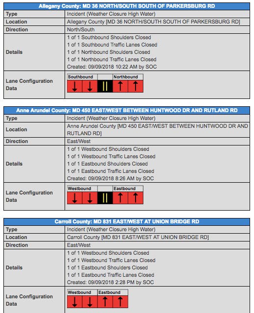
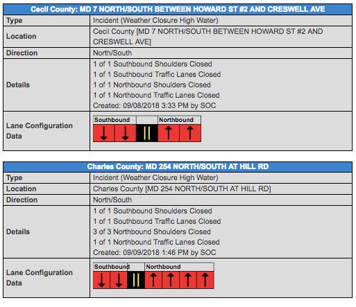
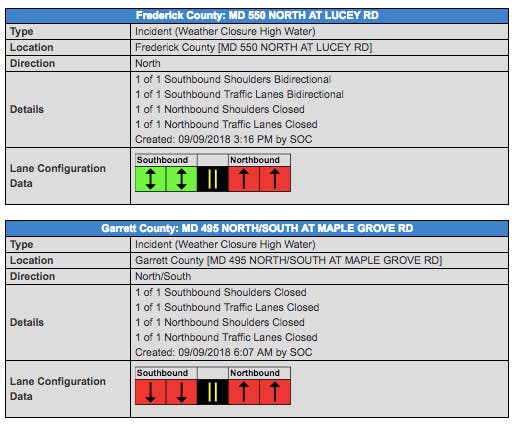
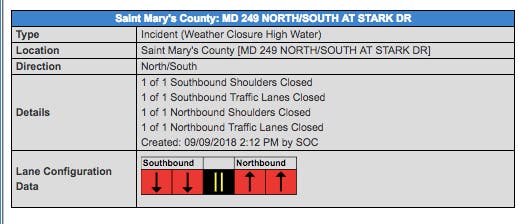
High water has resulted in road closures in Allegany, Anne Arundel, Carroll, Cecil, Charles, Frederick, Garrett and St. Mary's counties, according to state transportation officials.
See the latest lane closure information from state transportation officials.
A coastal flood advisory is in effect until noon on Monday, Sept. 10, in Baltimore City and Baltimore County.
Weather officials said the Baltimore and Baltimore City shoreline may be inundated, with tides 1.5 to 2 feet above normal. The end of Thames Street in Baltimore as well as the promenade at the dragon boat dock in Baltimore may flood, and so will the Bowleys Quarters, according to the advisory.
The next high tides will be as follows, according to the National Weather Service:
- Fort McHenry: 7:09 p.m. Sunday, 7:37 a.m. Monday
- Bowley Bar: 8:26 p.m. Sunday, 8:51 aa.m. Monday
PREVIOUS WARNING (EXPIRED): The National Weather Service issued a flood warning for much of Maryland Sunday. Up to 2 inches of rain had fallen by 9:30 a.m., the flood warning stated, and an additional 1 inch of rain is expected before the end of the warning period.
The gauge along the Patapsco River in Elkridge indicates there is high water, according to weather officials, who said high water has been reported along Hammonds Ferry Road and Furnace Avenue.
These areas are under the flood warning:
- Anne Arundel County
- Baltimore City
- Baltimore County
- Carroll County
- Frederick County
- Harford County
- Howard County
- Montgomery County
Specifically, the flood warning said these areas may experience flooding: Baltimore, Columbia, Germantown, Frederick, Bowie, Severn, Pikesville, Crofton, Middle River, Cockeysville, Westminster, Elkridge, Damascus, Aberdeen, Havre De Grace, Riviera Beach, Thurmont, Emmitsburg, Aberdeen Proving Ground and the Baltimore-Washington Airport.
Weather officials say that runoff from the recent heavy rainfall will cause flooding of small creeks and streams, urban areas, highways, streets, underpasses, drainage areas and other low-lying spots.
During a flood warning, flooding is imminent or occurring. Drivers should turn around if they come across flooded roads, and pedestrians should not attempt to walk through flood waters.
A flood watch is in effect until 6 a.m. Monday due to the moderate to heavy rain that is expected to continue throughout the day Sunday and overnight, according to the National Weather Service.
Average rainfall amounts around 2 to 4 inches are expected during the flood watch period, with locally higher amounts possible, weather officials said.
SEE ALSO: Florence To Become 'Major Hurricane' For Southeast
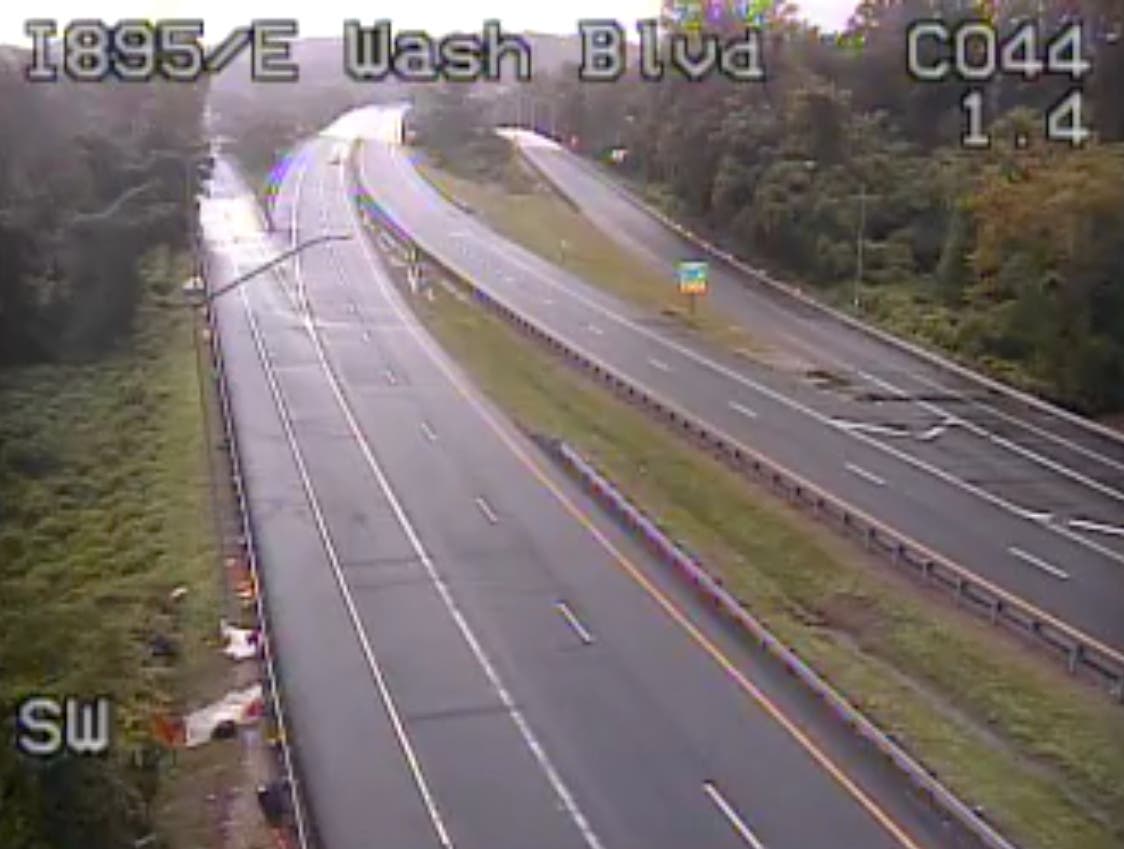
Pictured, still from CHART traffic camera at the Baltimore Harbor Tunnel/Interstate 895 as of 10 a.m. on Sunday, Sept. 9; also still from CHART traffic camera on I-70 at I-695 after 3:30 p.m. on Sunday, Sept. 9. Tables from CHART showing lanes closures. Still from I-695 at I-83 at 9:50 p.m.
Get more local news delivered straight to your inbox. Sign up for free Patch newsletters and alerts.