Weather
MD Weather: Tornado, Flood Alerts Go Up As Florence Moves Through
Weather officials have issued a tornado watch, flood advisories and other alerts as the remnants of Florence move through Maryland.


BALTIMORE, MD — Parts of Maryland are under a flash flood watch Monday as the remnants of Florence arrive. The flash flood watch calls for 1 to 2 inches of rain, with locally heavier amounts possible. Rain is expected to continue through the afternoon, with thunderstorms possible Monday night as well. The National Weather Service has issued hazardous weather outlooks around the state calling for heavy rain as well as coastal flood advisories and a tornado watch. There is a high risk of rip currents, and a small craft advisory is in effect until Wednesday.
Post-Tropical Cyclone Florence was located 200 miles west-southwest of Hagerstown as of 5 p.m. on Monday, according to the National Weather Service. Winds have weakened to about 25 mph, and Florence is on track to reach southern New England on Tuesday and move off the East Coast by Wednesday, the weather service advised. While the storm system moves on, the impact remains severe in the Carolinas. Parts of North Carolina saw more than 30 inches of rain in the past few days, leading to catastrophic flash flooding. At least 17 people have died in the storm, and hundreds have been rescued from flooded areas.
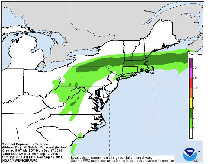
As the storm moves northeast, two tornadoes were reported in Virginia. A tornado watch was issued until 10 p.m. Monday for Anne Arundel, Calvert, Charles, Prince George's and St. Mary's counties. Much of Maryland will get 1 to 2 inches of rain from Florence by Tuesday morning, based on the forecast from the National Weather Service's Weather Prediction Center. By Wednesday, forecasters say any precipitation from Florence will have moved off the East Coast. (See the forecast below. Also see a map of watches, warnings and advisories from the National Weather Service.)
Find out what's happening in Baltimorefor free with the latest updates from Patch.
- Florence Brings Catastrophic Flooding To Carolinas
- Maryland Highway Sign: 'TRAVEL NOT ADVISED' To North Carolina
- Record Rainfall Totals Rising, As Are River Levels In Carolinas
- Florence Downgraded To Tropical Storm, Relentless Rain Continues
"Florence is expected to produce heavy and excessive rainfall over the next couple of days," the National Weather Service's Weather Prediction Center said in a statement at 5 a.m. on Monday. "Portions of the Mid-Atlantic states west of Interstate 95 into southern New York and southern New England are expected to receive an additional 2 to 4 inches of rain...with isolated maximum amounts of 6 inches possible."
Find out what's happening in Baltimorefor free with the latest updates from Patch.
Weather Alerts Issued In MD
A tornado watch is in effect for Anne Arundel, Calvert, Charles, Prince George's and St. Mary's counties until 10 p.m. Monday. A tornado warning is in effect in Charles County, according to the Maryland Emergency Management Agency.
The U.S. National Weather Service (NWS) has issued a TORNADO WARNING for @Charles County, MD
WHAT IS a Tornado Warning:
Take Action! A tornado has been sighted or indicated by weather radar.
There is imminent danger to life and property. Move to an interior room/lowest level pic.twitter.com/JCu82I6odv
— Maryland Emergency Management Agency (MDMEMA) (@MDMEMA) September 17, 2018
A coastal flood warning is in effect from 9 p.m. Monday to 6 a.m. Tuesday for the shoreline in Anne Arundel County. High tides should be 1.5 to 2 feet above normal. High tide at Annapolis is at 1:09 a.m. Tuesday.
A coastal flood advisory has been issued for Baltimore City and Baltimore County. The advisory is in effect from 10 p.m. Monday to 7 a.m. Tuesday and calls for flooding in several areas around high tide.
Part of Harford County is under a coastal flood advisory from 1 to 9 a.m. Tuesday, calling for flooding in Havre de Grace around high tide. Tides are expected to be 1.5 to 2 feet above normal.
A coastal flood advisory is in effect until 1 a.m. Tuesday for the shoreline in St. Mary's County, where tides are expected to come in 1.5 feet above normal. High tide at Point Lookout is at 8:54 p.m., Piney Point is at 9:35 p.m. and Coltons Point is at 10:11 p.m. Water is expected to go over a portion of the bulkhead near the Straits Point bridge and cover yards in the St. George Creek and St Mary's River areas. Minor shoreline inundation up to 1 foot above ground is possible elsewhere. A coastal flood advisory means that winds and tides will combine to create flooding on low-lying areas along the shore, tidal rivers and creeks.
There is a flash flood watch until 4 a.m. Tuesday.for Anne Arundel, Baltimore, Carroll, Charles, Frederick, Harford, Howard, Montgomery, Prince George's and Washington counties as well as Baltimore City, the District of Columbia and parts of Virginia. Moderate to locally heavy rain will spread over these areas Monday, expected to total 1 to 2 inches, with locally higher amounts possible. While the steadiest rain may move out of the area by late Monday afternoon, additional showers and isolated thunderstorms are likely in the evening.
A hazardous weather outlook has been issued for Anne Arundel, Calvert, Charles, Prince George's and St. Mary's counties, where heavy rain is possible as the remnants of Florence weaken and turn northeast. Severe thunderstorms as well as an isolated tornado are possible Monday afternoon and evening.
There is a hazardous weather outlook for Caroline, Cecil, Kent, Queen Anne's and Talbot counties calling for heavy rain Monday afternoon and evening that could lead to localized flash flooding. Heavy rain and flash flooding are possible in those areas Tuesday as well.
Significant Flood Outlook product has been issued for the Mid-Atlantic US https://t.co/z4PrakVyfD pic.twitter.com/HJANRIFOfw
— NWS MARFC (@NWSMARFC) September 17, 2018
At Maryland beaches, there is a high risk of rip currents until 8 p.m. Monday, so people are advised to be cautious near water, as the conditions are life-threatening. As the remnants of Florence cross west and north of the beaches through Monday night, scattered showers may produce heavy downpours. Moderate to heavy rainfall is possible Tuesday.
A small craft advisory is in effect until 2 a.m. Wednesday for the Chesapeake Bay as well as the Potomac, Patuxent and Choptank rivers and Tangier Sound. Winds of 18 to 33 knots are imminent or occurring, making conditions dangerous for smaller vessels.
The river is running high and is full of hazards. pic.twitter.com/xieK2V7u1i
— Susquehanna SP (@SusquehannaSP) September 12, 2018
(Stay on top of all the latest Florence news with our free, real-time news alerts, find your local Patch here. If you have an iPhone, click here to get the free Patch iPhone app; download the free Patch Android app here. And like Patch on Facebook!)
River Flood Watches have also been issued for several rivers, including portions of the Cacapon, Opequon, Conococheague, Shenandoah, South, and Potomac. pic.twitter.com/58Z1MJ8LvA
— NWS DC/Baltimore (@NWS_BaltWash) September 17, 2018
Weather Forecast For The Week
Here's the detailed forecast from the National Weather Service:
Monday: Showers, with thunderstorms possible after 2 p.m. Chance of rain: 70 percent. The most rain from Florence will likely hit west of the Appalachians, according to forecasters. Showers that hit the Baltimore-Washington area will likely include heavy rainfall because of high levels of moisture. There will be breaks in precipitation. High near 79 and low of 72. Southeast winds of 7 to 14 mph, with gusts up to 21 mph.
A Flash Flood Watch is in effect through tonight for areas in green. Moderate to locally heavy rain will overspread the area this AM. Steadiest rain may leave this afternoon, but additional showers & isolated thunderstorms are likely this evening. Locally heavy rain possible. pic.twitter.com/y23X80066w
— NWS DC/Baltimore (@NWS_BaltWash) September 17, 2018
Tuesday: Showers likely and thunderstorms possible. Chance of rain: 70 percent. High of 81 and low of 67 degrees. Southwest wind around 9 mph.

Wednesday: Sunny, with a high near 81 and low of 63 degrees.
Thursday: Sunny, with a high near 78 and low of 66 degrees.
How Maryland Is Helping With Florence Relief
Several crews from Maryland have deployed to assist with relief efforts in the Carolinas.
Gov. Larry Hogan authorized a helicopter rescue team — made up of Maryland Army National Guard members and helicopter search and rescue technicians from Baltimore, Harford, Howard, and Montgomery counties — to help with search and rescue efforts in North Carolina. Two UH-60 Blackhawk helicopters with eight crew members and three maintainers left Sunday to assist with the recovery effort.
On Wednesday morning, the Montgomery County Fire and Rescue Service's Maryland Task Force One Urban Search and Rescue Team left Rockville for its deployment by the Federal Emergency Management Agency to Columbia, South Carolina, in advance of what was then Hurricane Florence.
Maryland also opened two shelters, one in Prince George's County and another in Talbot County, for those seeking relief.
- MD Helicopter Rescue Team Heading To NC In Hurricane Relief
- Howard County Rescuers Head For Carolinas
- UMD Ritchie Coliseum To Be Used As Shelter For Hurricane Victims
The Jarrettsville Vet Center helped rescue animals from North Carolina shelters along with the Animal Rescue Inc. and Black Dogs & Company Rescue.
Images courtesy of the National Hurricane Center/NOAA.
Get more local news delivered straight to your inbox. Sign up for free Patch newsletters and alerts.