Weather
Hurricane Florence Steering Away From MD, Light Rain Expected
Hurricane Florence may only bring an inch of rain to MD. Officials urge residents to remain vigilant, the storm's path could change again.

ANNAPOLIS, MD — Hurricane Florence may only bring an inch or two of rain to Maryland, but state emergency officials tell residents they must remain vigilant and prepare for a bigger impact because the huge storm's path could change again. Last night the storm shifted its course a bit to the south, prompting some authorities to say Maryland has dodged a bullet. The Category 3 storm has winds of 120 miles per hour, and its strength is expected to fluctuate through Thursday morning as it makes its way to land. "Although slow weakening is expected to begin by late Thursday, Florence is still forecast to be an extremely dangerous major hurricane when it nears the U.S. coast late Thursday and Friday," the National Hurricane Center said Wednesday evening.
Updated forecasts seem to have cut the expected rainfall for Maryland from the storm. "Yes. The latest NWS update DOES show Florence potentially steering away from Maryland, but flooding is still a concern and we need to remain prepared," the Maryland Emergency Management Agency said on Facebook.
But we're not out of the woods just yet. While the newest computer models show Florence heading south toward South Carolina and possibly even Georgia once it makes land, it could then head north again and bring to the Mid-Atlantic region next week, The Washington Post's Capital Weather Gang says.
Find out what's happening in Owings Mills-Reisterstownfor free with the latest updates from Patch.
The Anne Arundel County Emergency Management Office said on social media Wednesday that Marylanders will miss the worst of the storm initially. "This doesn't mean we should let our guard down though! The weekend may bring tidal flooding and continued rainfall. Preparing for storms is a crucial element of keeping your family safe during emergencies," the office said.
"We do not expect significant rain, more than showers, or strong winds through Sunday, because the storm is tracking so far south of us," The Washington Post said. "But next week, the storm may return north and deliver an uncertain amount of rain between Monday and Wednesday."
Find out what's happening in Owings Mills-Reisterstownfor free with the latest updates from Patch.
That's not a good scenario for a waterlogged state. Maryland officials are most concerned about flooding if remnants of the storm stall over the region. Free sand for sandbags were offered to Harford County residents at sites in Joppa and Edgewood on Tuesday, and in Annapolis and Ellicott City on Wednesday. “As we move closer to the event and the inland track of Florence becomes clearer, so will the rainfall totals and resultant flooding impacts across our area,” the National Weather Service said in forecast discussions. “Thursday night through Friday night has the potential to be unsettled as Florence remains to our south, though the extent of which is a bit in question." Higher totals are more likely south of the Washington, D.C., metro, the NWS said.
(Stay on top of all the latest Hurricane Florence news with our free, real-time news alerts, find your local Patch here. If you have an iPhone, click here to get the free Patch iPhone app; download the free Patch Android app here. And like Patch on Facebook!)
President Trump has approved emergency disaster declarations for the Carolinas as well as Virginia. “All interests from South Carolina into the Mid-Atlantic region should ensure they have their hurricane plan in place and follow any advice given by local officials,” the Hurricane Center said as residents wait to see where the storm drops the heaviest rain.
This region will be particularly susceptible to flooding because of far-above-normal rainfall in the region since May. In addition, because the ground is likely to be saturated, trees would be vulnerable in strong winds.
Hurricane Florence will make landfall on the coast near the border of North Carolina and South Carolina early Friday morning, then stall over the region, according to forecasters from the National Weather Service serving the Baltimore-Washington area. "Currently the strongest winds associated with Florence are expected to stay off to the south of our area," the weather service said in its Tuesday afternoon forecast discussion. Because of saturated soil, weather experts said downed trees are still a possibility with slightly windy conditions in Maryland.
"For our area, the primary threat from Florence will be the potential for a prolonged period of heavy rainfall across the region," the National Weather Service reported. It was too early to pinpoint which areas would have the greatest threat, experts said Tuesday, noting that coastal flooding along the Chesapeake Bay and tidal Potomac would continue to be a concern.
Hurricane watches and storm surge watches went up Tuesday for the Carolinas to the Virginia border, with tropical storm-strength winds and rising water expected in the next 48 hours. "Florence is expected to be an extremely dangerous major hurricane through Thursday night," the National Hurricane Center said Tuesday morning. Forecasts call for torrential rains, tropical storm force winds, and tidal flooding/storm surge to affect the state beginning as early as Thursday, the governor's office said, while landfall in the Carolinas is expected at 2 a.m. Friday. It's still too early to know how close the storm will come to Maryland and what the impact will be on the state, but Annapolis has had coastal flooding close some downtown streets for several days.
Maximum sustained winds are near 130 mph with higher gusts. "Florence is expected to begin re-strengthening later today and continue a slow strengthening trend for the next day or so," NHC forecasters said Tuesday. "While some weakening is expected on Thursday, Florence is expected to be an extremely dangerous major hurricane through landfall."
"The threat is increasing for potentially extreme and life-threatening flooding and other impacts for our region as Florence approaches later this week and through the weekend. Now is the time to prepare," the National Weather Service for Baltimore/Washington said. Officials urged residents to check the evacuation zone maps drawn by the Maryland Emergency Management Agency so they know if their area is included in any orders.
The cities of Baltimore, Annapolis, and Ocean City, along with Anne Arundel, Baltimore, Caroline, Calvert, Cecil, Charles, Dorchester, Harford, Kent, Prince George's, Queen Anne's, Somerset, St. Mary's, Talbot, Wicomico and Worcester counties, are part of the zones. Check addresses and find more information at KnowYourZoneMd.com.
Cautionary note to everyone in Mid-Atlantic & SE: The forecast for #Florence is straight forward thru Fri- it's coming toward SC/NC coast & is going to be bad. But then wild uncertainty in path which has big implications for impacts W, SW, and N of eastern Carolinas. Stay tuned. pic.twitter.com/KTaT70OqUf
— Capital Weather Gang (@capitalweather) September 11, 2018
At 8 a.m. Wednesday, the center of Hurricane Florence was moving toward the west-northwest at 17 mph, the NHC says. The center of Florence will move over Bermuda and the Bahamas through Wednesday, and approach the coast of North Carolina or South Carolina in the hurricane warning area on Thursday and Friday.
Storm surge warnings and hurricane warnings have now been posted for portions of North and South Carolina. A tropical storm warning has been issued from north of Duck, North Carolina, to the North Carolina/Virginia border and a tropical storm watch is in effect from north of the North Carolina/Virginia border to Cape Charles Light, Virginia, along with the Chesapeake Bay south of New Point Comfort.
Crews from the Maryland Department of Transportation State Highway Administration are out now to inspect, clean and clear storm water ditches, drains and inlets to let rainwater drain. “This is a major storm system, and it will likely cause significant damage and disruption to the state highway system,” said MDOT SHA Administrator Gregory Slater in a news release. “Maryland has received above-normal rainfall throughout summer and the ground is saturated so additional rain is likely to run-off rapidly.”
Officials in North Carolina, South Carolina and Virginia have already declared states of emergency to give residents ample time to prepare. Washington, D.C., officials declared an emergency Tuesday morning as the District prepares for heavy rains and flooding. Virginia Gov. Ralph Northam ordered a mandatory evacuation for Zone A, including the Eastern Shore and Hampton Roads areas starting Tuesday. WTOP says about 245,000 people live in the coastal area.
National Hurricane Center Director Ken Graham said in a Monday briefing that the impacts of Florence will be felt far outside the cone from rainfall and strong winds. He said the storm will almost “park” over North Carolina. “That spells problems because the longer it waits, the more that it sits the more rain we have,” he said, adding that water kills 90 percent of people in tropical systems.
Saturated soil, high winds, and downed trees and power lines are going to be a major issue. "Additionally there are going to be problems with dangerous, life-threatening storm surge all the way up through the Virginia coast," he said, and possibly Maryland.
"We continue to monitor Hurricane Florence as it moves toward the coast. Please, take this time to prepare yourself, your family, and your home," Hogan said Monday. (See safety and preparedness tips below that you should do before the storm gets closer to the US coast.) Officials said a rumor spread on social media falsely said Crisfield, Maryland, was under evacuation orders.
Storm preparations should include having a storm kit, evacuation plan, and proper insurance coverage, which includes flood insurance, says AAA Mid-Atlantic. “Along with your hurricane supply kit, officials recommend that families ensure they have emergency plans in place and that they communicate and practice them with family members and friends. According to FEMA officials, 60 percent of Americans do not practice what to do in the event of a natural disaster.”
If it seems like hurricane season has been getting worse and worse, it’s because it has, says AAA. In 2017, there were 17 named storms – ten of which were hurricanes, with sustained winds of at least 74 mph – and together they caused a record $316 billion in damage. Last year was also the first time in which the United States endured two storms that were Category 4 or stronger in the same year.
SEE ALSO:
- MD Governor Declares State Of Emergency For Hurricane Florence
- Hurricane Florence: Protect Your Pet In A Storm
- Hurricane Florence: Preparedness Kit To Pack, Insurance Info
Supplies are flying off the shelves at stores in Maryland and other areas likely to be pummeled by the storm. Weather officials said the storm became a major hurricane around 11 a.m. Monday. It will remain an "extremely dangerous" hurricane through Thursday. Tropical-storm-force winds will reach the coast of the Carolinas possibly by Wednesday night, but the most likely time is Thursday morning, forecasters said.
"As Florence approaches the southeastern United States, there will likely be fluctuations in intensity from eyewall cycles, but even if this occurs, the hurricane’s wind field is expected to grow with time, increasing the storm surge and inland wind threats,” the National Hurricane Center said.
There is an "increasing risk" that the powerful storm could bring life-threatening effects to the Mid-Atlantic region, the hurricane center said. This includes coastal storm surge and flooding from prolonged heavy rainfall. Federal officials said Tuesday that downpours could wreak havoc in western and central Virginia and maybe beyond as the storm system slowly moves across land.
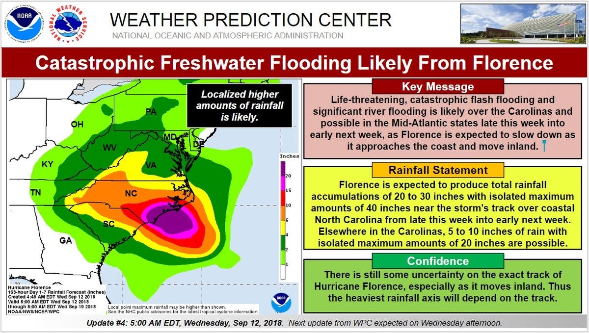
"There’s some indication the hurricane will slow or stall out over the Mid-Atlantic later this week, which could lead to a disastrous amount of rain," The Washington Post's Capital Weather Gang writes. Florence could slow and dump more than two feet of rain could fall over the higher elevations of the Carolinas and Virginia, which would generate dangerous flooding downstream, the newspaper says.
Tropical storm force winds could arrive as early as Wednesday evening. CNN reported that this would be the first Category 4 storm to strike the East Coast since 2004, when Jeanne smashed into Florida. Many computer models show the storm will become a slow, plodding storm that will dump rain over the coast similar in effect to the devastating Hurricane Harvey.
The latest track from the National Hurricane Center brings Florence onto land by Friday morning, and remnants of the storm over Virginia on Saturday, according to the National Weather Service. At that point, there is still uncertainty with the eventual track of Florence.
SEE ALSO: Hurricane Season 2018: Fewer Storms Forecast
Florence is the first storm above category 3 to form this season and has formed as the Atlantic hurricane season reaches its peak.
Power Outage Tips
- Use flashlights during outages instead of burning candles. Keep plenty of fresh batteries on hand at all times.
- If using candles, make sure they are placed on a stable piece of furniture in sturdy holders that will not tip over. Candles should fit in the holders securely and the holders should be made of material that will not burn.
- Keep candles away from anything combustible, such as clothing, books, papers, curtains, decorations or anything else that can burn.
- Do not place candles where they can be knocked over by children or pets. Always extinguish all candles when leaving the room or before going to sleep.
- Never use candles, matches or lighters if medical oxygen therapy is used in the home.
- Charged solar landscape lighting can be brought indoors for temporary lighting as a safe and effective alternative to candles.
- Ensure burners on stoves are in the off position during a power outage and remove any items from the stove-top to prevent unattended heating when the power is turned back on.
- Install and maintain CO alarms inside your home to provide an early warning of carbon monoxide exposure.
- If you use portable generators for electricity during power outages, use extreme caution when refueling. Fuel splashed on a hot muffler could ignite, causing severe burns and serious injuries.
- Never attempt to refuel a generator while it is running. Always allow the unit to cool before attempting to refuel.
- Operate generators outside of the home and outside of garages. Carbon monoxide gas produced by operating generators is poisonous and can quickly cause severe injury or death.
Hurricane Preparation Tips
- Get Prepared: Take action now to be prepared for hurricane season. As the storm approaches, it is often too late to get ready. Make sure you have family evacuation and communications plans, update your emergency supply kit, and evaluate your flood insurance needs.
- Complete a family communication plan. Plan how you will assemble your family and loved ones and anticipate where you will go for different situations. Get together with your family and agree on the ways to contact one another in an emergency and identify meeting locations.
- Create or restock your emergency kit. Being prepared means having your own food, water and other supplies to last for at least 72 hours. A disaster supplies kit is a collection of basic items your household may need in the event of an emergency, including an all weather radio.
- Check your insurance coverage. Most homeowner's insurance policies do not cover damage or losses from flooding. Review your policy, ensure you're adequately covered and understand exclusions, and contact your agent for any changes.
- Stay Informed. Know where to go for trusted sources of information during a hurricane event. Monitor local news resources for hurricane watches and warnings and follow directions of local officials.
- Determine Your Risk. Find out what types of wind and water hazards are likely in your area. Hurricanes are not just a coastal problem and their effects can reach hundreds of miles inland. Since the U.S. has not been hit by a major hurricane (category 3 or higher) in over a decade, "many people are suffering from hurricane amnesia in the forms of complacency, denial and inexperience."
- Develop an Evacuation Plan. Find out if you live in a storm surge hurricane evacuation zone or if your home is unfit to keep you safe in a hurricane. Speak with family and friends and work out a plan to use their home as an evacuation destination. Be sure to account for pets, since many shelters do not allow them.
- Assemble Disaster Supplies. Supplies are necessary not just for the storm itself, but for the often long and grueling aftermath. Stock up on non-perishable food, water and medicine to support your family for at least a week. Other recommended items are cash and battery-powered radios and flashlights. Since many of us use cell phones, have a solar-powered or hand-crank USB charger.
- Keeping Food Cold. Stock a cooler with ice. Keep what cold air you have inside the freezer – do not open the door any more than necessary. A full freezer should stay at freezing temperatures about two days; a half-full freezer about one day. If your freezer is not full, group packages so they form an "igloo" to protect each other.
- Know Your Risk and Plan Ahead for an Evacuation:
- Know how to receive information including recommendations or orders to evacuate.
- If you plan to go to a shelter, notify staff of any special needs you or your family have.
- Do not return to the evacuation area until the evacuation order is lifted.
Get Tech Ready
Technology has made it easier to prepare for emergencies, but it can be unreliable during big storms if you haven't planned to keep your gadgets protected and powered up. Here are some tips to make sure you are tech ready:
Be Informed
Here are basic commands to get started:
- Download the FEMA app. Receive weather alerts from the National Weather Service for up to five different locations anywhere in the United States. To search for open shelters (for disaster survivors): text SHELTER and to 43362 (4FEMA).
Make A Social Media Plan
- Use text messages, social media and email to connect with friends and family during emergencies.
- Mobile networks can become overwhelmed during emergencies, making it difficult to place and receive phone calls. Text messages require less bandwidth, which means they are able to be transmitted more reliably.
- Social media channels such as Facebook and Twitter can also be an effective way to update family and friends during emergencies. Facebook's Safety Check feature allows users to easily post a status update indicating that they are safe during a time of disaster.
- Register with American Red Cross's Safe & Well site to let family and friends know you're okay.
- Have an emergency charging option for your phone and other mobile devices. Smartphones have become a vital tool to receive emergency alerts and warnings,, so it's important to make sure you can keep them powered up in an emergency.
- At home: Before severe weather, charge all of your electronic devices. If the power goes out, preserve battery power by minimizing device use. Keep a back-up power source on hand to recharge your phone so that you can stay connected even during an extended power outage.
- In your car: Keep a portable phone charger in your vehicle at all times, and consider purchasing a back-up power supply to keep in your vehicle as well.
- Change the settings on your phone to low power mode or place it on airplane mode to conserve energy.
- Store important documents in a secure, password-protected jump drive or in the cloud.
- Capture electronic versions of important documents such as insurance policies, identification documents, and medical records. Don't forget to include your pet's information.
- Back-up your computer to protect photos and other personally important electronic documents.
- Scan old photos to protect them from loss.
- Keep your contacts updated and synced across all of your channels, including phone, email and social media. This will make it easy to reach out to the right people quickly to get information and supply updates. Consider creating a group listserv of your top contacts.
- Create a group chat via a texting app or a thread for family/friends/coworkers to communicate quickly during a disaster.
Sign up for Direct Deposit and electronic banking through your financial institution so you can access your payroll funds and make electronic payments wherever you are. Federal benefit recipients can sign up by calling (800) 333-1795 or at GoDirect.org.
Residents readying for a storm can get tips and advice on the federal government's Ready.gov website. To keep up with potential storms during hurricane season, bookmark the National Hurricane Center's website.
For local weather and severe weather alerts, visit the National Weather Service online.
— Includes reporting by Patch Editors Elizabeth Janney and Dan Hampton.
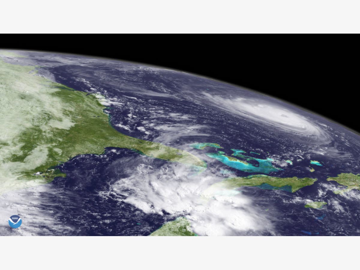
PHOTO: Satellite image provided by National Oceanic and Atmospheric Administration (NOAA), Hurricane Florence churns through the Atlantic Ocean toward the U.S. East Coast on September 11, 2018. (Photo by NOAA via Getty Images) Graphics by National Weather Service
Get more local news delivered straight to your inbox. Sign up for free Patch newsletters and alerts.