Traffic & Transit
Dangerous Crossroads Headed For Reroute: Here’s A Look
For years, the state has wanted to reconfigure an intersection bordering Woburn and Burlington. Now there are details about the project.

WOBURN AND BURLINGTON, MA — Drivers in these two communities have waited over a decade for a safer crossroads, and now there are details about what it might look like – as well as the dollars and land it might cost.
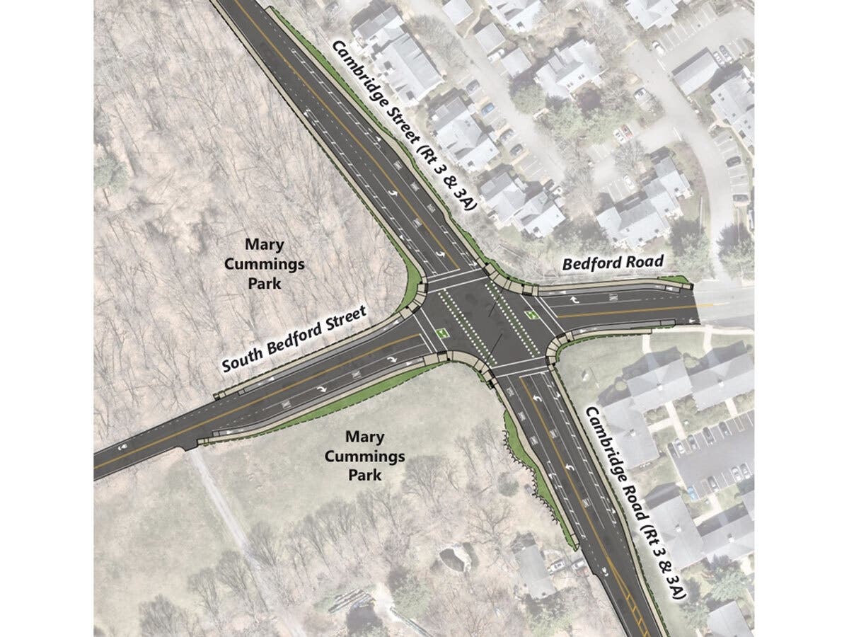
The juncture of MA Route 3 and Bedford Road has long been a danger zone.
Straddling the border between Woburn and Burlington, the intersection gets heavy traffic. Interstate 95/Route 128 is just a half-mile north, along with offices and shopping malls. But the side streets here are residential and a 216-acre green space, Mary Cummings Park, is next door.
Find out what's happening in Woburnfor free with the latest updates from Patch.
In 2014 the state recognized the intersection was a problem; in 2021 it ranked within the top 5% of all Massachusetts “crash clusters.” Sixty accidents took place here from 2017 to 2021, according to the Department of Transportation.
The DOT planned to reconfigure the intersection, and shovels were due in the ground this spring. But work has been delayed because the proposed design would encroach on the park.
Find out what's happening in Woburnfor free with the latest updates from Patch.
On Wednesday, the state published a report describing how it plans to take some of that public space and what the community might get in return.
Land loss, and gain
To widen the roadways and make room for new turning lanes, bike lanes and sidewalks, the DOT says it needs to acquire a half-acre of land, either by purchasing it or obtaining easements.
Roughly a quarter-acre would come from the eastern edge of the park and be paved over. Trees would be uprooted – and the report notes that "the right-of-way is not large enough to accommodate replacement trees."
Woodlands, wetlands and fields fill the park, created in 1930 from the estate of philanthropist Mary Cummings "to be forever open as a public pleasure ground."
Boston suburbs are loath to lose even a little green space. But giving up this ground might be a bargain. That's because the town of Burlington has obtained nine acres of land to offset the loss.
The so-called "replacement land" is about a mile away, off Wheeler Road, and like the park is wild and undeveloped. Burlington got the parcel when the landowner, Wheeler Self Storage, agreed to a conservation restriction. The DOT and its consultants estimate the property's value is $1.7 million – 13 times that of the parkland being paved.
If the land swap and other components of the project receive necessary approvals, construction will start in early 2027 and take about two years, according to the state report. The cost is now estimated to be $6.3 million.
See Also:
Get more local news delivered straight to your inbox. Sign up for free Patch newsletters and alerts.