Weather
Arctic Blast To Sweep Across MN With Dangerously Cold Temps
Temperatures will take a nosedive Wednesday afternoon.

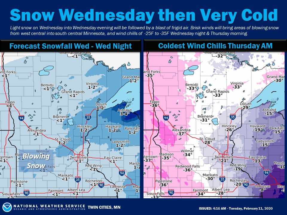
TWIN CITIES, MN — An Arctic blast will bring dangerously cold temperatures across Minnesota Wednesday afternoon. Be prepared for brisk winds, and blowing snow, and wind chills that will drop down to 35 degrees below zero overnight.
"An Arctic front will blast across the area Wednesday afternoon," says the National Weather Service.
"Expect light snow, brisk winds, and blowing snow. In the wake of the front, very cold wind chills are expected Wednesday and Thursday nights."
Find out what's happening in Southwest Minneapolisfor free with the latest updates from Patch.
Here's the NWS forecast for the Twin Cities metro area:
Tuesday: Mostly sunny, with a high near 27. Southwest wind around 10 mph.
Tuesday Night: Partly cloudy, with a low around 22. South wind around 10 mph.
Find out what's happening in Southwest Minneapolisfor free with the latest updates from Patch.
Wednesday: Snow, mainly after 3 p.m. Patchy blowing snow after 4 p.m. Temperature rising to near 31 by noon, then falling to around 21 during the remainder of the day. Blustery, with a west southwest wind 10 to 15 mph becoming north 15 to 20 mph in the afternoon. Winds could gust as high as 25 mph. Chance of precipitation is 80 percent. New snow accumulation of less than one inch possible.
Wednesday Night: A 30 percent chance of snow before midnight. Patchy blowing snow between 10 p.m. and midnight. Mostly cloudy, with a low around -7. Wind chill values as low as -22. Blustery, with a north wind 10 to 20 mph, with gusts as high as 30 mph.
Thursday: Mostly sunny and cold, with a high near 2. North northwest wind 5 to 10 mph.
Thursday Night: Mostly clear, with a low around -12. West northwest wind around 5 mph becoming calm in the evening.
Friday: Mostly sunny, with a high near 15. Light south wind becoming south southeast 10 to 15 mph in the morning.
Friday Night: A 30 percent chance of snow after midnight. Mostly cloudy, with a temperature rising to around 20 by 5am. South wind 10 to 15 mph.
Saturday: A 40 percent chance of snow. Mostly cloudy, with a high near 32. South wind 5 to 10 mph becoming west northwest in the afternoon.
Saturday Night: A 20 percent chance of snow before midnight. Mostly cloudy, with a low around 18. West wind around 5 mph becoming calm in the evening.
Sunday: Mostly cloudy, with a high near 34. Calm wind becoming south around 5 mph in the afternoon.
Sunday Night: A 30 percent chance of snow. Mostly cloudy, with a low around 26. South wind around 5 mph becoming west southwest after midnight.
Monday: A 20 percent chance of snow. Mostly cloudy, with a high near 35. West wind around 5 mph.
Get more local news delivered straight to your inbox. Sign up for free Patch newsletters and alerts.