Weather
Heavy Snow And Ice To Return To New Hampshire Wednesday: Forecasters
National Weather Service issues "storm watch"; up to 18 inches of snow possible; at least 4 to 8 inches expected; 62K still without power.


GRAY, ME — New Hampshire has been placed on another winter storm watch as the state continues to clean up from the late weekend storm and tens of thousands of Granite Staters still remain without power.
The National Weather Service issued the watch and a hazardous weather outlook Tuesday, warning of at least 6 inches of snow in most parts of the state, possibly more, on Wednesday and Thursday.
“Low pressure brings a round of moderate to heavy snow late Wednesday afternoon and evening,” the alert stated. “Snow changes to mixed precipitation Wednesday night from south to north, with light ice accretion possible across interior areas. The precipitation likely ends as rain along the coastline Thursday morning, with snow or mix possible into the afternoon hours across northern areas.”
Find out what's happening in Concordfor free with the latest updates from Patch.
Forecasters said roadways would be “slick and hazardous,” with as much as 1 to 2 inches of snow falling per hour on Wednesday night.
“Periods of moderate and heavy snow will combine with low visibility to create dangerous driving conditions,” the alert stated. “Ice may accumulate and cause slippery conditions on untreated surfaces. The hazardous conditions could impact the Wednesday evening and Thursday morning commutes.”
Find out what's happening in Concordfor free with the latest updates from Patch.
Wind gusts of up to 35 mph, too, were expected.
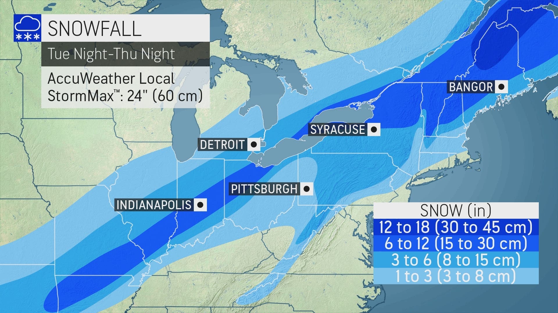
Possible snow accumulations for the upcoming storm. Credit: AccuWeather.com.
AccuWeather.com warned this storm would pack a bigger punch than the Sunday to Monday storm that delivered more than a foot of snow in Concord. Forecasters there said the StormMax amount could be as much as 24 inches.
According to the NWS, the Concord Airport reported 14 inches of snow, while Sunapee reported 17 inches of snow, the most in the state.
The timeline of the warning was 1 p.m. on Wednesday through 1 p.m. on Thursday. Concord and the capital region can expect snow to start sometime after 3 p.m. on Wednesday. In Nashua, eastern and western Hillsborough County, and inland Rockingham County, the storm will start around 4 p.m. On the Seacoast, the storm was expected to start around 5 p.m.
Around New Hampshire, power companies are still reporting about 62,000 customers without power.
About 2,400 customers in Amherst are without power, while 2,300 in Merrimack are out. Bedford has around 2,100 without power. Milford has around 900 customers without power. More than 300 are without power in Exeter.
New Hampshire Department of Safety’s Division of Homeland Security and Emergency Management also warned residents to use caution when cleaning up from the storm.
“During storm cleanup, wear protective clothing and be cautious to avoid injury,” HSEM Director Robert Buxton said. “Downed power lines and debris can pose a danger.”
The latest weather conditions can be found on the front page of every Patch.com site in the United States, including the 14 New Hampshire Patch news and community websites covering Amherst, Bedford, Concord, Exeter, Hampton, Londonderry, Manchester, Merrimack, Milford, Nashua, North Hampton, Portsmouth, Salem, Windham, and Across NH. Local weather reports for New Hampshire are posted on Sundays and Thursdays. Alerts are published when needed.
Got a news tip? Could you send it to tony.schinella@patch.com? View videos on Tony Schinella's YouTube.com channel or Rumble.com channel.
Get more local news delivered straight to your inbox. Sign up for free Patch newsletters and alerts.