Weather
Strong Afternoon T-Storms, Isolated Tornado Possible For New Hampshire
Update: Forecasters warn of storms throughout the state — wind gusts, hail are possible; high temperatures to continue during the weekend.

GRAY, ME — The National Weather Service issued several alerts on Thursday warning of storms, a heat advisory, and then sunny and hot weather during the weekend.
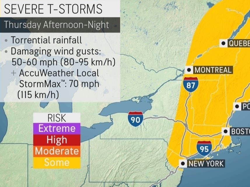
In a special weather statement around 10:30 a.m., forecasters said “scattered strong to severe” thunderstorms were expected from 1 to 8 p.m. on Thursday as a cold front moves into the region.
“Some may become locally severe and produce damaging wind gusts, hail, and briefly heavy rainfall,” the alert stated. “While the threat is low, a brief isolated tornado cannot be ruled out.”
Find out what's happening in Concordfor free with the latest updates from Patch.
Also Read
A tornado warning was issued for both Grafton and Merrimack counties. Weather watchers also reported a possible tornado near Interstate 89 in Grantham at just before 2 p.m.
The storms were expected to develop along the Connecticut River Valley of western New Hampshire “as soon as noon” before moving east-northeast into western Maine through this afternoon and early evening.
Find out what's happening in Concordfor free with the latest updates from Patch.
“The thunderstorms are expected to gradually diminish in intensity as they approach the coast due to a marine influence,” the alert said, noting the “greatest risk for strong to severe thunderstorms” was between 1 and 8 p.m.
A heat advisory for the entire state is in place through 8 p.m., too, forecasters said.
AccuWeather.com forecasters said about 160 million Americans would deal with temperatures as high as 100 degrees during the weekend.
AccuWeather’s timeline warns of t-storms on Thursday is around 3:45 p.m. in Concord and the capital region, with a 25 to 50 percent chance of rain for the rest of the day and evening. Nashua, Hillsborough County, and interior Rockingham County will see the highest storm threat between 5 and 7 p.m. Seacoast communities can also expect t-storms around 5 p.m., forecasters said.
The NWS warned hot temps would stay in the upper 90s to low 100s this weekend.
The latest weather conditions can be found on the front page of every Patch.com site in the United States, including the 14 New Hampshire Patch news and community websites covering Amherst, Bedford, Concord, Exeter, Hampton, Londonderry, Manchester, Merrimack, Milford, Nashua, North Hampton, Portsmouth, Salem, Windham, and Across NH. Local weather reports for New Hampshire are posted on Sundays and Thursdays. Alerts are published when needed.
Got a news tip? Send it to tony.schinella@patch.com. View videos on Tony Schinella's YouTube.com channel or Rumble.com channel.
Get more local news delivered straight to your inbox. Sign up for free Patch newsletters and alerts.