Weather
More Heavy Rain On The Way For New Jersey
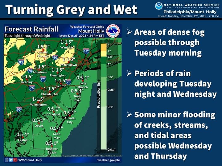
Minor creek and stream flooding is possible across New Jersey as rain adds to already saturated areas.

NEW JERSEY — If you are planning to go out and hit the post-Christmas sales, bring an umbrella or wear a raincoat: heavy rain is headed to New Jersey.
Forecasters with the National Weather Service say the state is in for wet weather for the rest of the week, but the heaviest rain is anticipated to arrive late Tuesday into Wednesday.
The forecast from the Mount Holly office says the cloudy skies will persist all day Tuesday, with rain moving in overnight, starting about 4 a.m. Wednesday. Temperatures will remain mild, with highs in the low 50s Tuesday and Wednesday, dropping into the low 40s at night. Winds are expected to be mild, at 5 mph.
Find out what's happening in Across New Jerseyfor free with the latest updates from Patch.
The rain is anticipated to begin in earnest after 7 a.m. Wednesday and continue into early Thursday, with rainfall totals of 1 to 1.5 inches possible across the state. Up to 2 inches is possible for parts of Warren County, the forecasters said.
The rain could lead to minor flooding Wednesday into Thursday, with areas that flood easily vulnerable, though that will ease as the rain tapers off.
Find out what's happening in Across New Jerseyfor free with the latest updates from Patch.
Showers remain possible throughout the day Thursday and Friday, according to the forecast, with the sun finally showing up in time for New Year's Eve.
Temperatures will remain in the low 50s through Friday and lows in the low 40s, making fog possible overnight Wednesday and Thursday.
Get more local news delivered straight to your inbox. Sign up for free Patch newsletters and alerts.