Weather
More Rain, Wintry Mix, Possible Weekend Snow In NJ Forecast
Following Tuesday's tornado, it seems New Jerseyans can expect any weather this winter besides significant snowfall.


NEW JERSEY — This winter, it seems New Jerseyans can expect any weather besides significant snowfall. While forecasters don't expect any immediate repeat of Tuesday afternoon's tornado, conditions around the state may fluctuate plenty in the coming days.
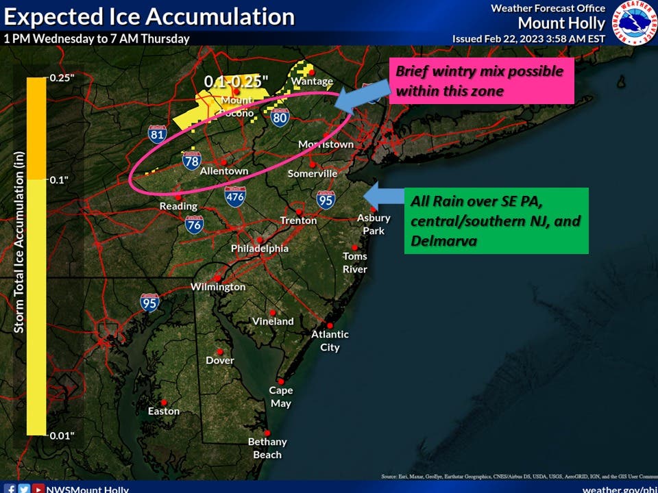
Rain will fall throughout much of the state later Wednesday, with a brief wintry mix possible in the western and central portions of North Jersey, the National Weather Service says. Temperatures will then rise overnight, with expected peaks in the mid-70s Thursday for parts of the state.
.jpg)
Minor coastal flooding also remains possible Wednesday and Thursday in Monmouth, Ocean and Cape May Counties. Additionally, dense fog may become widespread Wednesday in Ocean County, according to the National Weather Service.
Find out what's happening in Across New Jerseyfor free with the latest updates from Patch.
A Friday cold front will bring temperatures down to the teens into the weekend, according to regional forecasts. Saturday includes a chance of light snow in the state, but the National Weather Service's Mount Holly office will "wait for guidance to get a better read on this disorganized pattern."
Before you travel, check out AccuWeather's New Jersey radar for local conditions.
Find out what's happening in Across New Jerseyfor free with the latest updates from Patch.
Meteorologists expect precipitation to move in from the west and southwest later Wednesday morning into the early afternoon. By mid-afternoon, precipitation should reach most of the state.
Parts of North Jersey may get enough cold air for some light snow or sleet, with some ice accumulation possible in Sussex County's elevated terrain, the National Weather Service said. The agency issued a hazardous weather outlook for western Passaic County, which could see light freezing rain Wednesday night.
Forecasters expect plain rain in northwestern New Jersey by 1 a.m. Thursday.
Temperatures throughout the state will rise through the night as a warm front lifts north, according to weather officials. But forecasters aren't sure how far north the system will stretch, which could mean a sharp divide Thursday in temperatures from north to south, the National Weather Service says.
In North Jersey, officials expect clouds and even some showers Thursday, with highs only reaching the mid-50s. Meanwhile, forecasters expect sunshine and highs in the mid-to-low 70s throughout South Jersey.
Friday should feature dry conditions. But a cold front will take root, bringing some temperatures into the low 20s and teens from Friday evening through Saturday morning, forecasters say.
The unsettled weather pattern follows Tuesday's significant storm in which a tornado developed in Mercer County late that afternoon. The confirmed tornado marks New Jersey's first in February since 1999, when the phenomena occurred in Cherry Hill, according to federal data. Read more: National Weather Service Investigating Possible Tornado In Mercer Co.
The tornado displaced about 60 residents in the Quaker Bridge area, with the Red Cross and Volunteers of America helping them find temporary housing. The National Weather Service will continue to survey damage and expects to release more details later Wednesday afternoon or early evening.
Here's the National Weather Service's latest North Jersey forecast:
- Wednesday: Rain and sleet likely between 1 p.m. and 4 p.m., then rain. High near 46. Calm wind becoming southwest around 5 mph in the afternoon. Chance of precipitation is 90 percent. Little or no sleet accumulation expected.
- Wednesday night: Rain, mainly before 4 a.m. Low around 36. Northeast wind 5 to 9 mph becoming light after midnight. Chance of precipitation is 80 percent. New precipitation amounts of less than a tenth of an inch possible.
- Thursday: A chance of rain before 10 a.m., then a slight chance of showers after 4 p.m. Mostly cloudy, with a high near 55. Calm wind becoming north 5 to 7 mph in the morning. Chance of precipitation is 30 percent.
- Thursday night: A 30 percent chance of showers, mainly before 10 p.m. Mostly cloudy, then gradually becoming mostly clear, with a low around 34. Calm wind becoming west 5 to 9 mph after midnight.
- Friday: Mostly sunny, with a high near 44. Windy, with a west wind 18 to 28 mph, with gusts as high as 38 mph.
- Friday night: Mostly clear, with a low around 21.
- Saturday: A chance of rain and snow showers after 1 p.m. Partly sunny, with a high near 33. Chance of precipitation is 30 percent.
- Saturday night: Mostly cloudy, with a low around 26.
- Sunday: Partly sunny, with a high near 49.
Here's the agency's latest South Jersey forecast:
- Wednesday: Rain likely, mainly before 3 p.m. Cloudy, with a high near 47. East wind 5 to 10 mph. Chance of precipitation is 60 percent. New precipitation amounts of less than a tenth of an inch possible.
- Wednesday night: A chance of rain before midnight, then a chance of rain after 2 a.m. Areas of fog after 1 a.m. Otherwise, mostly cloudy, with a temperature rising to around 51 by 5 a.m. East wind 10 to 15 mph becoming southwest after midnight. Chance of precipitation is 50 percent. New precipitation amounts of less than a tenth of an inch possible.
- Thursday: Mostly sunny, with a high near 64. Breezy, with a west wind 10 to 20 mph.
- Thursday night: Mostly clear, with a low around 46. Breezy, with a southeast wind 5 to 10 mph becoming west 15 to 20 mph after midnight.
- Friday: Sunny, with a high near 50. Breezy, with a west wind 20 to 25 mph.
- Friday night: Partly cloudy, with a low around 25.
- Saturday: A chance of snow showers after 1 p.m. Mostly cloudy, with a high near 38. Chance of precipitation is 30 percent.
- Saturday night: A chance of snow before 1 a.m. Mostly cloudy, with a low around 31. Chance of precipitation is 30 percent.
- Sunday: Mostly sunny, with a high near 51.
Get more local news delivered straight to your inbox. Sign up for free Patch newsletters and alerts.